


So the Allies won in the end.
Great game report! I enjoyed reading it.
Do they get the infantry in South America?
So America gets plus 8IPC income.
Is the NO expanded?
Is S.A. homeland terry as well?
A little bit more info please cow.
It sounds interesting.
Do they get the infantry in South America?
I would say yes; at least this is how I understand it. The big question for me is: Do you mean the whole continent or just Brazil?
Anyway, a nice suggestion.
The whole continent. Start the game, adjust the income, get the infs. It is not bad. No need to bid, if you want to you can do something small, even 3 ipc goes a long way in egypt or just make the 2 African territories worth 1 ipc part of UK and give them the 4 inf. The inf stay where the territory is and can move out round 1.
Anyway doing South America to USA feels much more organic. Latin America did support the allies, mostly under the table, some of which direct with strait up ships, canadian airforce volunteers and trade.
I like this system because it is much more forgiving for both sides. Extra sub every round goes a long way and the starting inf help usa get rolling sooner so less crazy 20+ bids are needed.
In practical terms, it’s not necessary for the US to control all of South America to get the full bonus income and the full bonus infantry being described here because Colombia, Ecuador, Peru, Bolivia, Paraguay, Uruguay, British Guiana, Suriname and French Guiana have neither standing armies nor IPC income values. All the US needs to control is Brazil, Venezuela, Argentina and Chile (for a total of 11 standing army infantry units and 8 IPCs), which is more plausible than controlling the whole continent. The four countries involved are credible as US WWII allies, though to varying degrees. Brazil declared war on the Axis in mid-1942 and actually contributed combat troops to the European theatre in 1944. Venezuela was technically neutral until late in the war, but it provided lots of oil to the Allies. Chile was neutral for most of the war, but broke relations with the Axis in 1943. Argentina was a complicated case: like Chile, it broke relations with the Axis in 1943 and only made a late entry into the war, but it was in an awkward position because on the one hand it was traditionally close to Germany and it had an authoritarian government, while on the other hand it was under US pressure to side with the Allies.
One question for Cow: when you say “get the infs”, meaning that the standing armies of these four countries become US units, do they simply stay where they are? I assume so, because I think the only way they could legitimately be moved to the European front would be by naval transport.
What you should consider with this change is that now there won’t be as much of a dissuasion for the Axis to declare war on the neutrals. In fact, neutral crushes might even happen in most games with this.
It is mostly Turkey and Spain that dissuades axis from dowing neutrals, that is it. (oh sure 4 inf by india and saudi arabia and south africa)
Anyway. Yes, I usually just do the cash flow SA places, less editing. Argentina provided airmen to Canadian/Royal Air force. Chile provided a few ships to USA. Venezuela late DOW. They all supported the allies through trade as well.
@Cow:
It is mostly Turkey and Spain that dissuades axis from dowing neutrals,…
Don’t forget Sweden (6 Inf. & German NO).
I like this idea a lot. From an ease of implementation standpoint it seems preferable to most other suggestions to rebalance the G40 game by sides. Nice work man!
:-D
Ps. I like Marc’s suggestion, again for ease of use, because it requires less USA roundels to get up and running.
sounds like a Excellent idea ! You could give the US the dough and leave the inf neutral until activated by a US ground unit. Shouldn’t make much difference. Might give a little flavor. : )
Yea good idea, sounds cool
Good idea Cow!… I hope it grows some legs.
tried it yesterday. liked it. will do it again.
If I remember the map right, you also need to include Columbia to make a US territory. It doesn’t have any IPCs or standing army, but it is located between Central America and Brazil/Venezuela. Argentina, Chile, Brazil and Venezuela all connect to one another but Columbia blocks the path to Central America and on up to the US.
I like this idea too because I’ve never cared for having to go around the neutrals, especially now that a lot of them are worth precious IPCs. I would carry this further:
All South American neutrals go to the US.
All African neutrals go to the UK.
Afghanistan, Saudi Arabia, Portugal and Ireland to the UK.
Sweden and Switzerland to Germany.
Spain to Italy.
Turkey to Russia.
Mongolia to Japan.
columbia doesn’t block. Venezuela is connected to panama.
All South American neutrals go to the US.
All African neutrals go to the UK.
Afghanistan, Saudi Arabia, Portugal and Ireland to the UK.
Sweden and Switzerland to Germany.
Spain to Italy.
Turkey to Russia.
Mongolia to Japan.
Are these allocations based on how likely these countries were to be conquered by the powers that get them? Or on the political leaning of these countries towards the powers that get them? Either way, some of the allocations leave me perplexed. Turkey and Russia were traditional enemies, with a long history of competing interests in the Balkans and the Black Sea. Mongolia was for all intents and purposes a subsidiary of the USSR, with whom it was on very cozy terms, and Japan had failed miserably in its late-1930s attempts to bite off pieces of it.
The beauty of COW’s suggestion is that it only involves changing the ownership of 4 territories, and they’re all in the same localized zone, so easy to adjust. Start adding in too much more, and the set up tweak will lose its essential charm.
There is only one further option I would consider, to tie this stuff together with a nice blue ribbon, and that is…
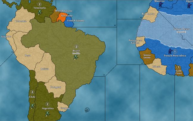
“Change the starting ownership of Sierra Leone from True Neutral to UK”
The reasons are both historical and gameplay oriented, since the British did have a naval base in Freetown.
The historical justification: since we are back-loading all those South American nations into the 1940 conflict, it makes sense to me to do the same with this W. African territory, which was involved in the conflict from early on. I honestly am not even sure why this territory is designated “true neutral” on the gameboard in the first place? Perhaps it was an error in the original draft that was never corrected?
CWO could probably provide some insights.
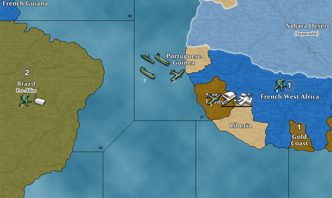
Gameplay justification: this way the Allies can build a naval base with access to sz 87, for the African shuck out of E. USA. And to make the new starting possessions in South America more useful with another staging zone. This seems a bit easier to me than changing all the French territory in Africa to UK, since its just the one spot.
That would be 5 total roundels, 4 neutrals to USA and 1 to UK. All in the same basic region of the game map. Easy to manage.
Any thoughts?
Sierra Leone.png_thumb
Sierra Leone.png_thumb
Sierra Leone.png_thumb
Sierra Leone.png_thumb
Sierra Leone.png_thumb
Sierra Leone.png_thumb
Sierra Leone.png_thumb
Sierra Leone.png_thumb
Sierra Leone.png_thumb
Sierra Leone.png_thumb
Sierra Leone.png_thumb
Sierra Leone.png_thumb
Sierra Leone.png_thumb
Sierra Leone.png_thumb
Sierra Leone.png_thumb
Sierra Leone.png_thumb
Sierra Leone.png_thumb
Sierra Leone.png_thumb
Sierra Leone.png_thumb
Sierra Leone.png_thumb
Sierra Leone.png_thumb
Sierra Leone.png_thumb
Sierra Leone.png_thumb
Sierra Leone.png_thumb
Sierra Leone.png_thumb
Sierra Leone.png_thumb
Sierra Leone.png_thumb
Sierra Leone.png_thumb
Sierra Leone.png_thumb
Sierra Leone.png_thumb
Sierra Leone.png_thumb
Sierra Leone.png_thumb
Sierra Leone.png_thumb
Sierra Leone.png_thumb
Sierra Leone.png_thumb
Sierra Leone.png_thumb
Sierra Leone.png_thumb
Sierra Leone.png_thumb
Sierra Leone.png_thumb
Sierra Leone.png_thumb
Sierra Leone.png_thumb
Sierra Leone.png_thumb
Sierra Leone.png_thumb
Sierra Leone.png_thumb
Sierra Leone.png_thumb
Sierra Leone.png_thumb
Sierra Leone.png_thumb
Sierra Leone.png_thumb
Sierra Leone.png_thumb
Sierra Leone.png_thumb
Sierra Leone.png_thumb
Sierra Leone.png_thumb
Sierra Leone.png_thumb
Sierra Leone.png_thumb
Sierra Leone.png_thumb
Sierra Leone.png_thumb
Sierra Leone.png_thumb
Sierra Leone.png_thumb
Sierra Leone.png_thumb
Sierra Leone.png_thumb
Sierra Leone.png_thumb
Sierra Leone.png_thumb
Sierra Leone.png_thumb
Sierra Leone.png_thumb
Sierra Leone.png_thumb
Sierra Leone.png_thumb
Sierra Leone.png_thumb
Sierra Leone.png_thumb
Sierra Leone.png_thumb
Sierra Leone.png_thumb
Sierra Leone.png_thumb
Sierra Leone.png_thumb
Sierra Leone.png_thumb
Sierra Leone.png_thumb
Sierra Leone.png_thumb
Sierra Leone.png_thumb
Sierra Leone.png_thumb
Sierra Leone.png_thumb
Sierra Leone.png_thumb
Sierra Leone.png_thumb
Sierra Leone.png_thumb
Sierra Leone.png_thumb
Sierra Leone.png_thumb
Sierra Leone.png_thumb
Sierra Leone.png_thumb
Sierra Leone.png_thumb
Sierra Leone.png_thumb
Sierra Leone.png_thumb
Sierra Leone.png_thumb
Sierra Leone.png_thumb
Sierra Leone.png_thumb
Sierra Leone.png_thumb
Sierra Leone.png_thumb
Sierra Leone.png_thumb
Sierra Leone.png_thumb
Sierra Leone.png_thumb
Sierra Leone.png_thumb
Sierra Leone.png_thumb
Sierra Leone.png_thumb
Sierra Leone.png_thumb
Sierra Leone.png_thumb
Sierra Leone.png_thumb
Sierra Leone.png_thumb
Sierra Leone.png_thumb
Sierra Leone.png_thumb
Sierra Leone.png_thumb
Sierra Leone.png_thumb
Sierra Leone.png_thumb
Sierra Leone.png_thumb
Sierra Leone.png_thumb
Sierra Leone.png_thumb
Sierra Leone.png_thumb
Sierra Leone.png_thumb
Sierra Leone.png_thumb
Sierra Leone.png_thumb
Sierra Leone.png_thumb
Sierra Leone.png_thumb
Sierra Leone.png_thumb
Sierra Leone.png_thumb
Sierra Leone.png_thumb
Sierra Leone.png_thumb
Sierra Leone.png_thumb
Sierra Leone.png_thumb
I have no idea why the map designates Sierra Leone as a neutral. It was British-controlled at the time: Freetown (where there was indeed a naval base during WWII) had the status of a British crown colony, while the rets of the country was a British protectorate. So this element of the map is indeed puzzling. Mind you, this is the same map which implies (by land colour and roundel) that Mexico, Central America and the West Indies are all part of the United States…so it’s hardly a model of geopolitical rectitude.
An argument could be made, by the way, that Sierra Leone’s game map neighbor Liberia ought to be a pro-Allied neutral. The US and Liberia were on very close terms during WWII: American troops served there, a lot of servicemen transited through it, and it was an important supplier of rubber at a time when Japan controlled many other sources for this material. In practical terms, however, this change wouldn’t affect very much because Liberia has no IPCs and no standing army.
At this rate why not give Mongolia to the Soviets? Maybe those six extra infantry can be the difference in a Moscow defense.
I like these rules because they don’t require anything to achieve beyond a few roundels and following the information that’s already printed on the map.
Just change the neutral ownership or standing armies in the designated area, and switch to new owner.
Here is a save edit, with the suggested changes…
I included the Sierra Leone correction. For the start date Sierra Leone should definitely belong to UK in 1940.
Having a West Africa space to UK that borders sz 87 provides an interesting possibility that isn’t available OOB, a repeating shuck for USA into Africa!
if UK chooses to build an NB, this could help to accelerate the US involvement on a possible torch or sub-saharan route, that doesn’t just hinge everything on Gibraltar.
The new USA possessions in South America, fits with the theme already present on the OOB map in central America and the Caribbean, that the nations in this hemisphere contribute directly to the US war effort. The 8 extra IPCs bring the USA to a clean 60 ipcs.
Nice and round! I like it a lot :-D
Ps. The Mongolia concept is interesting, historical, and easy enough to do, though I think as COW suggested the USA boost might be enough in and of itself.
I only mentioned Sierra Leone because it always annoyed me how Allies could not build a naval base on sz 87 because of the French ownership. And then every map I’ve seen of WW2 shows that Sierra Leone was under control of the Allies and a belligerent since 1940 at least, but I think as early as 39? So this seems like a map correction that should be encouraged.
Also, not yet mentioned but pretty cool as well… by adjusting starting ownership of Brazil, Venezuela, Chile and Argentina to USA, suddenly South America becomes a much more interesting target area for Axis. The region provides an overland route to the Canal (on account of the OOB geographical inaccuracy that has Venezuela bordering Panama hehe.) But redrawing the OOB map is not a good option for most players, and anyway this will be more fun for the gameplay since Columbia isn’t in the way. This means that the Germans or Italians or even Japanese might be able to land units in Chile or Argentina and make Operation Bolivar pay dividends haha.
Axis troops landed anywhere in South America, could conceivable reach anywhere else in South America by land. Production expansions in this region could provide another way “into the America.” You know for cool invasion USA dreams of the endgame! haha
:-D
I think the inclusion of Brazil as a US territory makes a lot of sense, and is familiar from the older games. The Sierra Leone possibility will activate Brazil for its historical role in the war, with proximity to Africa for support of the British and Americans fighting in that theater.
I didn’t want to bite off more than I could chew, but I’d make a gameplay case for Liberia to be Pro-Allies too! Because it is the only territory on sz 83. This could give the territory some minor significance as a potential Naval Base location. These nations were all Allies before the curtain fell, so it seems weird to have them as true Neutrals. To me true neutral indicates neutrality for the duration of the war. If we’re going to have the Pro-side concept, might as well extend it to all the territories that make sense.
I’m just a fan of giving Sierra Leone to UK outright, because it seems like an error/oversight of the OOB map, and because I like the idea of that sz 101 to sz 87 shuck. E. USA to W. Africa and back, NB to NB!
I think it would really help the USA to get out early and be more involved in Africa. ;)
On the whole I really like this South America idea. I think it looks fun, and feels simple to implement. No rules changes or anything too complicated, just a few roundels, a handful of infantry, and 60 ipcs for USA to start.
I’m partial to these American regions of the G40 map in tripleA, since I’m pretty sure it’s the only area of the map to use my v3 baseline as a guide. Though the borders where redrafted to match the OOB boundaries, the continent of South America itself and the West Indies and the Eastern coastline of North America follow the v3/Domination draft I made originally. It even has Roanoke! lol I had big plans for that one in a 16th century mod. But it disappeared without a trace! All except for a few pixels preserved in the G40 baseline for tripleA hahaha.
Another image, just kicking around some ideas. These routes might not be optimal for USA, but at least they’re on the table now…
Sub Saharan route.png_thumb
Sub Saharan route.png_thumb
Sub Saharan route.png_thumb
Sub Saharan route.png_thumb
Sub Saharan route.png_thumb
Sub Saharan route.png_thumb
Sub Saharan route.png_thumb
Sub Saharan route.png_thumb
Sub Saharan route.png_thumb
Sub Saharan route.png_thumb
Sub Saharan route.png_thumb
Sub Saharan route.png_thumb
Sub Saharan route.png_thumb
Sub Saharan route.png_thumb
Sub Saharan route.png_thumb
Sub Saharan route.png_thumb
Sub Saharan route.png_thumb
Sub Saharan route.png_thumb
Sub Saharan route.png_thumb
Sub Saharan route.png_thumb
Sub Saharan route.png_thumb
Sub Saharan route.png_thumb
Sub Saharan route.png_thumb
Sub Saharan route.png_thumb
Sub Saharan route.png_thumb
Sub Saharan route.png_thumb
Sub Saharan route.png_thumb
Sub Saharan route.png_thumb
Sub Saharan route.png_thumb
Sub Saharan route.png_thumb
Sub Saharan route.png_thumb
Sub Saharan route.png_thumb
Sub Saharan route.png_thumb
Sub Saharan route.png_thumb
Sub Saharan route.png_thumb
Sub Saharan route.png_thumb
Sub Saharan route.png_thumb
Sub Saharan route.png_thumb
Sub Saharan route.png_thumb
Sub Saharan route.png_thumb
Sub Saharan route.png_thumb
Sub Saharan route.png_thumb
Sub Saharan route.png_thumb
Sub Saharan route.png_thumb
Sub Saharan route.png_thumb
Sub Saharan route.png_thumb
Sub Saharan route.png_thumb
Sub Saharan route.png_thumb
Sub Saharan route.png_thumb
Sub Saharan route.png_thumb
Sub Saharan route.png_thumb
Sub Saharan route.png_thumb
Sub Saharan route.png_thumb
Sub Saharan route.png_thumb
Sub Saharan route.png_thumb
Sub Saharan route.png_thumb
Sub Saharan route.png_thumb
Sub Saharan route.png_thumb
Sub Saharan route.png_thumb
Sub Saharan route.png_thumb
Sub Saharan route.png_thumb
Sub Saharan route.png_thumb
Sub Saharan route.png_thumb
Sub Saharan route.png_thumb
Sub Saharan route.png_thumb
Sub Saharan route.png_thumb
Sub Saharan route.png_thumb
Sub Saharan route.png_thumb
Sub Saharan route.png_thumb
Sub Saharan route.png_thumb
Sub Saharan route.png_thumb
Sub Saharan route.png_thumb
Sub Saharan route.png_thumb
Sub Saharan route.png_thumb
Sub Saharan route.png_thumb
Sub Saharan route.png_thumb
Sub Saharan route.png_thumb
Sub Saharan route.png_thumb
Sub Saharan route.png_thumb
Sub Saharan route.png_thumb
Sub Saharan route.png_thumb
Sub Saharan route.png_thumb
Sub Saharan route.png_thumb
Sub Saharan route.png_thumb

