


@vodot I’ve actually used a couple of your files. SOme I’ve taken and reworked and made them for my game. Thanks again. Docfav
Tjoek's A&A Anniversary OOB Map file (Updated March 23rd)
-
Updated color enhancement, noise reduction and more cleanups
LAST UPDATE: March 23rd 2019Hi all!
It has been a while since I was active on this forum due to some personal struggles, but after seeing Young Grasshoppers video on the warped Anniversary boards I decided to step in and help the community to solve this issue. A couple of weeks ago I bought a second hand flatbed scanner which I modified to be able to scan large documents in multiple stages without the need of cutting the boards to pieces. This works great!
A&A Anniversary OOB Maps
I made 4 versions of the map (basically 2 versions and both with and without an IPC income tracker):
- Standard out of the box (OOB) map
- Same as above with IPC income tracker
- Removed A&A artwork and replaced Italian roundels with correct ones
- Same as above with IPC income tracker
See below for the four corresponding map files.
Please see my scan of the original game board with removed artwork and Italian Faces with 1/4 inch white border [400 dpi]:
Download the A&A Anniversary with removed artwork and Italian Faces Map here
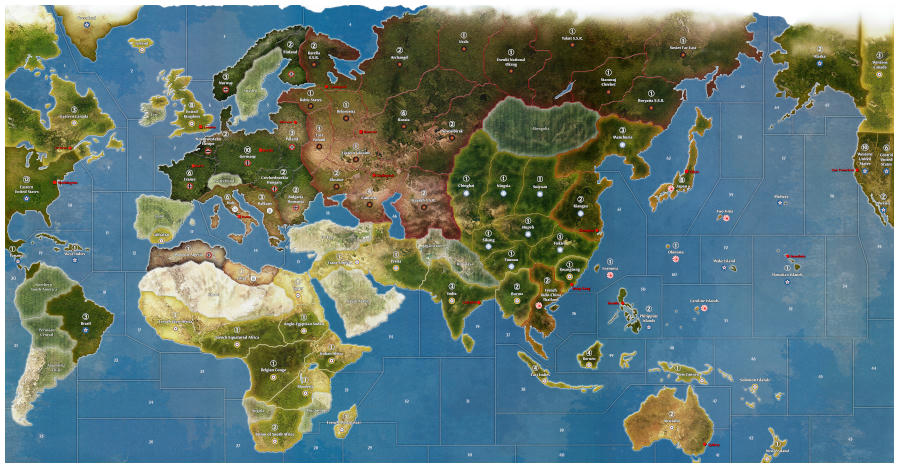
NOTE: this file can be enlarged and can easily print up to 72 inch (250dpi)Same file as above but with an 1/3 inch white border and an 1 inch high IPC income tracker [300 dpi]:
Download the A&A Anniversary with removed artwork and Italian Faces Map and IPC tracker here
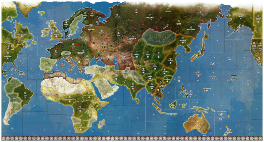
NOTE: if you scale this image the income tracker might look to big or to small. Just print it at 300 dpi which will result in a map 59.92 inch by 32.21 inch. Only then the tracker is 1 inch highPlease see my scan of the original game board with 1/4 inch white border [400 dpi]:
Download the A&A Anniversary OOB Map here
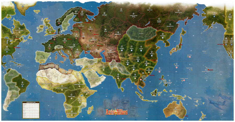
NOTE: this file can be enlarged and can easily print up to 72 inch (250dpi)Same file as above but with an 1/3 inch white border and an 1 inch high IPC income tracker [300 dpi]:
Download the A&A Anniversary OOB Map with IPC tracker here
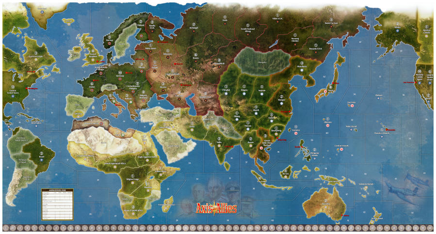
NOTE: if you scale this image the income tracker might look to big or to small. Just print it at 300 dpi which will result in a map 59.92 inch by 32.21 inch. Only then the tracker is 1 inch highWork done
What I’ve done so far (bold and italic items are either new our revisited):
- Scanned the brand new boards in multiple files in 400 dpi resolution (1/3rd high resolution then YG’s Global 1940 map)
- Stitched the 9 best files per board in a graphical editor
- Combined the 3 boards into one map and photo-shopped the borders between the 3 boards
- Retouched some stitching miss alignments
- Retouched the largest dust particles and printing errors on my map
- Fully retouched and corrected all stiching errors and small scratches and dust particles
- Enhanced the colours and contrast
- Reduced scanning noise
- Added a 1/4 inch white boarder
- Replaced roundels with the same but more vibrant artwork
- Version with Italian Fasces
- Version with 60 IPC tracker
- Exported to *.png image so no loss of details as with *.jpg to preserve the highest possible quality
- Re-positioned Honolulu to the right location
- Flipped Iwo Jima to the right orientation
- Removed non existing ‘Atlantis’ islands south of Philippines
- Centered territory names
- Germany
- France
- Kiangsu
- Stanovoj Chrebet
- Baltic States
- Rhodesia
- Egypt
- Poland
- Bulgaria Romania
- SZ 15
- Renamed “Anglo-Egypt Sudan” to correct “Anglo-Egyptian Sudan”
- Added SZ 66 name to the Caspian Sea
Stay tuned for more customizations like home made hit dice, my Litko based flight stands and my continuation on cleaning the Global 1940 Map.
But for now: Enjoy the map! And please let me know what you guys think of the map file and what could be enhanced or improved.
Cheers,
Tjoek -
Your file looks awesome to me.
If you’re taking suggestions, might i suggest replacing the original “Italian” roundels (they’re actually for Iran, not Italy) and replacing them with correct pattern Italian roundels. The correct pattern swaps the green and the red, so that the red is on the outer ring.
-Midnight_Reaper
-
Your file looks awesome to me.
Thanks!
If you’re taking suggestions, might i suggest replacing the original “Italian” roundels (they’re actually for Iran, not Italy) and replacing them with correct pattern Italian roundels. The correct pattern swaps the green and the red, so that the red is on the outer ring.
Yes this roundel is the current Iran one, but Italy did use this roundel since WW 1. They only started using the the red (outer ring), white, green (center) one in 1943 after the Southern part of Italy joined the Allies. But during the war they actually used a completely different design.

So to my knowledge the correct roundel is this black and white roundel, closely followed by the one on the OOB game board. Simply because Italy hasn’t joined the allies yet in this game.
Nonetheless with only three roundels that need replacing it is easy enough to make an extra variant.
-
Hi Tjoek,
I really like your file for Axis & Allies Anniversary edition. I missed out on this version of the game when it was originally released almost 10 years ago. I just picked up the rereleased version of the 50th Anniversary Edition and am excited to use your file for a seamless printed map!
I do want to ask about the possibility of what would hopefully be a small enhancement and time commitment. Would you be able to make the borders a bit more pronounced, especially in the Eastern Front and most of the northern Asia region that Soviet Russia holds? I am finding that I am having difficulty seeing the borders on the actual map that comes with the game. I don’t know if it would look best to widen them, darken them, or lighten them, but it would be most appreciated if you have the time to look into the best way of doing this!
I didn’t have as much trouble with my hard copy of the Global 1940 boards that came with the Europe 1940 and Pacific 1940 games, so I was surprised that I had difficulty distinguishing the borders on the Anniversary map.
Also, I look forward to printing your 2nd Edition Global 1940 map from your other thread when it is completed and posted. I looked through the before/after pictures you posted, and your work is absolutely amazing! Thank you for your contributions you have already made and are making ongoing!
-
Has anyone actually printed this map? Maybe its just me, i dunno, but it seems subdued/pixelated compared to the Adobe Maps of Dedo and Imperious… but i could totally be off base or maybe i need glasses?
-
Its probably because its not PDF or PNG and its a jpeg
-
@Nowhere:
Has anyone actually printed this map? Maybe its just me, i dunno, but it seems subdued/pixelated compared to the Adobe Maps of Dedo and Imperious… but i could totally be off base or maybe i need glasses?
How did you print it? The png provided has 150 ppi.
-
@P@nther:
@Nowhere:
Has anyone actually printed this map? Maybe its just me, i dunno, but it seems subdued/pixelated compared to the Adobe Maps of Dedo and Imperious… but i could totally be off base or maybe i need glasses?
How did you print it? The png provided has 150 ppi.
I looked into printing it this week, they said the file was huge and they converted it into a JPEG for me… also working on a couple tweaks before printing, I’ll share when I’m done.
-
@Young:
@P@nther:
@Nowhere:
Has anyone actually printed this map? Maybe its just me, i dunno, but it seems subdued/pixelated compared to the Adobe Maps of Dedo and Imperious… but i could totally be off base or maybe i need glasses?
How did you print it? The png provided has 150 ppi.
I looked into printing it this week, they said the file was huge and they converted it into a JPEG for me… also working on a couple tweaks before printing, I’ll share when I’m done.
Indeed, tweaking it is the point.
The image has 17776x9162 pixels. At 150 dpi this would be a print size of 118,5 x 61,1 inches.
So to print it at reasonable sizes you need to either scale it (enhance dpi) or resize it (change horizontal/vertical amount of pixels) - or do a combination of both.
Depending on how this is done quality issues may occur - additionally to a possible jpg-quality-loss.I am curious how it worked for you.
-
@P@nther:
@Young:
@P@nther:
@Nowhere:
Has anyone actually printed this map? Maybe its just me, i dunno, but it seems subdued/pixelated compared to the Adobe Maps of Dedo and Imperious… but i could totally be off base or maybe i need glasses?
How did you print it? The png provided has 150 ppi.
I looked into printing it this week, they said the file was huge and they converted it into a JPEG for me… also working on a couple tweaks before printing, I’ll share when I’m done.
Indeed, tweaking it is the point.
The image has 17776x9162 pixels. At 150 dpi this would be a print size of 118,5 x 61,1 inches.
So to print it at reasonable sizes you need to either scale it (enhance dpi) or resize it (change horizontal/vertical amount of pixels) - or do a combination of both.
Depending on how this is done quality issues may occur - additionally to a possible jpg-quality-loss.I am curious how it worked for you.
Yes the right size for me 118 x 61
Any way my printer just reformat ( maybe wrong word ) it to the size I wanted. So when I got my map made too 4 x 8
It took him and hour to redo the size. -
I’ve never printed a game map before, but I am excited to start doing this, starting with Axis & Allies Anniversary Edition. With this file, if printed on vinyl at about 3 ft by 6 ft there anything I should know or processes I should take to get a clean, clear print?
-
I’ve never printed a game map before, but I am excited to start doing this, starting with Axis & Allies Anniversary Edition. With this file, if printed on vinyl at about 3 ft by 6 ft there anything I should know or processes I should take to get a clean, clear print?
This size can be achieved without modifying the pixel count and without quality effects simply by scaling: enhance dpi from 150 to 250.
While keeping the pixels at 17776x9162 this - when printing with 250 dpi - results in an image size of 71,1x36,6 inches, so approximately 6x3 ft.This is an easy task for your image manipulation software.
However, I am not a printing expert - so others hopefully add their knowledge regarding the printing aspects.
-
The guy I went through in Seattle just asked for the image and the dimensions I wanted and he handled the rest. Not sure where you are located but I would highly recommend this guy to anybody. I will use him once I am done with my custom map
-
I guess what i’m asking is this file going to give you a basically perfect reproduction of the OOB map, just on your material/size of your choice without looking pixilated or color saturated/faded?
YG, i’m really curious to see your results and/or modifications.
I’ve played every version of A&A from Classic to 1941 through Global… out of all, (for me and my friends) we’ve settled on Anniversary as our game of choice… not that we don’t like Global (we do), it just takes up too much of the time we’re willing to give and we all enjoy the balance of Anniversary for both gameplay and time investment… having said that, we are looking to print the best possible map for our group… and we’re all debating on which one is the best (we can’t decide)… we like the work of Imperious and Dedo, as well as possibly going with a reprint of the OOB map such as on here… we just need a nice bigger map than OOB… so we’re taking our time to find THE PERFECT map for us, and hoping to see results of what other people have chosen for AA50.
-
I think the minimum DPI should be 300 and to convert to jpeg due to memory issues will make the image unsustainable for any printing. I hope the work can be redone is another format to avoid the pixilation problem.
But you know my map redo is 100% vector, no image loss at any scale!
-
@Imperious:
But you know my map redo is 100% vector, no image loss at any scale!
I really like your map Imperious!
-
I just returned from a week long skiing trip, so this is a short reply to hopefully answer some of the questions.
The scan has been created with 400 dpi. Knowing that 250 dpi is the limit for high quality print work, you can easily enlarge the print to 1.5 times the size of OOB. (roughly 71.1 inch by 36.6 inch)
Even a dpi of 200 might hardly be noticeable during game play so you could go to twice the OOB size. (88.9 inch by 45.8 inch)
@Imperious Leader: the file really is PNG. The pixel effect you see in the file is scanning noise which is created by the scanner. And saving it as PDF helps nothing in my case, given the fact my file is PNG already which is a lossless compression.
-
@P@nther:
I’ve never printed a game map before, but I am excited to start doing this, starting with Axis & Allies Anniversary Edition. With this file, if printed on vinyl at about 3 ft by 6 ft there anything I should know or processes I should take to get a clean, clear print?
This size can be achieved without modifying the pixel count and without quality effects simply by scaling: enhance dpi from 150 to 250.
While keeping the pixels at 17776x9162 this - when printing with 250 dpi - results in an image size of 71,1x36,6 inches, so approximately 6x3 ft.This is an easy task for your image manipulation software.
However, I am not a printing expert - so others hopefully add their knowledge regarding the printing aspects.
You are right P@nther, the files is limited by it’s pixels simply because it’s a scan of the original which has a limited pixel resolution. In this case it was scanned with 400 pixels per inch to keep file size reasonable and be able to enlarge the file to roughly twice the size of the original map.
-
@Nowhere:
Has anyone actually printed this map? Maybe its just me, i dunno, but it seems subdued/pixelated compared to the Adobe Maps of Dedo and Imperious… but i could totally be off base or maybe i need glasses?
At what size do you want to print the file? As per my last response you should be fine around 80 inch wide. But you can easily make a test print of a small portion of the map at the number of pixels per inch you want to go for to see the effects of enlarging the file.
Let me know if it helps if I create a few files of different enlargements that are small enough to print on a standard A4 or Letter page. Then you can see for yourself. Do know that colors will always differ between your home prints and professional print equipment.
-
@Imperious:
I think the minimum DPI should be 300 and to convert to jpeg due to memory issues will make the image unsustainable for any printing. I hope the work can be redone is another format to avoid the pixilation problem.
But you know my map redo is 100% vector, no image loss at any scale!
Imperious Leader, I just looked at your map and to be honest your map is NOT 100% vector. Yes your borders, roundels and country names are vector and will be crisp and clear no matter the size it’s being printed in. But the background of the countries is still a so called raster image just like my map file. To be honest to the community your raster image measures 6074 by 3242 pixels which is far less then mine 17776 by 9162 pixels.
So your map will not scale to any size perfectly, but I have to admit the borders, roundels and names will look more crisp then mine with sizes over twice OOB, due to the vector elements you’ve added. But the background of your countries will not.
Suggested Topics

