Heroic Leaders
Soviet Union
Vasily Zaytsev Soviet Sniper during the battle of Stalingrad killed 225 soldiers including 11 snipers. Pick one Russian soldier. If garrisoned in a region containing a city Vasily may roll to shoot an enemy in an adjacent region (hits on 2 or less). This takes his action for the turn and he may not participate in any other combat for the remainder of the round.
Germany
Hermann Balk German Tank Commander whose lone Panzer Division nearly destroyed the entire Soviet Fifth Tank Army in three weeks. Pick a German tank. For the duration of the game this unit has +1 to combat rolls against Soviet Tanks.
Dietrich Von Sauken Prussian Nobleman, a tough veteran of every WW1 front. Saluted Hitler with a classic bent arm, typically sporting a cavalry sword, facial wounds and monocle. Dietrich asserted his command in spite of vocal anti-Nazi views while instrumental in the Kursk, Barbarossa, Minsk, and Moscow offensives. Pick a soldier. This motorized unit fights has an increased movement to two. May retreat two spaces, but cannot blitz like tanks and must end in first enemy territory entered. VonSauken supports two soldiers acting as an artillery piece.
Hans Rudel German Aviator veteran of 2,530 ground attack missions, over 50 aerial victories and claimed to have destroyed over 800 enemy vehicles of all types. Deploy a plane in Germany, this unit takes two hits to defeat. However, Hans may not take a damage meant for ground units, only for another air unit. At the end of the round if Hans survives he is restored to full health if ending in a starting German controlled territory.
United Kingdom:
Robert Ryder British Sailor, commanded a force of small unprotected transport ships during the daring raid of St. Nazaire dry docks. Instead of withdrawing as commanded, Ryder strafed fire for an hour and fifteen minutes recovering as many wounded as possible. Pick a transport. 1 adjacent allied land unit may choose to retreat to Ryder’s ship instead of fighting in a battle if there is space. This action is determined by the British player before the battle. Additionally, in an amphibious assault retreat if there are not enough transport ships for the British player, they may overload this ship but it may only offload retreated units to friendly territories.
Charles Upham New Zealand Platoon Leader, awarded the Victoria Cross twice. An offensive tactical might fighting in Crete, Greece, and El Almein. Place a soldier in British controlled Balkans, TransJordan, or Egypt during the deployment phase. This unit negates German and Italian artillery to a 1 while participating in an offensive.
Japan
Tameichi Hara Destroyer Captain, Tameichi had the highest hit % of any destroyer in the war. Wrote the torpedo tactics for the Empire of Japan, a samurai descendent, and fierce drinker. Pick a destroyer. This is now commanded by Tameichi Hara and will re-roll missed dice once for that piece.
Italian Famous Maneuver
Charge of the Savoia Cavalleria Anachronistic Italian Cavalry charge. In 1942 the Piedmont Count Alessandro Cazzago led a mounted assault against soviet troops, capturing 600 killing 150 and wounding 300 more. Italian forces lost 32 and well over a 100 horses. The Count’s mount Albino lived as well as the heroic counterattack shocking the Eastern Front. Once per game, if Germans lose and retreat Italy may counterattack with tanks and troops from up to two spaces away. The first round of this counterattack applies losses without retaliation.
United States
Colonial Draft: Place one soldier in Puerto Rico (West Indies) and the Philippines
Native American Allies: Recruit an infantry in Central United States and Alaska
Soviet Union Famous Maneuver
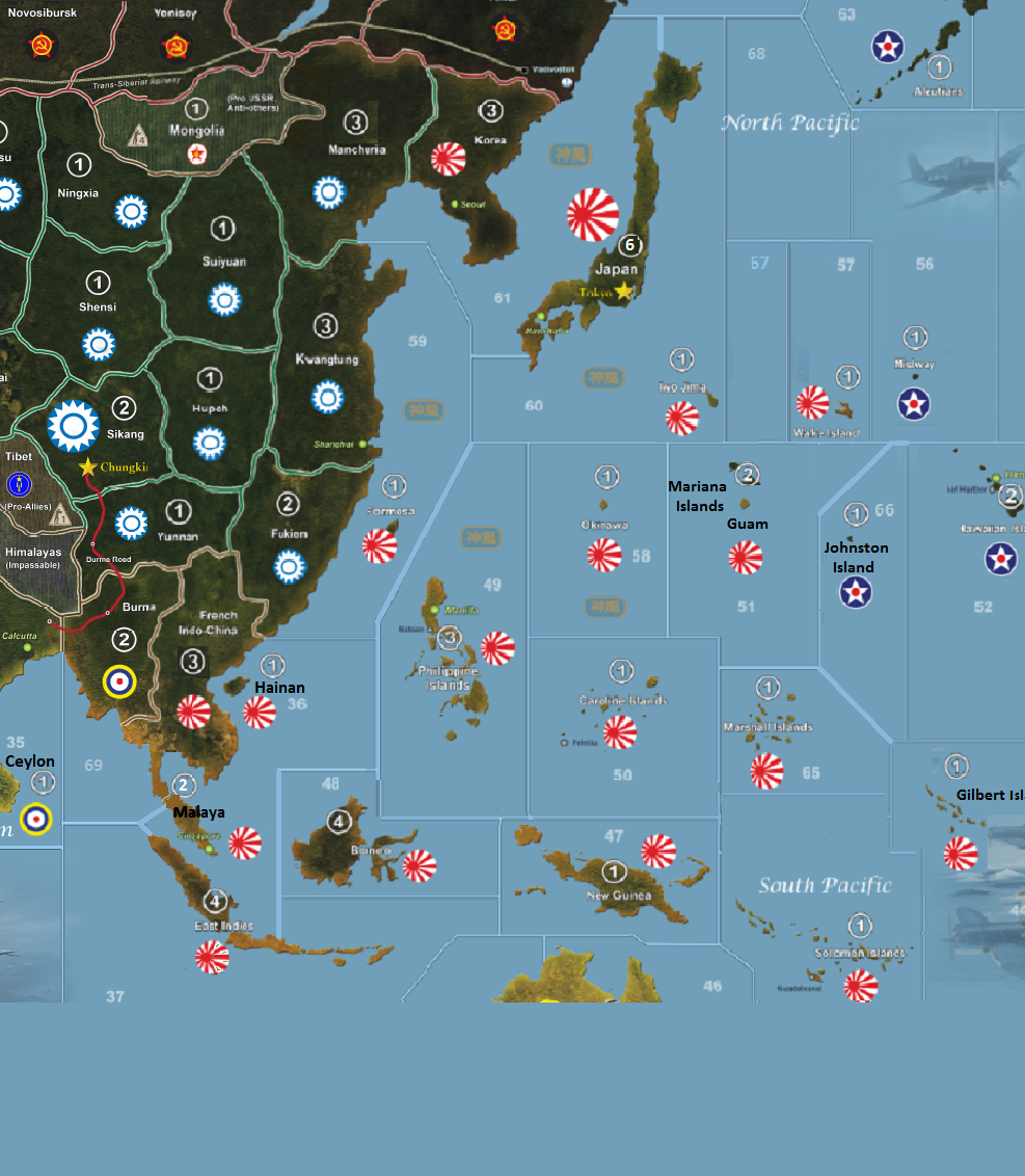
Khalakin Ghol: Japan failed to take Mongolia buffered with Soviet assistance. 1 Russian troop placed in Mongolia with a value of 1 IPC. Only one soldier may garrison or attack Mongolia at any given time without air support. Only one offensive against this region may occur per round.
Far East Railway: Soviet Tanks move 3 spaces eastward.
Japan Famous Maneuver:
Kamikaze: Japan fighters can engage in combat without designating a place to land afterwards. If this choice is made in a sea space it is destroyed after two rounds of sustained combat. On land, if the space is captured on the offensive and the plane is forced to make a crash landing, roll a dice. If the dice is on an even number the plane did not survive the emergency landing and is destroyed.