


Would this be at the beginning of game turn or each players turn?
Each players turn.
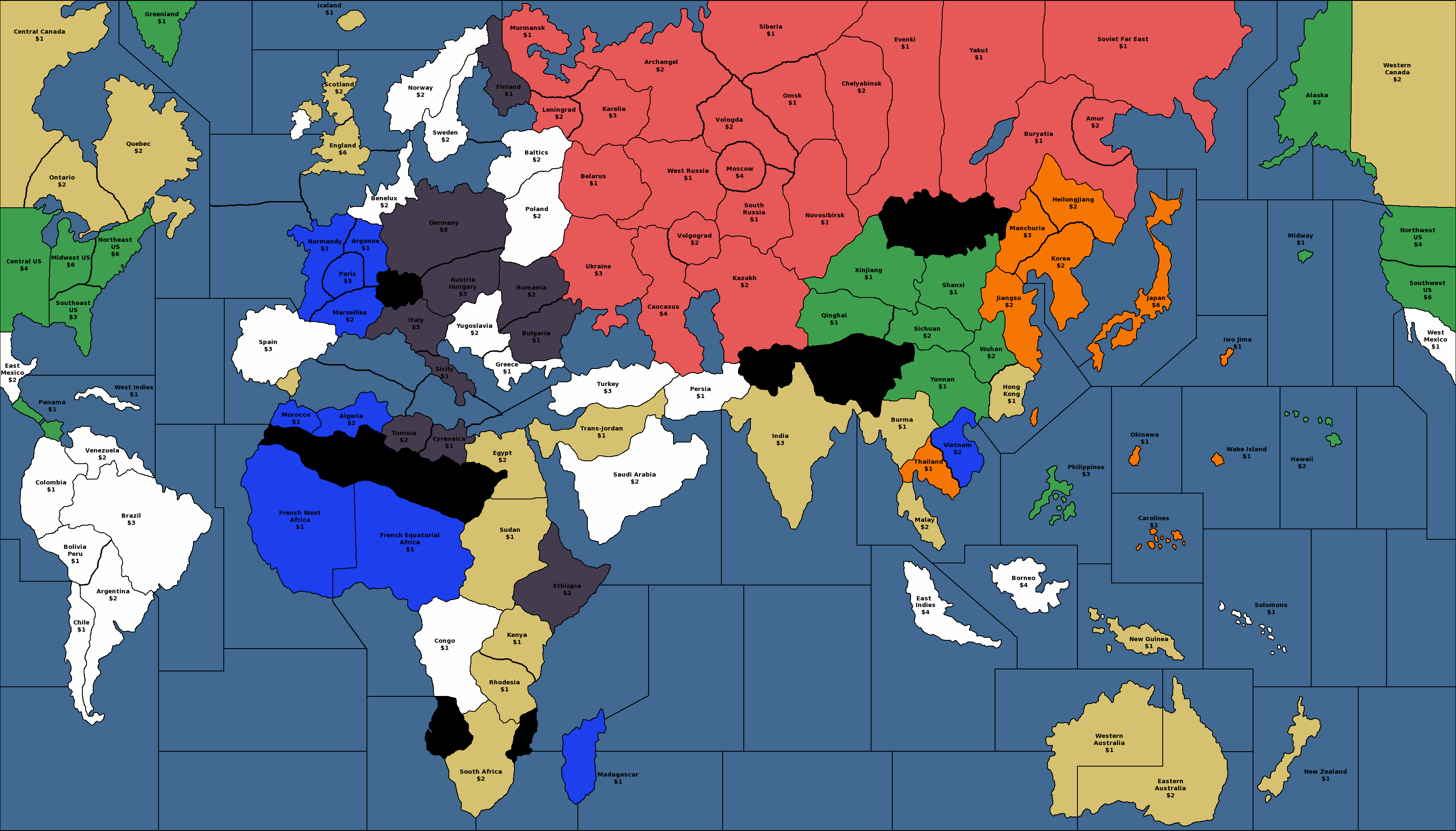
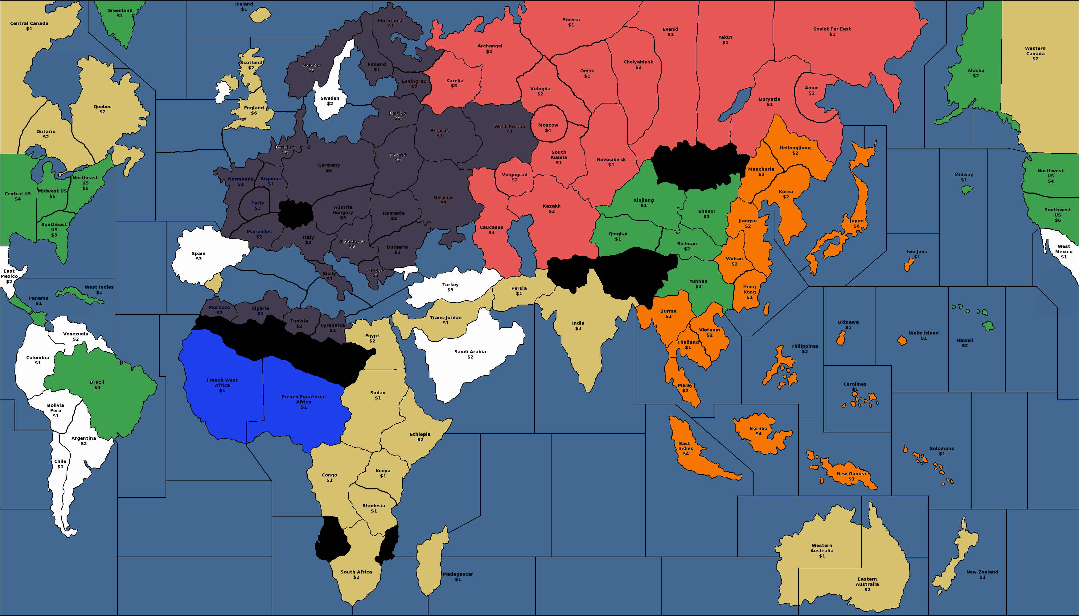
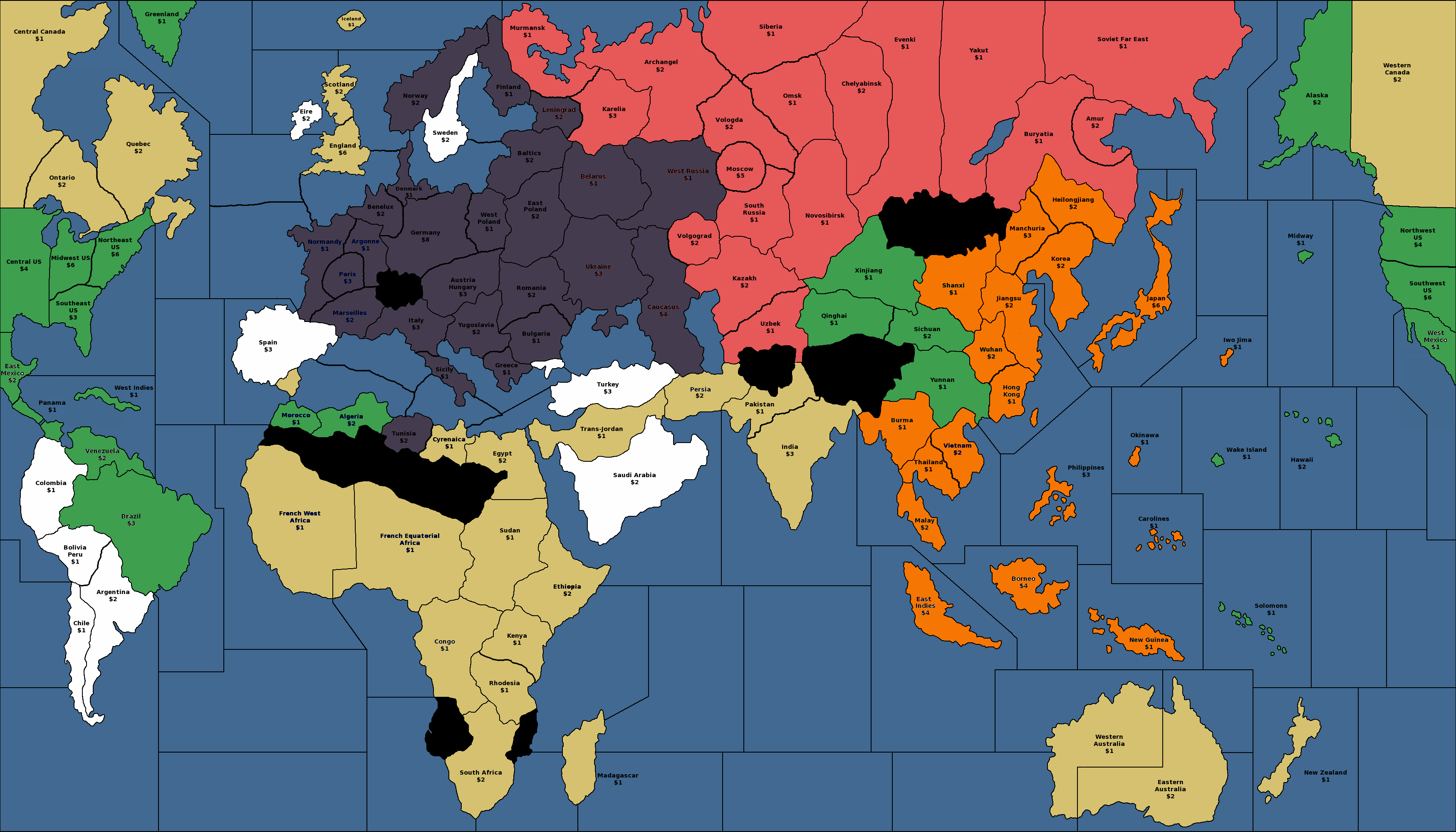
Hello! Black_Elk was kind enough to give me a basic A&A map image to play around with, and I’ve made a few changes that I think will enhance the strategic options for players who want a little more flexibility and sharpness in their games. I’m attaching pictures of the map with a 1939, 1942, and 1943 start date in case people want to use it for any of their house rules scenarios.
The big changes are:
USA, Canada, Britain, France, South America, the Mediterranean Sea, and the Baltic Sea now have several subdivisions, which makes invading them more realistic – if you want to defend your territories in the west, now you have to actually maintain several garrisons and (probably) some kind of offensive force that can help take back an enemy beachhead.
Russia is now consciously designed with a series of strongholds in mind – Karelia, Volgograd, Moscow, Chelyabinsk, and Vladivostok (Amur). Amur is no longer adjacent to Manchuria, so it’s not trivial for the Japanese to occupy it on turn 1. Each stronghold comes with a factory and can be neatly equipped to hold and trade the territory surrounding it. This gives Russia things to think about beyond just efficient trading and trying to delay the German march on Moscow.
Russia’s income is mostly in the west, but Russia’s factories are mostly in the east, meaning that while it is now harder for Germany to take Moscow, it is easier for Germany to take and hold eastern Europe and earn enough money from doing so to successfully defend against an Anglo-American invasion, and maybe even to turn around and attack Britain. This should reduce the ‘race to Moscow’ effect.
East Asia has a couple more territories added that allow the players to build more useful factories and trade territories without immediately wiping each other out. I’m aiming for the sweet spot between 1940 (an endless sea of Chinese and Siberian territories, no one of which is of any actual importance) and 1942.2 (too few territories for the Allies to bother with making a stand in the east).
More generous territory values in the Pacific ocean, encouraging players to go island hopping without the need for national objectives. Obviously the Solomon islands aren’t literally manufacturing goods with a value equal to those produced by Bulgaria or Greece, but control of the Pacific islands was economically quite useful as a way of saving money on fuel, shipping, spare parts, etc., and now the map reflects that.
1939 map.png_thumb
1942 map.png_thumb
1939 map.png_thumb
1942 map.png_thumb
1939 map.png_thumb
1942 map.png_thumb
1939 map.png_thumb
1942 map.png_thumb
1939 map.png_thumb
1942 map.png_thumb
1939 map.png_thumb
1942 map.png_thumb
1939 map.png_thumb
1942 map.png_thumb
1939 map.png_thumb
1942 map.png_thumb
1939 map.png_thumb
1942 map.png_thumb
1939 map.png_thumb
1942 map.png_thumb
1939 map.png_thumb
1942 map.png_thumb
1939 map.png_thumb
1942 map.png_thumb
1939 map.png_thumb
1942 map.png_thumb
1939 map.png_thumb
1939 map.png_thumb
1942 map.png_thumb
1942 map.png_thumb
1942 map.png_thumb
1942 map.png_thumb
1942 map.png_thumb
1942 map.png_thumb
1942 map.png_thumb
1942 map.png_thumb
1942 map.png_thumb
1942 map.png_thumb
1942 map.png_thumb
1942 map.png_thumb
1942 map.png_thumb
1942 map.png_thumb
1942 map.png_thumb
1942 map.png_thumb
1942 map.png_thumb
1942 map.png_thumb
1942 map.png_thumb
1942 map.png_thumb
1942 map.png_thumb
1942 map.png_thumb
1942 map.png_thumb
1942 map.png_thumb
1942 map.png_thumb
1942 map.png_thumb
1942 map.png_thumb
1942 map.png_thumb
1942 map.png_thumb
1942 map.png_thumb
1942 map.png_thumb
1942 map.png_thumb
1942 map.png_thumb
1942 map.png_thumb
1942 map.png_thumb
1942 map.png_thumb
1942 map.png_thumb
1942 map.png_thumb
1942 map.png_thumb
1942 map.png_thumb
1942 map.png_thumb
1942 map.png_thumb
1942 map.png_thumb
1942 map.png_thumb
1942 map.png_thumb
1942 map.png_thumb
1942 map.png_thumb
1942 map.png_thumb
1942 map.png_thumb
1942 map.png_thumb
1942 map.png_thumb
1942 map.png_thumb
1942 map.png_thumb
1942 map.png_thumb
1942 map.png_thumb
1942 map.png_thumb
1942 map.png_thumb
1942 map.png_thumb
1942 map.png_thumb
1942 map.png_thumb
1942 map.png_thumb
1942 map.png_thumb
1942 map.png_thumb
1942 map.png_thumb
1942 map.png_thumb
1942 map.png_thumb
1942 map.png_thumb
1942 map.png_thumb
1942 map.png_thumb
1942 map.png_thumb
1942 map.png_thumb
1942 map.png_thumb
1942 map.png_thumb
1942 map.png_thumb
1942 map.png_thumb
1942 map.png_thumb
1942 map.png_thumb
1942 map.png_thumb
1942 map.png_thumb
1942 map.png_thumb
1942 map.png_thumb
1942 map.png_thumb
1942 map.png_thumb
1942 map.png_thumb
1942 map.png_thumb
1942 map.png_thumb
1942 map.png_thumb
1942 map.png_thumb
1942 map.png_thumb
1942 map.png_thumb
1942 map.png_thumb
1942 map.png_thumb
1942 map.png_thumb
1942 map.png_thumb
1942 map.png_thumb
1942 map.png_thumb
1942 map.png_thumb
1942 map.png_thumb
1942 map.png_thumb
1942 map.png_thumb
1942 map.png_thumb
1942 map.png_thumb
1942 map.png_thumb
1942 map.png_thumb
1942 map.png_thumb
1942 map.png_thumb
1942 map.png_thumb
1942 map.png_thumb
1942 map.png_thumb
1942 map.png_thumb
1942 map.png_thumb
1942 map.png_thumb
1942 map.png_thumb
1942 map.png_thumb
1942 map.png_thumb
1942 map.png_thumb
1942 map.png_thumb
1942 map.png_thumb
1942 map.png_thumb
1942 map.png_thumb
1942 map.png_thumb
1942 map.png_thumb
1942 map.png_thumb
1942 map.png_thumb
1942 map.png_thumb
1942 map.png_thumb
1942 map.png_thumb
1942 map.png_thumb
1942 map.png_thumb
1942 map.png_thumb
1942 map.png_thumb
1942 map.png_thumb
1942 map.png_thumb
1942 map.png_thumb
1942 map.png_thumb
1942 map.png_thumb
1942 map.png_thumb
1942 map.png_thumb
1942 map.png_thumb
1942 map.png_thumb
1942 map.png_thumb
1942 map.png_thumb
1942 map.png_thumb
1942 map.png_thumb
1942 map.png_thumb
1942 map.png_thumb
1942 map.png_thumb
1942 map.png_thumb
1942 map.png_thumb
1942 map.png_thumb
1942 map.png_thumb
1942 map.png_thumb
1942 map.png_thumb
1942 map.png_thumb
1942 map.png_thumb
1942 map.png_thumb
1942 map.png_thumb
1942 map.png_thumb
1942 map.png_thumb
1942 map.png_thumb
1942 map.png_thumb
1942 map.png_thumb
1942 map.png_thumb
1942 map.png_thumb
1942 map.png_thumb
1942 map.png_thumb
1942 map.png_thumb
1942 map.png_thumb
1942 map.png_thumb
1942 map.png_thumb
1942 map.png_thumb
1942 map.png_thumb
1942 map.png_thumb
1942 map.png_thumb
1942 map.png_thumb
1942 map.png_thumb
1942 map.png_thumb
1942 map.png_thumb
1942 map.png_thumb
1942 map.png_thumb
1942 map.png_thumb
1942 map.png_thumb
1942 map.png_thumb
1942 map.png_thumb
Another scenario. Let me know if you have any constructive criticism!

1943 map.png_thumb
1943 map.png_thumb
1943 map.png_thumb
1943 map.png_thumb
1943 map.png_thumb
1943 map.png_thumb
1943 map.png_thumb
1943 map.png_thumb
1943 map.png_thumb
1943 map.png_thumb
1943 map.png_thumb
1943 map.png_thumb
1943 map.png_thumb
1943 map.png_thumb
1943 map.png_thumb
1943 map.png_thumb
Nice job Argothair. I have a question, why do you have the 2 french west africa territories blue in the 1942 and 43 maps? I like how now you can invade neutrals. So what new rules are adding? I like china bigger so US can build IC to put up a better fight.
My definite approval for giving the normally worthless pacific islands a value of 1! :-D
I’m convinced that something like this is necessary, to avoid island skipping by both sides, and to activate the theater beyond the usual b line to the money islands.
Aside from aesthetic stuff, my only concern would be the smaller territory space (for unit housing) on the Russian capital. Though how that plays out this may depend on the capital capture dynamic, and what sort of rules changes are involved.
There is a game in tripleA that used a somewhat similar production spread at the center of the map called Big World 1942, it used a city circle concept. As I recall the value of Moscow was at 4 ipcs, and this made for some really tense tight rope walking at the center, that really forced you to plan several rounds in advance. I always felt 4 was a bit low, though on that map G had more production in its core, and cheap Revised style tanks, which made the center crush easier to pull off. This might not be as much of an issue using a map based on the 1942.2 ruleset and unit cost structure.
Nice stuff though. I always enjoy seeing people ideas about new production spreads. These draft maps above, are much more in line with my ideal production spread and views on how to promote overall replay and theater balance, than the OOB 1942.2 map or the 1940 maps.
Cool stuff dude
“Volgograd” was not so named until after the death of Stalin.
Really hate maps that remove Germany’s north sea coastline.
Also hate that “West Russia” tt sticking into Russia in 1942; if you look at the front it was nothing like that - should be a more or less straight line Leningrad-Moscow-Stalingrad.
The real value in Pacific islands was as air bases for the Allies to reach bombing range for Japanese home islands. This is only effective if US/UK units are not allowed on USSR tts.
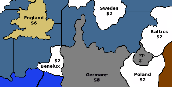
Is poor shrivelled little Irish Free State worth nothing?
Good comments, everyone!
So, in the next draft, I will up Moscow’s production to $5, color the French African colonies khaki on the '42/'43 maps, and show a $2 production for Eire.
Black_Elk, I used to play a bit of Big World on TripleA – the circle city concept was the only part of it I liked! That’s definitely where I stole the idea from. :-)
Flashman, I’m interested in hearing more about Germany’s north sea coastline and about West Russia’s borders – why are they important to you? Does it impact the game strategy somehow? How would you prefer to draw them? I don’t really understand what you mean by a “straight line” from Leningrad to Moscow to Stalingrad. Do you mean all three of those cities should be an equal distance from Berlin? Or just that it’s important for them to line up on the same line of longitude?
As far as I know, “Volgograd” was the name of the administrative district around Stalingrad both before, during, and after Stalin’s reign. The city, of course, changed its name from time to time.
Eastern Front should look more like this:
http://ww2.odu.edu/~jkoch/hist396/downloads/495.Eastern Front Map 1942.jpg
Netherlands and Denmark do not have a common border - Lower Saxony is in between. If you don’t want a single sea zone between UK & Germany it’s better to change where the sea zone border is drawn so that the entire German coast effectively lies within the Baltic.
Do you have any setup for any scenarios?
Poland is too far East, and Romania should have a Black Sea coastline.
balts.PNG_thumb
balts.PNG_thumb
balts.PNG_thumb
balts.PNG_thumb
balts.PNG_thumb
balts.PNG_thumb
balts.PNG_thumb
balts.PNG_thumb
balts.PNG_thumb
balts.PNG_thumb
balts.PNG_thumb
balts.PNG_thumb
balts.PNG_thumb
balts.PNG_thumb
balts.PNG_thumb
balts.PNG_thumb
balts.PNG_thumb
balts.PNG_thumb
balts.PNG_thumb
balts.PNG_thumb
balts.PNG_thumb
balts.PNG_thumb
balts.PNG_thumb
balts.PNG_thumb
balts.PNG_thumb
balts.PNG_thumb
balts.PNG_thumb
balts.PNG_thumb
balts.PNG_thumb
balts.PNG_thumb
balts.PNG_thumb
balts.PNG_thumb
balts.PNG_thumb
balts.PNG_thumb
balts.PNG_thumb
balts.PNG_thumb
balts.PNG_thumb
balts.PNG_thumb
balts.PNG_thumb
balts.PNG_thumb
balts.PNG_thumb
balts.PNG_thumb
balts.PNG_thumb
balts.PNG_thumb
balts.PNG_thumb
balts.PNG_thumb
balts.PNG_thumb
balts.PNG_thumb
balts.PNG_thumb
balts.PNG_thumb
balts.PNG_thumb
balts.PNG_thumb
balts.PNG_thumb
balts.PNG_thumb
balts.PNG_thumb
balts.PNG_thumb
balts.PNG_thumb
balts.PNG_thumb
balts.PNG_thumb
balts.PNG_thumb
balts.PNG_thumb
balts.PNG_thumb
balts.PNG_thumb
balts.PNG_thumb
balts.PNG_thumb
balts.PNG_thumb
balts.PNG_thumb
balts.PNG_thumb
balts.PNG_thumb
balts.PNG_thumb
balts.PNG_thumb
balts.PNG_thumb
balts.PNG_thumb
balts.PNG_thumb
balts.PNG_thumb
balts.PNG_thumb
balts.PNG_thumb
balts.PNG_thumb
balts.PNG_thumb
balts.PNG_thumb
balts.PNG_thumb
balts.PNG_thumb
balts.PNG_thumb
balts.PNG_thumb
balts.PNG_thumb
balts.PNG_thumb
balts.PNG_thumb
balts.PNG_thumb
balts.PNG_thumb
balts.PNG_thumb
balts.PNG_thumb
balts.PNG_thumb
balts.PNG_thumb
balts.PNG_thumb
balts.PNG_thumb
balts.PNG_thumb
balts.PNG_thumb
balts.PNG_thumb
balts.PNG_thumb
balts.PNG_thumb
balts.PNG_thumb
balts.PNG_thumb
balts.PNG_thumb
balts.PNG_thumb
balts.PNG_thumb
balts.PNG_thumb
balts.PNG_thumb
balts.PNG_thumb
balts.PNG_thumb
balts.PNG_thumb
balts.PNG_thumb
balts.PNG_thumb
balts.PNG_thumb
balts.PNG_thumb
balts.PNG_thumb
balts.PNG_thumb
balts.PNG_thumb
balts.PNG_thumb
balts.PNG_thumb
balts.PNG_thumb
balts.PNG_thumb
balts.PNG_thumb
balts.PNG_thumb
balts.PNG_thumb
balts.PNG_thumb
balts.PNG_thumb
balts.PNG_thumb
balts.PNG_thumb
balts.PNG_thumb
balts.PNG_thumb
balts.PNG_thumb
balts.PNG_thumb
balts.PNG_thumb
balts.PNG_thumb
balts.PNG_thumb
balts.PNG_thumb
balts.PNG_thumb
balts.PNG_thumb
balts.PNG_thumb
balts.PNG_thumb
balts.PNG_thumb
balts.PNG_thumb
balts.PNG_thumb
balts.PNG_thumb
balts.PNG_thumb
balts.PNG_thumb
balts.PNG_thumb
balts.PNG_thumb
balts.PNG_thumb
balts.PNG_thumb
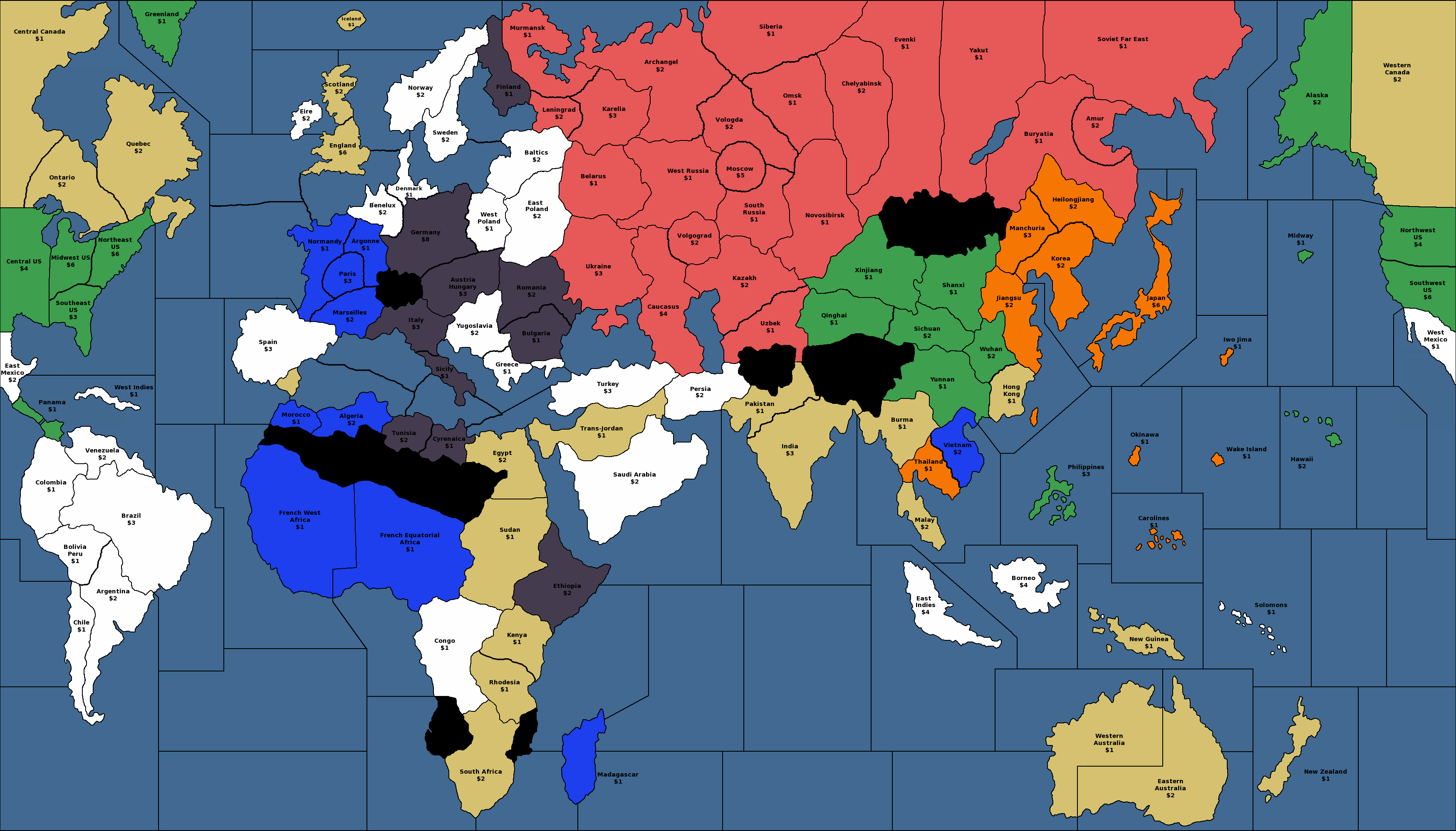
OK, here’s the second draft! Thanks again to everyone for all the helpful feedback.
Frederick II requested setup charts – is anyone else interested in seeing setup charts? If so, please vote up this comment or say so in a reply. If I get at least three people who want to see a setup chart, I’ll make one for 1939, and if I get at least five people, then I’ll make one for 1943, also.
Flashman, I just wanted to take a minute to acknowledge a couple of your suggestions that didn’t make it into this draft. You proposed a German port on the North Sea and a German enclave near Kaliningrad / Konigsburg. As a matter of history, you’re absolutely correct. The downside to adding in these tiny territories is that it further crowds a section of the map that is already very fiddly without doing much to enhance the available strategic options. In my opinion, the extra historical accuracy is not worth the price of having to crowd the soldiers in northern europe so closely together that they wind up knocking each other over. My philosophy for A&A in general, and this map in particular, is to try to maximize the strategic options while still respecting the fun-factor of seeing conflicts that at least remind us of conflicts from World War II. Some players prefer to get a simulation of history that’s as realistic as possible, and that’s fine, but that’s not what I’m trying to do here.
1939 map v2.png_thumb
1943 map v2.png_thumb
1939 map v2.png_thumb
1943 map v2.png_thumb
1939 map v2.png_thumb
1943 map v2.png_thumb
1939 map v2.png_thumb
1943 map v2.png_thumb
1939 map v2.png_thumb
1943 map v2.png_thumb
1939 map v2.png_thumb
1943 map v2.png_thumb
1939 map v2.png_thumb
1943 map v2.png_thumb
1939 map v2.png_thumb
1943 map v2.png_thumb
1939 map v2.png_thumb
1943 map v2.png_thumb
1939 map v2.png_thumb
1943 map v2.png_thumb
1939 map v2.png_thumb
1943 map v2.png_thumb
1939 map v2.png_thumb
1943 map v2.png_thumb
1939 map v2.png_thumb
1943 map v2.png_thumb
1939 map v2.png_thumb
1943 map v2.png_thumb
1939 map v2.png_thumb
1943 map v2.png_thumb
1939 map v2.png_thumb
1943 map v2.png_thumb
1939 map v2.png_thumb
1943 map v2.png_thumb
1939 map v2.png_thumb
1943 map v2.png_thumb
1939 map v2.png_thumb
1943 map v2.png_thumb
1939 map v2.png_thumb
1943 map v2.png_thumb
1939 map v2.png_thumb
1943 map v2.png_thumb
1939 map v2.png_thumb
1943 map v2.png_thumb
1939 map v2.png_thumb
1943 map v2.png_thumb
1939 map v2.png_thumb
1943 map v2.png_thumb
1939 map v2.png_thumb
1943 map v2.png_thumb
1939 map v2.png_thumb
1943 map v2.png_thumb
1939 map v2.png_thumb
1943 map v2.png_thumb
1939 map v2.png_thumb
1943 map v2.png_thumb
1939 map v2.png_thumb
1943 map v2.png_thumb
1939 map v2.png_thumb
1943 map v2.png_thumb
1939 map v2.png_thumb
1943 map v2.png_thumb
1939 map v2.png_thumb
1943 map v2.png_thumb
1939 map v2.png_thumb
1943 map v2.png_thumb
1939 map v2.png_thumb
1943 map v2.png_thumb
1939 map v2.png_thumb
1943 map v2.png_thumb
1939 map v2.png_thumb
1943 map v2.png_thumb
1939 map v2.png_thumb
1943 map v2.png_thumb
1939 map v2.png_thumb
1943 map v2.png_thumb
1939 map v2.png_thumb
1943 map v2.png_thumb
1939 map v2.png_thumb
1943 map v2.png_thumb
1939 map v2.png_thumb
1943 map v2.png_thumb
1939 map v2.png_thumb
1943 map v2.png_thumb
1939 map v2.png_thumb
1939 map v2.png_thumb
1939 map v2.png_thumb
1943 map v2.png_thumb
1939 map v2.png_thumb
1943 map v2.png_thumb
1939 map v2.png_thumb
1943 map v2.png_thumb
1939 map v2.png_thumb
1943 map v2.png_thumb
1939 map v2.png_thumb
1943 map v2.png_thumb
1939 map v2.png_thumb
1943 map v2.png_thumb
1939 map v2.png_thumb
1943 map v2.png_thumb
1939 map v2.png_thumb
1943 map v2.png_thumb
1939 map v2.png_thumb
1943 map v2.png_thumb
1939 map v2.png_thumb
1943 map v2.png_thumb
1939 map v2.png_thumb
1943 map v2.png_thumb
1939 map v2.png_thumb
1943 map v2.png_thumb
1939 map v2.png_thumb
1943 map v2.png_thumb
1939 map v2.png_thumb
1943 map v2.png_thumb
1939 map v2.png_thumb
1943 map v2.png_thumb
1939 map v2.png_thumb
1943 map v2.png_thumb
1939 map v2.png_thumb
1943 map v2.png_thumb
1939 map v2.png_thumb
1943 map v2.png_thumb
1939 map v2.png_thumb
1943 map v2.png_thumb
1939 map v2.png_thumb
1943 map v2.png_thumb
1939 map v2.png_thumb
1943 map v2.png_thumb
1939 map v2.png_thumb
1943 map v2.png_thumb
1939 map v2.png_thumb
1943 map v2.png_thumb
1939 map v2.png_thumb
1943 map v2.png_thumb
1939 map v2.png_thumb
1943 map v2.png_thumb
1939 map v2.png_thumb
1943 map v2.png_thumb
1939 map v2.png_thumb
1943 map v2.png_thumb
1939 map v2.png_thumb
1943 map v2.png_thumb
1939 map v2.png_thumb
1943 map v2.png_thumb
1939 map v2.png_thumb
1943 map v2.png_thumb
1939 map v2.png_thumb
1943 map v2.png_thumb
1939 map v2.png_thumb
1943 map v2.png_thumb
1939 map v2.png_thumb
1943 map v2.png_thumb
1939 map v2.png_thumb
1943 map v2.png_thumb
1939 map v2.png_thumb
1943 map v2.png_thumb
1939 map v2.png_thumb
1943 map v2.png_thumb
1939 map v2.png_thumb
1943 map v2.png_thumb
1939 map v2.png_thumb
1943 map v2.png_thumb
1939 map v2.png_thumb
1943 map v2.png_thumb
1939 map v2.png_thumb
1943 map v2.png_thumb
1939 map v2.png_thumb
1943 map v2.png_thumb
1939 map v2.png_thumb
1943 map v2.png_thumb
1939 map v2.png_thumb
1943 map v2.png_thumb
1939 map v2.png_thumb
1943 map v2.png_thumb
1939 map v2.png_thumb
1943 map v2.png_thumb
1939 map v2.png_thumb
1943 map v2.png_thumb
1939 map v2.png_thumb
1943 map v2.png_thumb
1939 map v2.png_thumb
1943 map v2.png_thumb
1939 map v2.png_thumb
1943 map v2.png_thumb
1939 map v2.png_thumb
1943 map v2.png_thumb
1939 map v2.png_thumb
1943 map v2.png_thumb
1939 map v2.png_thumb
1943 map v2.png_thumb
1939 map v2.png_thumb
1943 map v2.png_thumb
1939 map v2.png_thumb
1943 map v2.png_thumb
1939 map v2.png_thumb
1943 map v2.png_thumb
1939 map v2.png_thumb
1943 map v2.png_thumb
1939 map v2.png_thumb
1943 map v2.png_thumb
1939 map v2.png_thumb
1943 map v2.png_thumb
1939 map v2.png_thumb
1943 map v2.png_thumb
1939 map v2.png_thumb
1943 map v2.png_thumb
1939 map v2.png_thumb
1943 map v2.png_thumb
1939 map v2.png_thumb
1943 map v2.png_thumb
1939 map v2.png_thumb
1943 map v2.png_thumb
1939 map v2.png_thumb
1943 map v2.png_thumb
1939 map v2.png_thumb
1943 map v2.png_thumb
1939 map v2.png_thumb
1943 map v2.png_thumb
1939 map v2.png_thumb
1943 map v2.png_thumb
1939 map v2.png_thumb
1943 map v2.png_thumb
1939 map v2.png_thumb
1943 map v2.png_thumb
1939 map v2.png_thumb
1943 map v2.png_thumb
1939 map v2.png_thumb
1943 map v2.png_thumb
1939 map v2.png_thumb
1943 map v2.png_thumb
1939 map v2.png_thumb
1943 map v2.png_thumb
1939 map v2.png_thumb
1943 map v2.png_thumb
1939 map v2.png_thumb
1943 map v2.png_thumb
1939 map v2.png_thumb
1943 map v2.png_thumb
1939 map v2.png_thumb
1943 map v2.png_thumb
1939 map v2.png_thumb
1943 map v2.png_thumb
1939 map v2.png_thumb
1943 map v2.png_thumb
1939 map v2.png_thumb
1943 map v2.png_thumb
Hi Argothair,
nice job. But you should divide the East Indies and Borneo into two Islands each – Java & Sumatra and Borneo & Celebes – and maybe transfer the income from the smaller pacific islands to them.
In my opinion, the extra historical accuracy is not worth the price of having to crowd the soldiers in northern europe so closely together that they wind up knocking each other over. My philosophy for A&A in general, and this map in particular, is to try to maximize the strategic options while still respecting the fun-factor of seeing conflicts that at least remind us of conflicts from World War II. Some players prefer to get a simulation of history that’s as realistic as possible, and that’s fine, but that’s not what I’m trying to do here.
Since historical accuracy isn’t a map priority, is this also the case for geographic accuracy? If geography doesn’t matter, there’s presumably no need for people to provide feedback on geographic issues; however if it does matter, there are potentially some things that need revision. They don’t necessarily involve border changes (since you’ve said you don’t want to change your borders); some simply involve labeling changes. For example: the territory labeled “Persia” encompasses the territory of two separate countries and it would be more accurate to call it “Iraq / Persia”. Another example: “Pakistan” didn’t exist until 1947, so a different name (like “North-West India”) would be more accurate.
I just realized that you don’t have any seazones with any numbers. So are you planing something about that?
Could I vote for the setup? Or since I brought that up you want other people to vote.
CWO Marc, if it’s important to you, then I’ll change the names to Iraq / Persia and North-West India. Geography is part of how we know what we’re looking at, which adds to the fun factor. I’m willing to change borders, too, where that makes sense – I just don’t want to add lots of tiny territories where soldiers won’t fit. I did in fact change several borders in response to Flashman’s comments.
Frederick, you can vote, that’s fine. I’ll work on numbers for the sea zones.
Hessian, I could split up indonesia into four territories (five if you count Malay), but I don’t think it’s appropriate given the relatively low unit count I’m going to be aiming for on the setup – if I split up the islands, then Japan needs four transports to take Java, Celebes, Borneo and Sumatra in one turn, but with four loaded transports you could go crazy on the mainland, for example, land in Burma and take India on turn 2. As a compromise, I might just split “East Indies” into Java and Sumatra – there’s plenty of room in the sea zone, and it could be kind of cool to have two island territories in the same sea zone. That’s something other maps haven’t really done.
I’m not going to transfer the income from the small Pacific islands over to Indonesia, because I want to reward players for island-hopping across the Pacific.
CWO Marc, if it’s important to you, then I’ll change the names to Iraq / Persia and North-West India.
I was actually just trying to get a sense of whether those kinds of things are important to you. I wasn’t lobbying for you to change your map based on what I consider to be important; I simply wanted to get a better idea of what your own priorities were with regard to geographic accuracy.
I simply wanted to get a better idea of what your own priorities were with regard to geographic accuracy.
Fair enough; sorry if I laid a guilt trip on you.
The answer is that no, I don’t care much. I know where Iraq is and when Pakistan was founded, but I don’t feel any special need to show that on the map. The map is also missing Syria, Palestine, Czechoslovakia, Albania, Ceylon, Taiwan, Sakhalin, the Aleutian islands, Guatemala, Honduras, El Salvador, Uruguay, Paraguay, and Guyana, but I’m cool with that. I’m not sure the name “Kenya” was used until shortly after World War II, but, again, that’s OK with me. I’d rather use a name that contemporary people are familiar with and can relate to than a name that’s more historically accurate but more obscure, like Tanganyika.
Still don’t like “Greater Denmark”. Germany did have a north sea coast, and the Allies seriously considered invading Germany by this direct route.
Tunisia was a French colony; this would be more accurately called Tripolitania.
This arrangement of the Suez canal is another artefact from the original game; the canal runs through Egypt, not between Egypt and Jordan. This was finally corrected in A&A 1914.
The TT called Kenya here covers what was at the time referred to as British East Africa.
What you’ve called Rhodesia more closely corresponds to Tanganyika.
Karelia is the isthmus in the south of your Murmansk tt.
Hong Kong was not important militarily, I’d make this then Chinese province of Canton.
Gibraltar is another artefact, I prefer that UK can use the port there if Spain is neutral, but it’s not a land tt.
I’d suggest adding the Pripet marsh (impassable to armour/mech/art) in Russia.
I prefer a different arrangement of India, with the capital (New Delhi) as VC thus protected from invasion via Burma.
Viet Nam would be more authentically called “Indochina”.
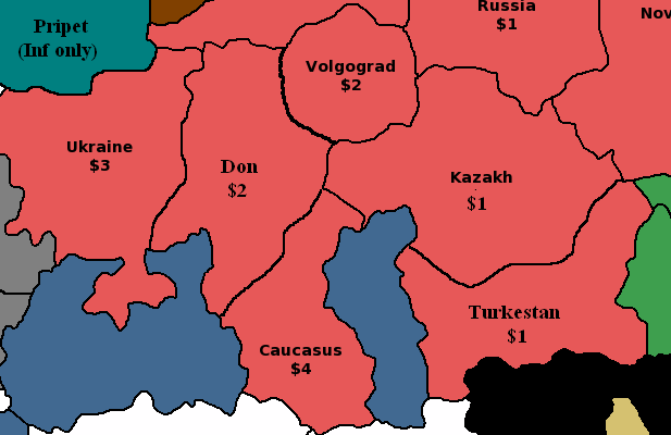
Germany never reached the oilfields of Baku, so I’d separate Caucasus from a northern “Don” region.
https://en.wikipedia.org/wiki/Case_Blue#/media/File:Eastern_Front_1942-05_to_1942-11.png
What is your evidence that the term Volgograd was used before 1961?
https://en.wikipedia.org/wiki/Volgograd_Oblast

India mod.PNG_thumb
India mod.PNG_thumb
DonTT.PNG_thumb
DonTT.PNG_thumb
DonTT.PNG_thumb
DonTT.PNG_thumb
DonTT.PNG_thumb
India mod1.PNG_thumb
DonTT.PNG_thumb
India mod1.PNG_thumb
DonTT.PNG_thumb
India mod1.PNG_thumb
DonTT.PNG_thumb
India mod1.PNG_thumb
DonTT.PNG_thumb
India mod1.PNG_thumb
DonTT.PNG_thumb
India mod1.PNG_thumb
DonTT.PNG_thumb
India mod1.PNG_thumb
DonTT.PNG_thumb
India mod1.PNG_thumb
DonTT.PNG_thumb
India mod1.PNG_thumb
DonTT.PNG_thumb
India mod1.PNG_thumb
DonTT.PNG_thumb
India mod1.PNG_thumb
DonTT.PNG_thumb
India mod1.PNG_thumb
DonTT.PNG_thumb
India mod1.PNG_thumb
DonTT.PNG_thumb
India mod1.PNG_thumb
DonTT.PNG_thumb
India mod1.PNG_thumb
DonTT.PNG_thumb
India mod1.PNG_thumb
DonTT.PNG_thumb
India mod1.PNG_thumb
DonTT.PNG_thumb
India mod1.PNG_thumb
DonTT.PNG_thumb
India mod1.PNG_thumb
DonTT.PNG_thumb
India mod1.PNG_thumb
DonTT.PNG_thumb
India mod1.PNG_thumb
DonTT.PNG_thumb
India mod1.PNG_thumb
DonTT.PNG_thumb
India mod1.PNG_thumb
DonTT.PNG_thumb
India mod1.PNG_thumb
DonTT.PNG_thumb
India mod1.PNG_thumb
DonTT.PNG_thumb
India mod1.PNG_thumb
DonTT.PNG_thumb
India mod1.PNG_thumb
DonTT.PNG_thumb
India mod1.PNG_thumb
DonTT.PNG_thumb
India mod1.PNG_thumb
DonTT.PNG_thumb
India mod1.PNG_thumb
DonTT.PNG_thumb
India mod1.PNG_thumb
DonTT.PNG_thumb
India mod1.PNG_thumb
DonTT.PNG_thumb
India mod1.PNG_thumb
DonTT.PNG_thumb
India mod1.PNG_thumb
DonTT.PNG_thumb
India mod1.PNG_thumb
DonTT.PNG_thumb
India mod1.PNG_thumb
DonTT.PNG_thumb
India mod1.PNG_thumb
DonTT.PNG_thumb
India mod1.PNG_thumb
DonTT.PNG_thumb
India mod1.PNG_thumb
DonTT.PNG_thumb
India mod1.PNG_thumb
DonTT.PNG_thumb
India mod1.PNG_thumb
DonTT.PNG_thumb
India mod1.PNG_thumb
DonTT.PNG_thumb
India mod1.PNG_thumb
DonTT.PNG_thumb
India mod1.PNG_thumb
DonTT.PNG_thumb
India mod1.PNG_thumb
DonTT.PNG_thumb
India mod1.PNG_thumb
DonTT.PNG_thumb
India mod1.PNG_thumb
DonTT.PNG_thumb
India mod1.PNG_thumb
DonTT.PNG_thumb
India mod1.PNG_thumb
DonTT.PNG_thumb
India mod1.PNG_thumb
DonTT.PNG_thumb
India mod1.PNG_thumb
DonTT.PNG_thumb
India mod1.PNG_thumb
DonTT.PNG_thumb
India mod1.PNG_thumb
DonTT.PNG_thumb
India mod1.PNG_thumb
DonTT.PNG_thumb
India mod1.PNG_thumb
DonTT.PNG_thumb
India mod1.PNG_thumb
DonTT.PNG_thumb
India mod1.PNG_thumb
DonTT.PNG_thumb
India mod1.PNG_thumb
DonTT.PNG_thumb
India mod1.PNG_thumb
DonTT.PNG_thumb
India mod1.PNG_thumb
DonTT.PNG_thumb
India mod1.PNG_thumb
DonTT.PNG_thumb
India mod1.PNG_thumb
DonTT.PNG_thumb
India mod1.PNG_thumb
DonTT.PNG_thumb
India mod1.PNG_thumb
DonTT.PNG_thumb
India mod1.PNG_thumb
DonTT.PNG_thumb
India mod1.PNG_thumb
DonTT.PNG_thumb
India mod1.PNG_thumb
DonTT.PNG_thumb
India mod1.PNG_thumb
DonTT.PNG_thumb
India mod1.PNG_thumb
India mod1.PNG_thumb
India mod1.PNG_thumb
India mod1.PNG_thumb
India mod1.PNG_thumb
India mod1.PNG_thumb
India mod1.PNG_thumb
India mod1.PNG_thumb
India mod1.PNG_thumb
India mod1.PNG_thumb
India mod1.PNG_thumb
India mod1.PNG_thumb
India mod1.PNG_thumb
India mod1.PNG_thumb
India mod1.PNG_thumb
India mod1.PNG_thumb
India mod1.PNG_thumb
India mod1.PNG_thumb
India mod1.PNG_thumb
India mod1.PNG_thumb
India mod1.PNG_thumb
India mod1.PNG_thumb
India mod1.PNG_thumb
India mod1.PNG_thumb
India mod1.PNG_thumb
India mod1.PNG_thumb
India mod1.PNG_thumb
India mod1.PNG_thumb
India mod1.PNG_thumb
India mod1.PNG_thumb
India mod1.PNG_thumb
India mod1.PNG_thumb
India mod1.PNG_thumb
India mod1.PNG_thumb
India mod1.PNG_thumb
India mod1.PNG_thumb
India mod1.PNG_thumb
India mod1.PNG_thumb
India mod1.PNG_thumb
India mod1.PNG_thumb
India mod1.PNG_thumb
India mod1.PNG_thumb
India mod1.PNG_thumb
India mod1.PNG_thumb
India mod1.PNG_thumb
India mod1.PNG_thumb
India mod1.PNG_thumb
India mod1.PNG_thumb
India mod1.PNG_thumb
India mod1.PNG_thumb
India mod1.PNG_thumb
India mod1.PNG_thumb
India mod1.PNG_thumb
India mod1.PNG_thumb
India mod1.PNG_thumb
India mod1.PNG_thumb
India mod1.PNG_thumb
India mod1.PNG_thumb
India mod1.PNG_thumb
India mod1.PNG_thumb
India mod1.PNG_thumb
India mod1.PNG_thumb
India mod1.PNG_thumb
India mod1.PNG_thumb
India mod1.PNG_thumb
India mod1.PNG_thumb
India mod1.PNG_thumb
India mod1.PNG_thumb
India mod1.PNG_thumb
India mod1.PNG_thumb
India mod1.PNG_thumb
India mod1.PNG_thumb
India mod1.PNG_thumb
India mod1.PNG_thumb
India mod1.PNG_thumb
India mod1.PNG_thumb
India mod1.PNG_thumb
India mod1.PNG_thumb
India mod1.PNG_thumb
India mod1.PNG_thumb
India mod1.PNG_thumb
India mod1.PNG_thumb
India mod1.PNG_thumb
India mod1.PNG_thumb
India mod1.PNG_thumb
India mod1.PNG_thumb
India mod1.PNG_thumb
India mod1.PNG_thumb
India mod1.PNG_thumb
India mod1.PNG_thumb
India mod1.PNG_thumb
India mod1.PNG_thumb
India mod1.PNG_thumb
India mod1.PNG_thumb
India mod1.PNG_thumb
India mod1.PNG_thumb
India mod1.PNG_thumb
India mod1.PNG_thumb
India mod1.PNG_thumb
India mod1.PNG_thumb
India mod1.PNG_thumb
India mod1.PNG_thumb
India mod1.PNG_thumb
India mod1.PNG_thumb
India mod1.PNG_thumb
India mod1.PNG_thumb
India mod1.PNG_thumb
India mod1.PNG_thumb
India mod1.PNG_thumb
India mod1.PNG_thumb
India mod1.PNG_thumb
India mod1.PNG_thumb
India mod1.PNG_thumb
India mod1.PNG_thumb
India mod1.PNG_thumb
India mod1.PNG_thumb
India mod1.PNG_thumb
India mod1.PNG_thumb
India mod1.PNG_thumb
India mod1.PNG_thumb
India mod1.PNG_thumb
India mod1.PNG_thumb
India mod1.PNG_thumb
India mod1.PNG_thumb
India mod1.PNG_thumb
India mod1.PNG_thumb
India mod1.PNG_thumb
India mod1.PNG_thumb
Frederick, you can vote, that’s fine. I’ll work on numbers for the sea zones.
Ok than I vote +1 up.
From an overall map design standpoint, the important thing is that you find the basic territory connections that you like first, because there are definite limits to what you can do in terms of “geographical accuracy” when using such an abstracted baseline map projection.
Just to be clear, I didn’t draw that Revised/1942.2 baseline for tripleA. In fact it was my frustration with tripleA’s Revised map, that made me start wanting to draw a better A&A map in the first place.
I rather liked Logan’s Classic map for tripleA, but the Revised map always got under my skin hehe. I’m not sure who put it together, it may have been Logan, but I couldn’t say for sure. Alas, Revised was the most popular TripleA game at the time, and when Spring 1942, and 1942 second edition came out, the same basic baseline was used, I guess for familiarity. But I was never a fan of that particular design.
It used way too much “Blob” and “jiggery borders” for my taste. The sort of thing that a history teacher might draw on a chalkboard from memory… good enough to get the point across, but totally abstracted and wonky when put up against an image of the real world.
On the other hand, mercator is equally ill-suited to the task, since in Mercator all the important areas for A&A gameplay are way too small, and all the irrelevant areas are way too large!
I much preferred the AA50 design in tripleA (since I drew it, I’m obviously biased haha) which was intended as a compromise. I actually posted a lot of different ideas on the Larry boards, for possible projections that would be more accurate yet still accommodate the gameplay. Global was an improvement, but it still utilizes the “blob effect” much more than I’d like.
All OOB Axis and Allies maps do 2 things which make Geographical accuracy difficult:
First, they englarge Europe and the Asia/Pacific region.
And second, they shrink everywhere else on the globe!
This creates what I’ve called the “center squeeze” or the “center squish.” :-D
If you imagine stretching and bending the image of the globe so that Europe and the Asia/Pacific region are basically twice their normal size, while simultaneously contorting the Americas and Africa so they are reduced to half their normal size, you can start to see why the “blob effect” constantly reappears in A&A. Because if you don’t blob things out, the world itself and all the national borders start to become totally unrecognizable. Shaky border lines are necessary, because none of the rivers or mountains or cities or other guideposts you might use, end up where they should be, when you blow Europe out to the necessary size to house sculpts. It’s a bind for sure.
A&A maps tend to exploit the fact that most people have no idea what some obscure central Russian territory actually looks like, or where it’s supposed to be in relation to all the other obscure central Russian territories. So you can move Moscow like a couple thousand miles east of where it is in reality, and nobody bats an eye. Because in Classic and Revised, they’re all just big blobs anyway. Once you start trying to divide things up into more nuanced regions though, things get tricky.
Basically, the whole center area of the game map is a wonky hodgepodge of distortions. The Middle East, India, China, and pretty much all of Russia, don’t really align the way they would if the world was presented to scale. Add to that the need for a huge Mediterranean sea (to fit all those ship sculpts) and this is basically what we’re up against.
The closest I ever got to something that seemed relatively accurate, yet still scaled so that it might be playable for A&A was this map below. But there are way more territories than you’d need. The reason I drew it this way was so borders could be erased and collapsed to form larger territories, rather than blobbed in at random. So here at least, if you want to find a place like Saxony, or if you want to know where the Elbe is or the Don, or where that would be in relation to the Danube or the Volga, you can kind of follow an outline that roughly matches the political map of a Mercator projection.
Clearly there is still a lot of distortion, but at least you can kind of work through it when you look at the territory tiles relative to each other.
My advice would be to find territory connections that you think would be enjoyable for the gameplay (using whatever map you like, the 1942.2 one above say). Then, once you have the connections you like, you can port those into a map projection more like this one, collapsing and erasing lines where necessary so it matches your gameplay vision, and then give the territories whatever names would make sense for the regions they end up encompassing. ;)
Basically to take the guess work out of it, since the territory shapes here should fit the puzzle of the actual globe (unlike the territory tiles on TripleA’s Revised map or the 1942.2 map which grew out of it, which are both pretty random). Erase whatever is unnecessary (islands, regions, whatever, until it fits the scope you’re after.) Expand the Oceans if desired, since its all just the same color blue and mostly empty space (aside from a few islands that are fairly easy to shimmy around, or eliminate or redraw), you can pretty much make the Oceans as wide as you like.
Then you just double or triple the scale of the baseline map, so that it’s large enough for your game, and give the territories a border graphic, a nice clean border. One that is larger than the 1 pixel line here, so it looks decent when you print it out. Add in some skins or relief graphics, if desired, and you’re basically good to go.
:-D
World_Map_Jason_Clark.png_thumb
World_Map_Jason_Clark.png_thumb
World_Map_Jason_Clark.png_thumb
World_Map_Jason_Clark.png_thumb
World_Map_Jason_Clark.png_thumb
World_Map_Jason_Clark.png_thumb
World_Map_Jason_Clark.png_thumb
World_Map_Jason_Clark.png_thumb
World_Map_Jason_Clark.png_thumb
World_Map_Jason_Clark.png_thumb
World_Map_Jason_Clark.png_thumb
World_Map_Jason_Clark.png_thumb
World_Map_Jason_Clark.png_thumb
World_Map_Jason_Clark.png_thumb
World_Map_Jason_Clark.png_thumb
World_Map_Jason_Clark.png_thumb
World_Map_Jason_Clark.png_thumb
World_Map_Jason_Clark.png_thumb
World_Map_Jason_Clark.png_thumb
World_Map_Jason_Clark.png_thumb
World_Map_Jason_Clark.png_thumb
World_Map_Jason_Clark.png_thumb
World_Map_Jason_Clark.png_thumb
World_Map_Jason_Clark.png_thumb
World_Map_Jason_Clark.png_thumb
World_Map_Jason_Clark.png_thumb
World_Map_Jason_Clark.png_thumb
World_Map_Jason_Clark.png_thumb
World_Map_Jason_Clark.png_thumb
World_Map_Jason_Clark.png_thumb
World_Map_Jason_Clark.png_thumb
World_Map_Jason_Clark.png_thumb
World_Map_Jason_Clark.png_thumb
World_Map_Jason_Clark.png_thumb
World_Map_Jason_Clark.png_thumb
World_Map_Jason_Clark.png_thumb
World_Map_Jason_Clark.png_thumb
World_Map_Jason_Clark.png_thumb
World_Map_Jason_Clark.png_thumb
World_Map_Jason_Clark.png_thumb
World_Map_Jason_Clark.png_thumb
World_Map_Jason_Clark.png_thumb
World_Map_Jason_Clark.png_thumb
World_Map_Jason_Clark.png_thumb
World_Map_Jason_Clark.png_thumb
World_Map_Jason_Clark.png_thumb
World_Map_Jason_Clark.png_thumb
World_Map_Jason_Clark.png_thumb
World_Map_Jason_Clark.png_thumb
World_Map_Jason_Clark.png_thumb
World_Map_Jason_Clark.png_thumb
World_Map_Jason_Clark.png_thumb
World_Map_Jason_Clark.png_thumb
World_Map_Jason_Clark.png_thumb
World_Map_Jason_Clark.png_thumb
World_Map_Jason_Clark.png_thumb
World_Map_Jason_Clark.png_thumb
World_Map_Jason_Clark.png_thumb
World_Map_Jason_Clark.png_thumb
World_Map_Jason_Clark.png_thumb
World_Map_Jason_Clark.png_thumb
World_Map_Jason_Clark.png_thumb
World_Map_Jason_Clark.png_thumb
World_Map_Jason_Clark.png_thumb
World_Map_Jason_Clark.png_thumb
World_Map_Jason_Clark.png_thumb
World_Map_Jason_Clark.png_thumb
World_Map_Jason_Clark.png_thumb
World_Map_Jason_Clark.png_thumb
World_Map_Jason_Clark.png_thumb
World_Map_Jason_Clark.png_thumb
World_Map_Jason_Clark.png_thumb
World_Map_Jason_Clark.png_thumb
World_Map_Jason_Clark.png_thumb
World_Map_Jason_Clark.png_thumb
World_Map_Jason_Clark.png_thumb
World_Map_Jason_Clark.png_thumb
World_Map_Jason_Clark.png_thumb
World_Map_Jason_Clark.png_thumb
World_Map_Jason_Clark.png_thumb
World_Map_Jason_Clark.png_thumb
World_Map_Jason_Clark.png_thumb
World_Map_Jason_Clark.png_thumb
World_Map_Jason_Clark.png_thumb
World_Map_Jason_Clark.png_thumb
World_Map_Jason_Clark.png_thumb
World_Map_Jason_Clark.png_thumb
World_Map_Jason_Clark.png_thumb
World_Map_Jason_Clark.png_thumb
World_Map_Jason_Clark.png_thumb
World_Map_Jason_Clark.png_thumb
World_Map_Jason_Clark.png_thumb
World_Map_Jason_Clark.png_thumb
World_Map_Jason_Clark.png_thumb
World_Map_Jason_Clark.png_thumb
World_Map_Jason_Clark.png_thumb
World_Map_Jason_Clark.png_thumb
World_Map_Jason_Clark.png_thumb
World_Map_Jason_Clark.png_thumb
World_Map_Jason_Clark.png_thumb
World_Map_Jason_Clark.png_thumb
World_Map_Jason_Clark.png_thumb
World_Map_Jason_Clark.png_thumb
World_Map_Jason_Clark.png_thumb
World_Map_Jason_Clark.png_thumb
World_Map_Jason_Clark.png_thumb
World_Map_Jason_Clark.png_thumb
World_Map_Jason_Clark.png_thumb
World_Map_Jason_Clark.png_thumb
World_Map_Jason_Clark.png_thumb
World_Map_Jason_Clark.png_thumb
World_Map_Jason_Clark.png_thumb
World_Map_Jason_Clark.png_thumb
World_Map_Jason_Clark.png_thumb
World_Map_Jason_Clark.png_thumb
World_Map_Jason_Clark.png_thumb
World_Map_Jason_Clark.png_thumb
World_Map_Jason_Clark.png_thumb
World_Map_Jason_Clark.png_thumb
World_Map_Jason_Clark.png_thumb
World_Map_Jason_Clark.png_thumb
World_Map_Jason_Clark.png_thumb
World_Map_Jason_Clark.png_thumb
World_Map_Jason_Clark.png_thumb
World_Map_Jason_Clark.png_thumb
World_Map_Jason_Clark.png_thumb
World_Map_Jason_Clark.png_thumb
World_Map_Jason_Clark.png_thumb
World_Map_Jason_Clark.png_thumb
World_Map_Jason_Clark.png_thumb
World_Map_Jason_Clark.png_thumb
World_Map_Jason_Clark.png_thumb
World_Map_Jason_Clark.png_thumb
World_Map_Jason_Clark.png_thumb
World_Map_Jason_Clark.png_thumb
World_Map_Jason_Clark.png_thumb
World_Map_Jason_Clark.png_thumb
World_Map_Jason_Clark.png_thumb
World_Map_Jason_Clark.png_thumb
World_Map_Jason_Clark.png_thumb
World_Map_Jason_Clark.png_thumb
World_Map_Jason_Clark.png_thumb
World_Map_Jason_Clark.png_thumb
World_Map_Jason_Clark.png_thumb
World_Map_Jason_Clark.png_thumb
World_Map_Jason_Clark.png_thumb
World_Map_Jason_Clark.png_thumb
World_Map_Jason_Clark.png_thumb
World_Map_Jason_Clark.png_thumb
World_Map_Jason_Clark.png_thumb
World_Map_Jason_Clark.png_thumb
World_Map_Jason_Clark.png_thumb
World_Map_Jason_Clark.png_thumb
World_Map_Jason_Clark.png_thumb
World_Map_Jason_Clark.png_thumb
World_Map_Jason_Clark.png_thumb
World_Map_Jason_Clark.png_thumb
World_Map_Jason_Clark.png_thumb
World_Map_Jason_Clark.png_thumb
World_Map_Jason_Clark.png_thumb
World_Map_Jason_Clark.png_thumb
World_Map_Jason_Clark.png_thumb
World_Map_Jason_Clark.png_thumb
World_Map_Jason_Clark.png_thumb
World_Map_Jason_Clark.png_thumb
World_Map_Jason_Clark.png_thumb
World_Map_Jason_Clark.png_thumb
World_Map_Jason_Clark.png_thumb
World_Map_Jason_Clark.png_thumb
World_Map_Jason_Clark.png_thumb
World_Map_Jason_Clark.png_thumb
World_Map_Jason_Clark.png_thumb
World_Map_Jason_Clark.png_thumb
World_Map_Jason_Clark.png_thumb
World_Map_Jason_Clark.png_thumb
World_Map_Jason_Clark.png_thumb
World_Map_Jason_Clark.png_thumb
World_Map_Jason_Clark.png_thumb
World_Map_Jason_Clark.png_thumb
World_Map_Jason_Clark.png_thumb
World_Map_Jason_Clark.png_thumb
World_Map_Jason_Clark.png_thumb
World_Map_Jason_Clark.png_thumb
World_Map_Jason_Clark.png_thumb
World_Map_Jason_Clark.png_thumb
World_Map_Jason_Clark.png_thumb
World_Map_Jason_Clark.png_thumb
World_Map_Jason_Clark.png_thumb
World_Map_Jason_Clark.png_thumb
World_Map_Jason_Clark.png_thumb
World_Map_Jason_Clark.png_thumb
World_Map_Jason_Clark.png_thumb
It’s true that A&A maps (and A&A-type maps from other games) always include distortions, with diffent areas being shrunk or expanded or re-proportioned. Different maps, however, do it to varying degrees. In the Global 1940 map, for instance, Africa is about twice as wide as it’s tall – but in this map…
http://www.boardgamegeek.com/image/672203/wwii-struggle-europe-and-asia?size=large
…it’s three or perhaps even four times wider than it’s tall, which to me at least makes the continent unrecognizable. Generally speaking I quite like the Global 1940 map, both because of its semi-topographical look and because the distortions it contains are (speaking very generally, and acknowledging that there are exceptions) distortions of size rather than distortions of shape. South America, for example, is much too small relative to Africa, but its overall shape is pretty accurate.
From a game-map perspective, two big problems with the real world are that it’s spherical (meaning that any flat map will include distortions due to projection requirements) and that it contains both an awful lot of “wasted” space and an awful lot of “crowded” space. The Pacific Ocean is an obvious example of wasted space: it’s mostly empty, yet it covers about one-third of the world’s surface. A similar but less obvious problem is that most of the world’s land masses are located in the northern hemisphere, which contains all of North America and Europe, virtually all of Asia (the world’s largest continent, with 30% of Earth’s land area), and more than half of Africa. The only appreciable land masses below the Equator are the majority of South America, the lower section of Africa, and all of Australia, New Zealand and Antarctica; the rest of the southern hemisphere is mostly water.
Some of the world’s land areas have the opposite problem: they’re too crowded. The land area running west-to-east from France to the Volga and north-to-south from the Baltic coast to the Mediterranean coast is tiny on a proper world map, or on a globe, but most of the fighting in WWII (if you go by troop numbers and by military and civilian casualties) took place there. Since cramming that much action into a space that small is clearly impractical for game-mapping purposes, the tempting solution is to shrink the “wasted” mostly-empty parts of the world and to use the saved space to expand the “crowded” parts of the world where you need to deploy lots of troops and equipment. I think it’s a valid approach as long as one doesn’t go overboard and take the distortions too far (especially the distortions of shape, which I think are more problematic than distortions of size).
One side-effect, however, is what I’d call “cartographic determinism” – choosing what areas to expand (or even depict outright) and which ones to shrink (or even eliminate altogether) based on retroactive knowledge of where the major actions of WWII were actually fought (as opposed to where they might have been fought). For example, the Pacific 1940 map doesn’t mention Yap (which has a land area of 100 square kilometers) but it does mention Iwo Jima (which has a land area of just 21 square kilometers) because the latter was the site of a major amphibious campaign while the former was not. The Europe 1940 map allocates lots of space to northern Africa because of the Desert Campaign that was fought there, and little room to southern Africa because no land battles were fought there. Likewise, the map divides the country of Libya into two map territories: “Libya” to the west and “Tobruk” to the east. This east-west division has some geographic validity, since Libya did used to have three administrative divisions (Tripolitania in the northwest, Fezzan in the southwest, and Cyrenaica in the east), but the labeling reflects the events of WWII: Cyrenaica is called “Tobruk” because Tobruk – which is actually just a port city – was the site of major battles. And so forth. These are valid design decisions, but in a sense theymight subconsciously “channel” players into replicating the course of WWII as it was actually fought rather than leaving them more open to alternate courses of action.

