


@lt-dan well if you have any interest in adding the fascist Italy symbol and city territories later to create a new additional map let me know! I will likely grab your G40 board but would be interested in a hbg 36 style board but for g40 if you decide to make one.
Custom Map
-
When I upload to dropbox it doesn’t allow a preview. Do you want me to share the link for you to download it?
-
When I upload to dropbox it doesn’t allow a preview. Do you want me to share the link for you to download it?
Just send the link for download or use something like mediafire to host you image on the internet.
-
Just after I posted my message I noticed you had a single post with a large image that linked to postimages where I could see a large image 10.000 pixels wide. That worked flawlessly, but now the post is gone…
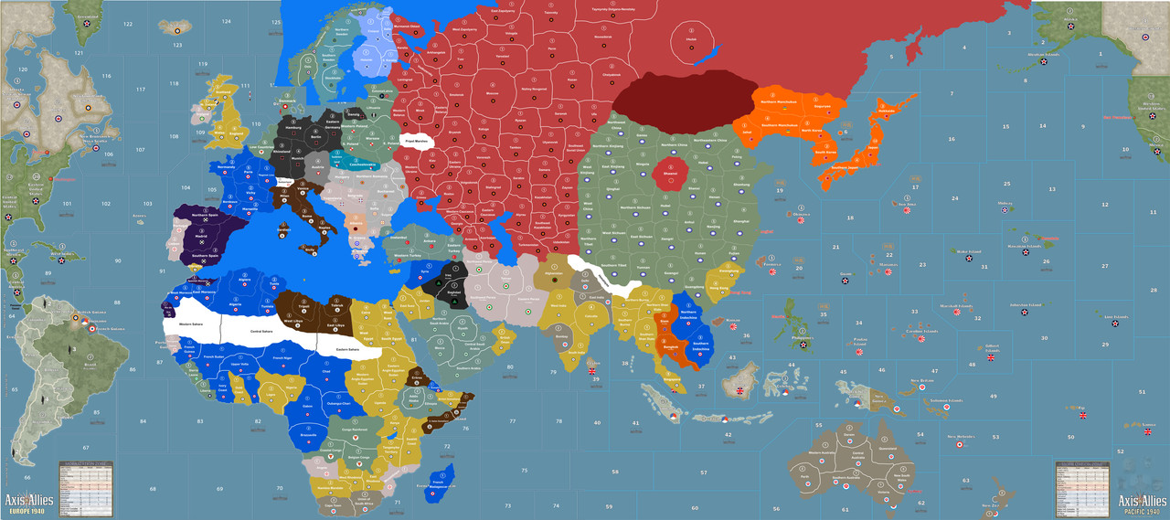
Nevertheless this map will become HUGE in the number of territories. China alone seems over 30 territories! How long do you expect this game will take to play? :-D
-
This was the biggest file I could get with the best quality.
Here is the dropbox link to the file you can download.
-
I was testing picture sizes. Didn’t realize one worked, I reposted it. Also I forgot to actually attach the dropbox link, here it is
https://www.dropbox.com/home?preview=My+Map.afdesignWhen looking at time, it is expected to be a long game. One that will take multiple sessions to finish (G1940 does anyways with how our group works so this won’t change much of our game play). It is meant to encourage different strategies
-
Through this game we will be using the basic mechanics of axis and allies, but with more advanced features. Including new rules that will allow for neutral country invasions, more advanced tech, and possibly a diplomatic feature (this is up in the air as it may open too many doors).
-
This project is still underway. Between graduating from one school, starting grad school immediately after, and it being prime backpacking and climbing season I have been very busy. All that is left is dividing up territories on the Americas on the Europe side of the board and dividing up sea zones
-
Very little progress has been made on the game mechanics as I am waiting for pieces at HBG to be in stock before I get down to the details of things
-
@P@nther:
…
With Affinity Publisher they will offer a replacement for Adobe Indesign anytime this year.Hadn’t heard of Publisher.
Thanks for the heads up.
Publisher is in beta status now. You can download it for free for testing purposes:
-
Bgugs… you do know that’s based on the map i made?
-
Yes IL I contacted you via pm a while back about this you said it was fine as long as I wasn’t making money on it and as long as I gave you credit if I have a credit section on the map. Not making any money and as of now there is no credit section
-
ok then
-
Hi I was wondering if I get a copy of you map. I’m in the process of editing map files to create a 1939 global map.
If you don’t mind can you send it to [email protected]
Regards
Morris Caldarola -
@Johnson73 I too would like to hop on the train and for a file, your map looks great
-
Hey guys. I can attach a file of the uncompleted map if you would like. However, I have been completing a one years masters program while getting my teaching certificate this last year. Because of this the Americas on the Europe side of the map are not completed nor are the sea zones. I am hoping to have time to restart and finish this project by December. With my masters ending in August and being a first year teacher this may be optimistic but most of the work is done so I think I can do it. Sorry for the late response, I have very little free time these days. But let me know if you want an incomplete one or an email when it is complete.
-
Gimp -> Photo editing
GIMP excels at editing pixel based pictures. If you have pixel-based elements in your design (idk., photos, hand-drawn stuff, etc.), then I’d use GIMP to prepare those.
Inkscape -> illustration and logos and simple text layout.
Inkscape does vector graphics, which is great for print media. I use it for making publication quality figures. eg. Setting fonts, doing layouts, or making cartoons.
I used a XP-Pen Star 03 ( https://www.xp-pen.com/product/44.html ) graphics tablet work with GIMP and Inkscape , it was the large size. Great tablet lasted me for about 3 years until I got my Artist 15.6 Pro pen display tablet .
-
hey guys, sooo i made this the last couple months and wanted to get you’re guys opinion on this one.

(yes i used the photo of sireblood’s map for showing purpose cause i ain’t got the money to print the map.)just let me know what you think so far.
-
The look reminds me of Man in the High Castle style map and i love it!
-
feel free to say im wrong but i was interested in making an napoleonic themed axis and allies era board i have an idea how the rules will work and units will function but have no clue as far as designing digital stuff
-
Runny you bring that up. I made such a game back in 2006 called Napoleonic Wars ( used name before GMT’s game of the same title). I just placed an order for full Fighting Sail ships from old glory to represent the primary ships that fought. My system uses basic Infantry, Cavalry, Artillery, and two types of ships ( 1st rate SOL and 2nd rate and lower SOL). The combat system is artillery fire first, remove loses> Cavalry fires second, remove loses, Then infantry. Infantry can “square” as a defense against attacking cavalry ( that invalidates them so they fire with infantry in combat sequence). If they do this, the infantry defend at -1. Generals are in the game and forts. Weather also plays its role.
I will start to update this game after a tournament as i also need to send the minis for painting.
Suggested Topics

