


End of turn 3. Things are just starting to get going.
image1(23).png
So I’m running into some difficulty, and I’m open to advice. At this point the map file is a .png file, as required for the TripleA map editor utilities; it’s not a vector file. That means that I can’t easily expand the size of the map (in pixels) while keeping the borders one-pixel wide, as required by the utilities.
Unfortunately, many of the smaller territories are not wide enough to accommodate even one or two unit types – the units are 35 pixels wide, so even though the map as a whole is several thousand pixels wide, smaller territories like Greece, Malta, Denmark, Kiev, etc. are just not capable of displaying a mixed army without spilling over way into other territories in a horrible mess. It’s not just one or two territories, and if I merged all of the smaller territories then this map would no longer faithfully represent my vision.
How have other map designers tackled this problem? Anyone have any creative ideas? I could start from scratch with a new vector file, but I would lose dozens of hours of work, even if I used this map as sort of a sketch to guide me.
I have very little knowledge of the graphics part. You might want to ask at the triplea site
https://forums.triplea-game.org/category/28/map-making
For some reason I want to say that units are usually 24x24 but I’m not certain about that. Also you can reverse the direction of the overflow if it’s less crowded going the other way.
Its not particularly easy. One of the reason I frequently reused sections of my world map for different projects is just because it took so damn long to redraw everything at scale initially and then rescaling is a pain. Your best bet is to double the scale to try and go from a 1 pixel border to a 2-3 pixel border when it rescales. When a raster graphics file like the one tripleA needs goes up or down in size, the shape of the line will change because you can’t recolor/fade the line to preserve the shape. The map can still function and there are ways to clean stuff up using map skins/details. See any of the tripleA maps based on Domination to get a sense for what that looks like. The map in that case will still usually still look reasonably good if players are running at a 50% zoom, though sometimes text can get harder to read and it may get some fuzz at different scales.
Otherwise you may be able to do more in Photoshop or Gimp by isolating the color (in this case black or white/blue) and expanding or isolating by 1 pixel. But you will almost certainly have to redraw something going that route, since it will give you gaps or chunky spots.
Basically this is one of the things that holds tripleA back as a game engine. There’s a lot you can do in tripleA, bit drawing/rescaling baselines is kinda stuck with what it is.
You might ask Frostion or Hepps about the tricks they use with map details to polish the borders. There are visual ways to soften things up so its not as pronounced.
Thanks for the tips, both of you! Just to be clear, I’m not worried at this point about the visual prettiness of the lines…I just need the lines to be thin enough and crisp enough that the Polygon Grabber can accurately identify territories.
@Argothair, put me down for helping in general with playtesting, naming territories, and GIMP/art stuff. What help do you need right now?
I just want to make sure that you know that Inkscape (free/open-source illustrator clone) can quickly and awesomely vectorize raster images- I’ve attached your map, vectorized as a pdf below (this took literally 5 minutes; you can endlessly tweak/refine the process, exclude text, etc…). You’re probably already aware- I just want to make sure. This obviously doesn’t instantly solve your 1-pixel-wide problems.
I think the Azores in the Atlantic has an expansive effect on Axis mental health (and strategic bombing strategies); what about in one of the two spots shown below?
@Black_Elk playing the POS map with the islands between SZs was just a massive eye-opener. I modified community maps and printed big physical POS & POS+C maps, and I taped your islands to my revised board- my group played 10 or 20 in-person games between 2006-2009 on those setups! So much crunchier tactically, especially in the Mediterranean and PTO, and the initial unit placements were so refreshing.
Top Azores is almost right. Same sz but move it more north and also be added maybe action if it was touching both sz. Mine is like that. I have uK convoy boxes out by Azores. Could place for either side to have plane support or sub attacks. Plus I know not interested but Azores is one of my influence strict neutral.
Hitler wanted to bomb Washington from there or close to it or naval ports
@SS-GEN said in Argo's Middleweight Map for 1939 & 1942:
Top Azores is almost right. Same sz but move it more north
I Northed the Azores. I think it would be fun to put them at the center of an intersection, would take some rejiggering. No clue how that affects atlantic flow.
I post pic of my map I use. You’ll see. For my game the battle of the Atlantic can go on for 6 turns. Be tough for this probably without changing setup a bit. But it’s just ideas u can store down the road for other games or to play around with. Depends on what convoy rules are being used.

Here’s a pic of my setup in Atlantic. Disreguard Europe. There’s 3 more German subs not in pic. ! by Iceland, 1 by Norway and 1 in the Baltic. 13 total. So if a sub goes inside a convoy box it cost country that many ICPs against income and for every one sub touching the outside of a convoy box its another 1 Icp income lose.
There’s also another UK convoy box worth 2 not in pick at top of map and a Russian convoy box down below out of pick worth 4 by just east of Iceland.
Just some ideas if interested for other games.
I think we killed @Argothair’s thread with our Azorian chatter, @SS-GEN.
@vodot I don’t think so. I would believe he’s busy. I heard he’s not going to Siredbloods tourney this weekend.
@SS-GEN Yup, I’m just really busy. I’ll come back eventually!
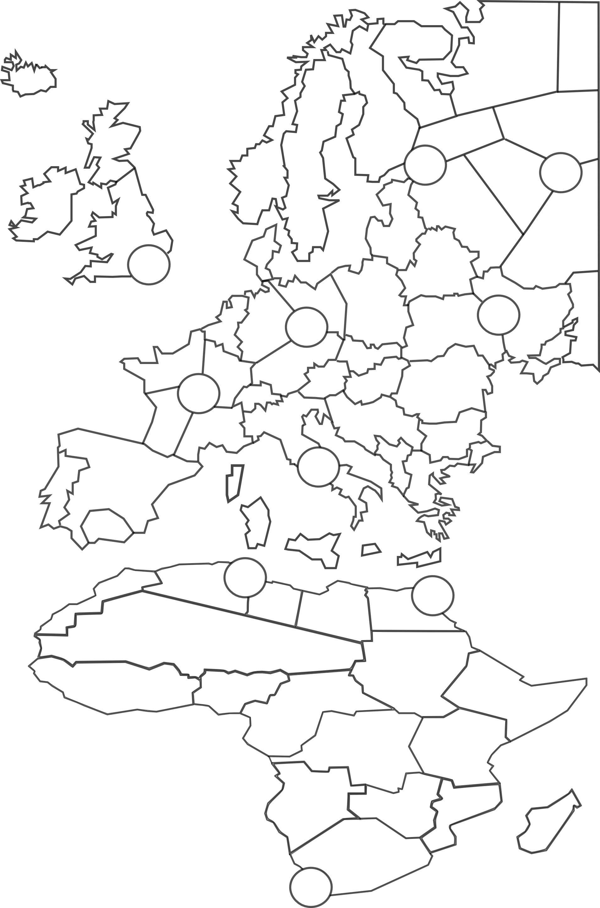
Update: I decided to manually trace a brand new vector map so that I can squash and enlarge continents as I see fit and then rescale when I’m done so that the smallest tiles will still be enough pixels wide to hold a few unit types each. Here’s Europe and Africa – you may notice that Africa is only half the height it ‘should’ be compared to Europe, and that the UK is about 140% of its proper size, and that the English Channel and North Sea are about triple their proper sizes. I plan to continue abusing geography for our wargaming convenience until I’ve finished the whole globe. This project is taking several years longer than I originally anticipated, but I do not plan to quit. Thanks again for all your support. :)
@Argothair said in Argo's Middleweight Map for 1939 & 1942:
This project is taking several years longer than I originally anticipated, but I do not plan to quit.
It’s nice to have a hobby :)
Is it possible to get TripleA to allow transports to move or unload only during noncombat? I was thinking it might be interesting to have two kinds of boats that move land units:
This would make it very challenging to win a beachhead, but very easy to reinforce a beachhead once you’ve got one – you could even follow up the same turn, e.g., landing craft to get from London to Normandy, and then if you actually capture Normandy then maybe transports can unload some tanks into Normandy from Canada or even New York during the non-combat phase of the same turn.
I’d like to find out if this is possible before finishing my sea zones.
@Argothair said in Argo's Middleweight Map for 1939 & 1942:
Is it possible to get TripleA to allow transports to move or unload only during noncombat? I was thinking it might be interesting to have two kinds of boats that move land units:
- Transports, which move 3, carry any 3 land units, and can only unload during noncombat
- Landing Craft, which move 1, carry 1 infantry, bombard at 1, and can load/unload at any time.
Hmm…yea i think you can. You need to use this for the non combat one. It should work, but … ? I can’t remember ever using it so idk for sure :)
<option name=“canNotMoveDuringCombatMove” value=“true”/>
Thanks! I’ll give it a try and let you know. :)
And I bet it does work; I bet that’s the same option that’s used for the AAA guns.
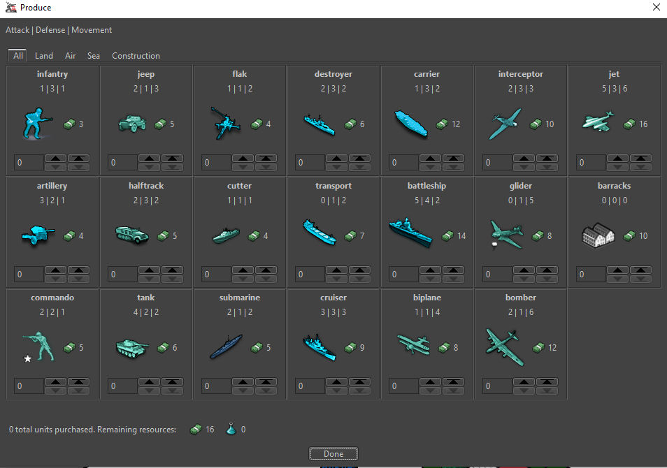
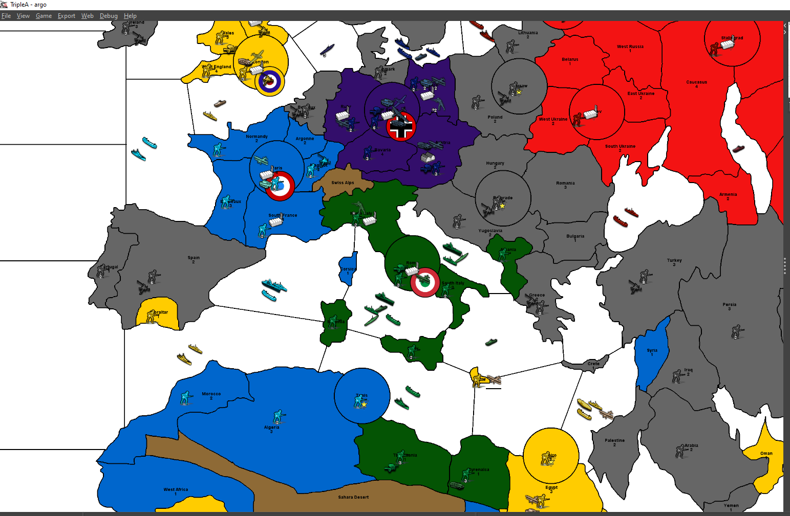
Progress continues. The circles (victory cities) are 180 pixels wide, which means that every territory should have plenty of room to host a reasonable number of units.

I’ve got a reasonably functional prototype in TripleA again with the new map – here’s the unit list:
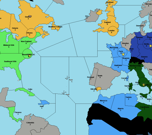
And here’s a snapshot of the European theater of operations – as you can see, the units are fitting comfortably! This is with map size at 60% and unit size at 100%; players will naturally want to adjust their settings based on monitor size and personal preference.
Lots of work still to do on the XML file – I just managed to get air superiority battles up and running, and next I’ll work on submarine behavior, and then probably head over to canals. It’ll be a while, but I’ll keep at it.
OK, an alpha version of the 1939 map is now available for download! You’ll need to unzip the folder at the link below and put it in C:/Users/[your name]/triplea/downloadedMaps. I’m still working on this, but it’s very much playable (I finished one game with each side), and I’m excited to share. Let me know if you give it a try, or if you have any feedback, or if you want to help with graphics or playtesting – it’s easier to change things now that it would be after it gets more polished.
https://drive.google.com/file/d/1RTTR2kzgPeV82avij5ZI6mXuN5M9ezmi/view?usp=sharing

