Would this be at the beginning of game turn or each players turn?
Each players turn.
Still don’t like “Greater Denmark”. Germany did have a north sea coast, and the Allies seriously considered invading Germany by this direct route.
Tunisia was a French colony; this would be more accurately called Tripolitania.
This arrangement of the Suez canal is another artefact from the original game; the canal runs through Egypt, not between Egypt and Jordan. This was finally corrected in A&A 1914.
The TT called Kenya here covers what was at the time referred to as British East Africa.
What you’ve called Rhodesia more closely corresponds to Tanganyika.
Karelia is the isthmus in the south of your Murmansk tt.
Hong Kong was not important militarily, I’d make this then Chinese province of Canton.
Gibraltar is another artefact, I prefer that UK can use the port there if Spain is neutral, but it’s not a land tt.
I’d suggest adding the Pripet marsh (impassable to armour/mech/art) in Russia.
I prefer a different arrangement of India, with the capital (New Delhi) as VC thus protected from invasion via Burma.
Viet Nam would be more authentically called “Indochina”.
Germany never reached the oilfields of Baku, so I’d separate Caucasus from a northern “Don” region.
https://en.wikipedia.org/wiki/Case_Blue#/media/File:Eastern_Front_1942-05_to_1942-11.png
What is your evidence that the term Volgograd was used before 1961?
https://en.wikipedia.org/wiki/Volgograd_Oblast
India mod.PNG_thumb
India mod.PNG_thumb
DonTT.PNG_thumb
DonTT.PNG_thumb
DonTT.PNG_thumb
DonTT.PNG_thumb
DonTT.PNG_thumb
India mod1.PNG_thumb
DonTT.PNG_thumb
India mod1.PNG_thumb
DonTT.PNG_thumb
India mod1.PNG_thumb
DonTT.PNG_thumb
India mod1.PNG_thumb
DonTT.PNG_thumb
India mod1.PNG_thumb
DonTT.PNG_thumb
India mod1.PNG_thumb
DonTT.PNG_thumb
India mod1.PNG_thumb
DonTT.PNG_thumb
India mod1.PNG_thumb
DonTT.PNG_thumb
India mod1.PNG_thumb
DonTT.PNG_thumb
India mod1.PNG_thumb
DonTT.PNG_thumb
India mod1.PNG_thumb
DonTT.PNG_thumb
India mod1.PNG_thumb
DonTT.PNG_thumb
India mod1.PNG_thumb
DonTT.PNG_thumb
India mod1.PNG_thumb
DonTT.PNG_thumb
India mod1.PNG_thumb
DonTT.PNG_thumb
India mod1.PNG_thumb
DonTT.PNG_thumb
India mod1.PNG_thumb
DonTT.PNG_thumb
India mod1.PNG_thumb
DonTT.PNG_thumb
India mod1.PNG_thumb
DonTT.PNG_thumb
India mod1.PNG_thumb
DonTT.PNG_thumb
India mod1.PNG_thumb
DonTT.PNG_thumb
India mod1.PNG_thumb
DonTT.PNG_thumb
India mod1.PNG_thumb
DonTT.PNG_thumb
India mod1.PNG_thumb
DonTT.PNG_thumb
India mod1.PNG_thumb
DonTT.PNG_thumb
India mod1.PNG_thumb
DonTT.PNG_thumb
India mod1.PNG_thumb
DonTT.PNG_thumb
India mod1.PNG_thumb
DonTT.PNG_thumb
India mod1.PNG_thumb
DonTT.PNG_thumb
India mod1.PNG_thumb
DonTT.PNG_thumb
India mod1.PNG_thumb
DonTT.PNG_thumb
India mod1.PNG_thumb
DonTT.PNG_thumb
India mod1.PNG_thumb
DonTT.PNG_thumb
India mod1.PNG_thumb
DonTT.PNG_thumb
India mod1.PNG_thumb
DonTT.PNG_thumb
India mod1.PNG_thumb
DonTT.PNG_thumb
India mod1.PNG_thumb
DonTT.PNG_thumb
India mod1.PNG_thumb
DonTT.PNG_thumb
India mod1.PNG_thumb
DonTT.PNG_thumb
India mod1.PNG_thumb
DonTT.PNG_thumb
India mod1.PNG_thumb
DonTT.PNG_thumb
India mod1.PNG_thumb
DonTT.PNG_thumb
India mod1.PNG_thumb
DonTT.PNG_thumb
India mod1.PNG_thumb
DonTT.PNG_thumb
India mod1.PNG_thumb
DonTT.PNG_thumb
India mod1.PNG_thumb
DonTT.PNG_thumb
India mod1.PNG_thumb
DonTT.PNG_thumb
India mod1.PNG_thumb
DonTT.PNG_thumb
India mod1.PNG_thumb
DonTT.PNG_thumb
India mod1.PNG_thumb
DonTT.PNG_thumb
India mod1.PNG_thumb
DonTT.PNG_thumb
India mod1.PNG_thumb
DonTT.PNG_thumb
India mod1.PNG_thumb
DonTT.PNG_thumb
India mod1.PNG_thumb
DonTT.PNG_thumb
India mod1.PNG_thumb
DonTT.PNG_thumb
India mod1.PNG_thumb
DonTT.PNG_thumb
India mod1.PNG_thumb
DonTT.PNG_thumb
India mod1.PNG_thumb
DonTT.PNG_thumb
India mod1.PNG_thumb
DonTT.PNG_thumb
India mod1.PNG_thumb
DonTT.PNG_thumb
India mod1.PNG_thumb
DonTT.PNG_thumb
India mod1.PNG_thumb
DonTT.PNG_thumb
India mod1.PNG_thumb
DonTT.PNG_thumb
India mod1.PNG_thumb
DonTT.PNG_thumb
India mod1.PNG_thumb
DonTT.PNG_thumb
India mod1.PNG_thumb
DonTT.PNG_thumb
India mod1.PNG_thumb
DonTT.PNG_thumb
India mod1.PNG_thumb
DonTT.PNG_thumb
India mod1.PNG_thumb
Frederick, you can vote, that’s fine. I’ll work on numbers for the sea zones.
Ok than I vote +1 up.
From an overall map design standpoint, the important thing is that you find the basic territory connections that you like first, because there are definite limits to what you can do in terms of “geographical accuracy” when using such an abstracted baseline map projection.
Just to be clear, I didn’t draw that Revised/1942.2 baseline for tripleA. In fact it was my frustration with tripleA’s Revised map, that made me start wanting to draw a better A&A map in the first place.
I rather liked Logan’s Classic map for tripleA, but the Revised map always got under my skin hehe. I’m not sure who put it together, it may have been Logan, but I couldn’t say for sure. Alas, Revised was the most popular TripleA game at the time, and when Spring 1942, and 1942 second edition came out, the same basic baseline was used, I guess for familiarity. But I was never a fan of that particular design.
It used way too much “Blob” and “jiggery borders” for my taste. The sort of thing that a history teacher might draw on a chalkboard from memory… good enough to get the point across, but totally abstracted and wonky when put up against an image of the real world.
On the other hand, mercator is equally ill-suited to the task, since in Mercator all the important areas for A&A gameplay are way too small, and all the irrelevant areas are way too large!
I much preferred the AA50 design in tripleA (since I drew it, I’m obviously biased haha) which was intended as a compromise. I actually posted a lot of different ideas on the Larry boards, for possible projections that would be more accurate yet still accommodate the gameplay. Global was an improvement, but it still utilizes the “blob effect” much more than I’d like.
All OOB Axis and Allies maps do 2 things which make Geographical accuracy difficult:
First, they englarge Europe and the Asia/Pacific region.
And second, they shrink everywhere else on the globe!
This creates what I’ve called the “center squeeze” or the “center squish.” :-D
If you imagine stretching and bending the image of the globe so that Europe and the Asia/Pacific region are basically twice their normal size, while simultaneously contorting the Americas and Africa so they are reduced to half their normal size, you can start to see why the “blob effect” constantly reappears in A&A. Because if you don’t blob things out, the world itself and all the national borders start to become totally unrecognizable. Shaky border lines are necessary, because none of the rivers or mountains or cities or other guideposts you might use, end up where they should be, when you blow Europe out to the necessary size to house sculpts. It’s a bind for sure.
A&A maps tend to exploit the fact that most people have no idea what some obscure central Russian territory actually looks like, or where it’s supposed to be in relation to all the other obscure central Russian territories. So you can move Moscow like a couple thousand miles east of where it is in reality, and nobody bats an eye. Because in Classic and Revised, they’re all just big blobs anyway. Once you start trying to divide things up into more nuanced regions though, things get tricky.
Basically, the whole center area of the game map is a wonky hodgepodge of distortions. The Middle East, India, China, and pretty much all of Russia, don’t really align the way they would if the world was presented to scale. Add to that the need for a huge Mediterranean sea (to fit all those ship sculpts) and this is basically what we’re up against.
The closest I ever got to something that seemed relatively accurate, yet still scaled so that it might be playable for A&A was this map below. But there are way more territories than you’d need. The reason I drew it this way was so borders could be erased and collapsed to form larger territories, rather than blobbed in at random. So here at least, if you want to find a place like Saxony, or if you want to know where the Elbe is or the Don, or where that would be in relation to the Danube or the Volga, you can kind of follow an outline that roughly matches the political map of a Mercator projection.
Clearly there is still a lot of distortion, but at least you can kind of work through it when you look at the territory tiles relative to each other.
My advice would be to find territory connections that you think would be enjoyable for the gameplay (using whatever map you like, the 1942.2 one above say). Then, once you have the connections you like, you can port those into a map projection more like this one, collapsing and erasing lines where necessary so it matches your gameplay vision, and then give the territories whatever names would make sense for the regions they end up encompassing. ;)
Basically to take the guess work out of it, since the territory shapes here should fit the puzzle of the actual globe (unlike the territory tiles on TripleA’s Revised map or the 1942.2 map which grew out of it, which are both pretty random). Erase whatever is unnecessary (islands, regions, whatever, until it fits the scope you’re after.) Expand the Oceans if desired, since its all just the same color blue and mostly empty space (aside from a few islands that are fairly easy to shimmy around, or eliminate or redraw), you can pretty much make the Oceans as wide as you like.
Then you just double or triple the scale of the baseline map, so that it’s large enough for your game, and give the territories a border graphic, a nice clean border. One that is larger than the 1 pixel line here, so it looks decent when you print it out. Add in some skins or relief graphics, if desired, and you’re basically good to go.
:-D
World_Map_Jason_Clark.png_thumb
It’s true that A&A maps (and A&A-type maps from other games) always include distortions, with diffent areas being shrunk or expanded or re-proportioned. Different maps, however, do it to varying degrees. In the Global 1940 map, for instance, Africa is about twice as wide as it’s tall – but in this map…
http://www.boardgamegeek.com/image/672203/wwii-struggle-europe-and-asia?size=large
…it’s three or perhaps even four times wider than it’s tall, which to me at least makes the continent unrecognizable. Generally speaking I quite like the Global 1940 map, both because of its semi-topographical look and because the distortions it contains are (speaking very generally, and acknowledging that there are exceptions) distortions of size rather than distortions of shape. South America, for example, is much too small relative to Africa, but its overall shape is pretty accurate.
From a game-map perspective, two big problems with the real world are that it’s spherical (meaning that any flat map will include distortions due to projection requirements) and that it contains both an awful lot of “wasted” space and an awful lot of “crowded” space. The Pacific Ocean is an obvious example of wasted space: it’s mostly empty, yet it covers about one-third of the world’s surface. A similar but less obvious problem is that most of the world’s land masses are located in the northern hemisphere, which contains all of North America and Europe, virtually all of Asia (the world’s largest continent, with 30% of Earth’s land area), and more than half of Africa. The only appreciable land masses below the Equator are the majority of South America, the lower section of Africa, and all of Australia, New Zealand and Antarctica; the rest of the southern hemisphere is mostly water.
Some of the world’s land areas have the opposite problem: they’re too crowded. The land area running west-to-east from France to the Volga and north-to-south from the Baltic coast to the Mediterranean coast is tiny on a proper world map, or on a globe, but most of the fighting in WWII (if you go by troop numbers and by military and civilian casualties) took place there. Since cramming that much action into a space that small is clearly impractical for game-mapping purposes, the tempting solution is to shrink the “wasted” mostly-empty parts of the world and to use the saved space to expand the “crowded” parts of the world where you need to deploy lots of troops and equipment. I think it’s a valid approach as long as one doesn’t go overboard and take the distortions too far (especially the distortions of shape, which I think are more problematic than distortions of size).
One side-effect, however, is what I’d call “cartographic determinism” – choosing what areas to expand (or even depict outright) and which ones to shrink (or even eliminate altogether) based on retroactive knowledge of where the major actions of WWII were actually fought (as opposed to where they might have been fought). For example, the Pacific 1940 map doesn’t mention Yap (which has a land area of 100 square kilometers) but it does mention Iwo Jima (which has a land area of just 21 square kilometers) because the latter was the site of a major amphibious campaign while the former was not. The Europe 1940 map allocates lots of space to northern Africa because of the Desert Campaign that was fought there, and little room to southern Africa because no land battles were fought there. Likewise, the map divides the country of Libya into two map territories: “Libya” to the west and “Tobruk” to the east. This east-west division has some geographic validity, since Libya did used to have three administrative divisions (Tripolitania in the northwest, Fezzan in the southwest, and Cyrenaica in the east), but the labeling reflects the events of WWII: Cyrenaica is called “Tobruk” because Tobruk – which is actually just a port city – was the site of major battles. And so forth. These are valid design decisions, but in a sense theymight subconsciously “channel” players into replicating the course of WWII as it was actually fought rather than leaving them more open to alternate courses of action.
I dislike the use of titles such as Tobruk rather than Cyrenaica; be consistant with regional names. Only capitals and/or Victory cities should be named for a town.
The 1914 map is a real hotchpotch of city and regional names, mainly because they just copied the layout of Diplomacy rather than designing the map from scratch.
Very interesting discussion on this thread – nice to have so many serious historians and cartographers!
Black_Elk, do you think my map would be significantly more appealing if I used the base tiles you most recently provided? I agree that it’s more geographically accurate, but I worry that players who are primarily familiar with A&A (and much less so with actual politics) would have difficulty recognizing some of the regions. I also am not confident of my ability to draw sea zones intelligently across the whole map – I’ve tried that before at home, and failed, even by my own standards.
CWO_Marc, what are some key changes you would make to help push back against cartographic determinism? I’m very interested in giving players as many plausible options as possible to take the war in different directions, rather than just mechanically reproducing minor variations on the historical conflicts. What territories need to be expanded (or collapsed) in order to make that happen?
Flashman, I like your labelling suggestions for Tripolitania and Indochina, and will switch them on the next draft. Do you know of another name for the area to the east of Leningrad that would be both recognizable and more accurate than “Karelia”? I’m also cautiously interested in your refactoring of India – my concern is that by splitting it up into 3 territories, you would deprive the British of a meaningful base / factory / center of operations in central Asia. We could increase New Delhi’s production to $2, but even then, the rich territory no longer borders the Indian Ocean, which stops the British from laying down ships in India – not fun for strategic game play. As a final thought, have you considered designing your own map? You always seem to have crisp illustrations ready to support your ideas – I bet if you designed a map, people would have a lot of interest in it.
CWO_Marc, what are some key changes you would make to help push back against cartographic determinism? I’m very interested in giving players as many plausible options as possible to take the war in different directions, rather than just mechanically reproducing minor variations on the historical conflicts. What territories need to be expanded (or collapsed) in order to make that happen?
That’s a hard question to answer because it’s not only an issue of territory sizes on the map; it also ties into other aspects of the game, such as the IPC value of territories, the political rules which govern who can go to war against whom under what circumstances, and the even larger question of victory conditions. All of these factors tend to channel the actions of the players. To mention just one example: the rules governing strict neutrals in the A&A 1940 rules are evidently meant to pressure players into staying away from the countries that remained neutral in WWII without putting an outright prohibition on invading them. The result is that players are essentially told, “yes, you can invade a strict neutral…but you’ll have to pay a stiff price for doing so,” which is a de facto restriction of their freedom of action even though it’s not a de jure one.
One way to approach this issue is from the opposite direction: by asking “Why would a player want to attack Territory X as opposed to Territory Y?”, regardless of whether one or the other was actually the site of a major historical WWII campaign. In purely abstract terms, it would be because the map and the rules and the disposition of the opposing forces on the board lead the player to conclude that it would be advantageous for him to do so – meaning that it would help advance him towards his goal of fulfilling the game’s victory conditions (whatever those happen to be), at an acceptable cost to him in casualties. So in a sense it’s a circular argument: if the goal of a player is to achieve certain victory conditions on a certain map, he will tend to do the things which the rules and the map encourage him to do. Freedom of action is, after all, a means to an end, not an end in itself; players (if they care about winning) don’t invade a particular country just for the fun of it, without giving any consideration to whether it has any value or not. To pick a deliberately extreme example: under the rules, the Soviet Union could put together a naval task force and try to launch an amphibious invasion of Peru; such a campaign would be perfectly legal, but it would be a colossal waste of time and resources, and the USSR would gain no benefits from it even if it succeeded.
In a sense, “cartographic determinism” isn’t pointless and isn’t really a bad thing because A&A does have a historical context which is an important part of the game’s appeal: the Second World War. (If A&A was set on a fictitious planet with a fictitious history, I’d personally have no interest in it no matter what the map looked like.) The A&A map and the rules should not be a straightjacket which only allow the war to be fought one way (otherwise there would be no point in playing because the game would always turn out the same), but by the same token the map and the rules should not be so open-ended that the game ends up having little or no resemblance to WWII. Most A&A players have at least a basic familiarity with the historical of WWII, and quite a few of them are outright history buffs, so it’s impossible for them to look at the A&A map without being influenced by their knowledge of what transpired at such-and-such a location. For example, the map territories of Egypt and Volgograd both have an IPC value of 2, and both contain an Allied victory city, so technically they’re equivalent…but the phrase “Cairo in WWII” does not (and should not) carry at all the same emotional weight as the phrase “Stalingrad in WWII.” So in my opinion, the right balance to try to achieve with alternate maps and alternate rules is to allow players to have fun with history while still staying recognizably within history.
That’s my goal too! Very well put, CWO_Marc. I want “to allow players to have fun with history while still staying recognizably within history.”
One challenge I’m running into along the way is the trade-off between (1) bringing interesting detail to large territories, and (2) leaving large territories big enough to be significant.
A perfect example is India. It barely makes sense to refer to “India” in the 1940s – the subcontinent was a complicated mess of different ethnicities, languages, provinces, loyalties, and climates. India was enormous. The idea of tanks blitzing from Persia through India to Burma is a little ridiculous; there’s umpteen mountain ranges and jungles and deserts and canyons in the way. The idea of conquering all of India at once in a single campaign is also a little ridiculous; any invading army would wind up subjugating or co-opting different provinces at different times. So I have an urge to split India up into mulitple territories, like flashman suggests.
But when I split India up because it’s special, that actually lessens its strategic value: now all its territories are worth $1 or at most $2, and no one territory is essential. If the defender tries to stack up in part of India, you can probably ignore him and just move through other territories; if the attacker launches an invasion of India, it’s not going to do any real damage on the first turn. Ironically, the best way to get players to fight over India and treat it like a big deal is to leave as one territory worth $3, so that there’s no comparably good sites for a base in the region, and so that any players trying to pass through the region will need or at least really want to go through India.
The Big World map and New World Order maps solve this problem by having several hundred territories on the map – their idea for how to make India both detailed and interesting is to split India into 8 or 9 different territories, and then pick a couple of those territories to be high-income territories or victory cities or factory sites or chokepoints. I don’t like that solution for two reasons: it makes the map too dang big, and I don’t care enough about Baluchistan or Bihar province to want to fight even one whole battle over it, let alone keep trading the territory back and forth while scheming about how to win control of it once and for all.
Is there a fourth way? Does anyone have tips on how to appropriately balance these concerns when designing a map?
I’m not in favour of India having a “factory” as such, ever. It should have a level 3 “infantry only” recruitment option.
To make it more valuable, allow both UK & Japan to recruit infantry there. I’d have several such tts; Nanking, Romania, Ukraine, possibly South Africa.
Is there a fourth way?
Here’s a possible idea. I haven’t tested it nor worked out any of its operational details, but it’s related to some thoughts that occured to me while I was studying the G40 map to determine whether the occupied territories shown on it correspond to what was actually the case in June 1940 and would eventually be the case by mid-1942 (the high-water mark of Axis expansion). These thoughts arose from the fact that in G40 each non-neutral territory is essentially either the property of an Allied power or of an Axis power. From a historical point of view this works fine in a lot of cases – but it doesn’t in other cases. The map territory of New Guinea is a good example: it spent quite a while with its northern half under Japanese control andf its southern half under Allied control.
A&A 1940 doesn’t really have a “partially occupied” map status for a single territory; the closest equivalent I can think of is the concept of “contested territories” used in A&A 1914. So in relation to the problem you’ve described, here’s something that might work. Rather than splitting up important territories like India into smaller units (and thus creating smaller-value subsections, which as you point out decreases their appeal as a target), how about looking at the world’s territories on the game map and deciding which ones can be conquered in a single game round and which ones need to be contested for at least two game rounds before they change ownership? Such territories would have three possible statuses during play: they are fully under Allied control, they are fully under Axis control, or they’re in an intermediate “contested” status during which both sides occupy the territory at the same time and neither side collects any IPC income from them. The territory would keep its original map size (rather than being cracked into subordinate territories) and it would retain its original IPC value (thus keeping it attractive), but an invading player would have to work harder and longer before he could collect it as a prize. India would be a good candidate for such treatement: it contributed (as I recall) a couple of million troops to the Allied war effort, it’s quite large (it was even larger during WWII than after its 1947 partial breakup), and some of its topography is challenging, so conquering it would hardly have been a one-shot cakewalk.
The point about the difficulties in dividing up India resonates for me. I helped to make a few of the larger scale maps for tripleA, and there is definitely a point at which dividing stuff up delivers ever diminishing returns. Not only does it stall the pace of the gameplay, and result in unit crowding, but it also has a way of making each space of the map seem less significant. It becomes like a Hex Map, where every tile is the same, and you start to lose the strategic variety of having uniquely significant spaces/connections on the map.
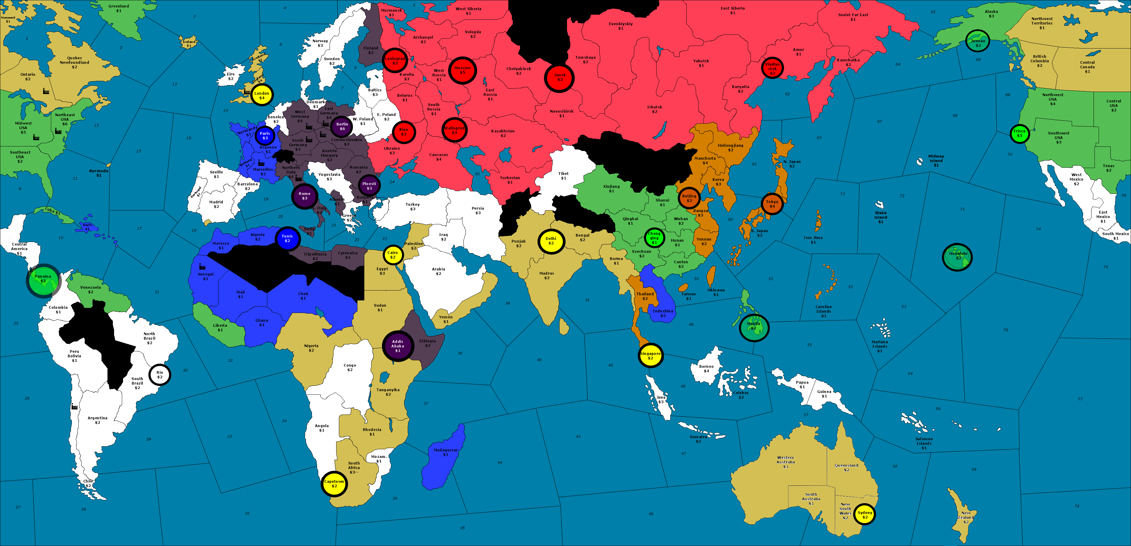
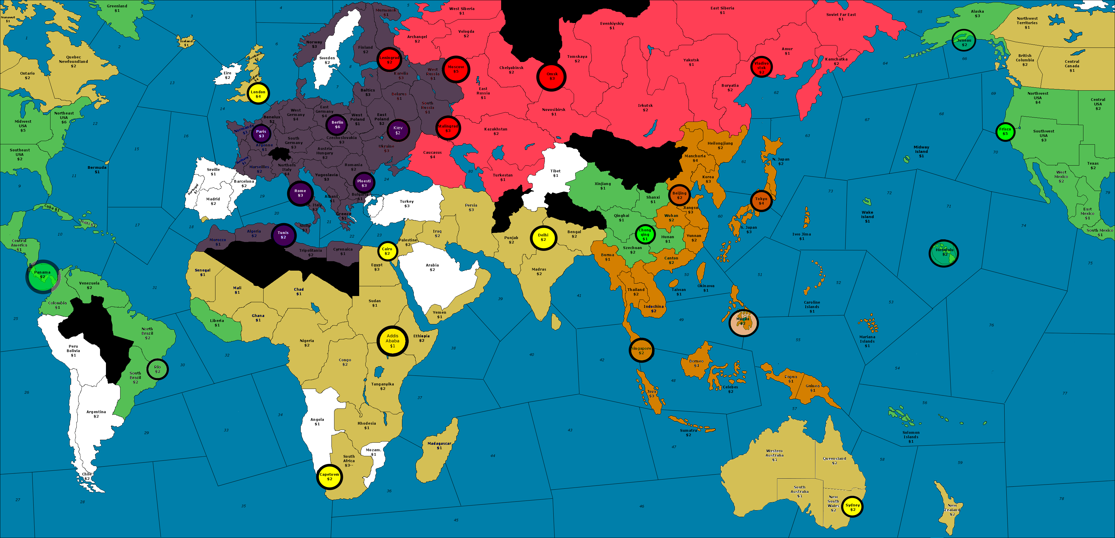
For a good example of this in the OOB games, just take a look at Australia. In Classic and up through AA50, this territory was a single space worth 2 ipcs. Although comparatively low value, and strategically out of the way, its value as a target territory for Japan was much greater than the same region in 1942.2, which has Australia divided into 2 spaces.
As a single territory in the earlier games, it had a potential value as a factory location (though almost no one would use it this way). At least it was an option for the cash grab. Sure, you had to go out of position for a round, but you picked up 2 ipcs in the process.
Global which took the Australia thing even further (and basically broke with any pretense that the IPC values of specific regions need to be consistent board to board) jumped the regional value of Australia to 7 ipcs!
Can you just imagine how important Australia would be in a game like 1942.2 if it was worth 7 ipcs in a single territory?
Granted in Global the income boost to Australia is undercut by the fact that Anzac is a separate nation, but can you imagine if it was under UK control, with the full weight of the British purse directed there? The territory would be absolutely critical.
It would make Australia a true Pacific prize that both Japan and America would definitely fight over. Even if you split that value over 2 territories (one worth 3 and the other worth 4) the strategic value of Australia would be major, and it could then serve as a springboard for all sorts of different Pac strategies.
But with two Australian territory tiles worth only 1 ipcs, is it any wonder that everyone just ignores these spaces in favor of India?
I’m not saying make Australia worth 7 ipcs, you don’t have to go that far, but I’m saying you could go higher than 2 ipcs haha.
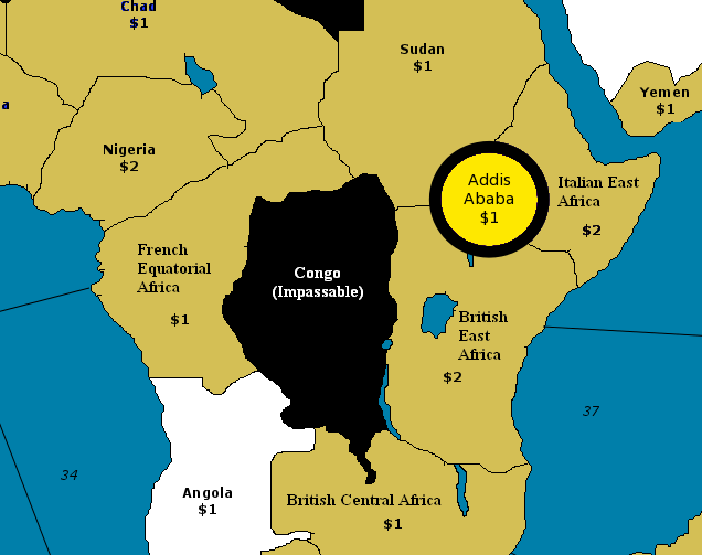
In global India is given a total regional value of 5 ipcs. That is less than the regional value of Australia in the same game. This really turns the normal situation on its head, when you compare Global to the earlier A&A boards, where India’s regional value always exceeded that of Australia.
My point here is pretty simple, that IPC values are fairly arbitrary, and as such, I think you should use them in whatever ways would seem to encourage the most fun from a gameplay perspective.
When in doubt, I say go little higher, by like +1 ipc. Instead of having a territory be worth 1 ipc, go up to 2 ipcs. Instead of 2 ipcs go up to 3 etc. If you don’t want a territory to just be a “speed bump on the way to somewhere more important” or just be “a distraction from the real goal” there are a lot of ways to accomplish this. First you can use starting factories as anchors for the fighting. 1942.2 does not handle this particularly well (in the case of India/Karelia) because while they do include the starting factories, the players who control them don’t really have the income necessary to defend them as choke points.
Its important to recall that every A&A game I’ve ever played, builds itself out around a Japanese expansion that goes well beyond anything that happened in the real war. So either you have to just suspend the disbelief, or I guess (if something more accurate was your aim) then you need to find other ways for Japan “to win” that don’t require a Godzilla globe trot.
Personally I don’t mind the Godzilla model, but the problem is that it always goes in the same direction (e.g Towards the Center, India, Suez Canal, Moscow.) What I would like to see is an attack route that brings Japan more into conflict with North America, rather than Russia. To achieve that I think you basically need two things…
1. more production value spread out across the Pacific (so Japan has some way to springboard over there, and pick up cash in the process, otherwise they’ll just ignore the area).
2. A sea zone design that allows Japan to shuck units in range of W. USA, along the southern route. Right now they only have the Northern Route, which although interesting is universally acknowledged to have a very low pay off, for the units required. At best its a stall tactic into Alaska, that never gets much farther than that, before turning around to dump units into the Soviet far east again.
Now imagine India as a single territory worth 5 or 6 ipcs, on par with France, rather than being all broken up into a bunch of useless 1 ipc territories. Now its a real anchor, a do-or-die type tile, where if Allies lose control of it, they’re basically losing the War. I think this could work, but only if Australia is of comparable importance. In Global, Anzac can’t really do anything, even if Allies are kicking ass, beyond just spamming aircraft. The region has IPCs, but they’re too split up to be of much use.
I like it when each nation has like 3 possible attack routes, where they could pick a focus, but only if they give ground somewhere else. I think the game works best when its possible to go maybe 2 out of 3 directions on the split purchase, but not all 3. And that if you ignore 2 directions to focus on just 1, then there should be definite cascading consequences along the other fronts, that way you can play the rush game where both sides have a chance to spin it their way. Just as an example, right now Japan has basically 1 route that can return victory (towards the center.) Even in Global with all the promise of the Pacific win, that still usually means making a B line towards India and the money islands. I think it would be cool if going towards Australia or North America could actually work sometimes instead of just being a “losing” strategy, that only beginners would adopt.
Taking it back down to a 1942.2 playscale, I’d say Australia as a single territory should have a minimum value of 3 ipcs (the replacement cost of a single infantry unit) and a starting factory to anchor it as a contested region. I think you could go up to 4 ipcs, and it’d still work fine.
As for trading territories back and forth, I kind of look at it like France. Say W. Europe is trading hands every round, I kind of interpret this as one side or the other “gaining the upper hand” in a region that’s being contested.
The early stuff is like Dunkirk, where UK is trying to hold onto a sliver of the coast. Then first time Allies take France in force with American boots on the ground, that is D-Day, But after this, if the Allies get ejected from France by the Germans a round or two later, I tend to look at that, not as “the Allies were driven back into the sea!” but rather, “ok now it’s the Battle of the Bulge, and Germany is kicking ass again, so France is up for grabs once more!” The ownership roundel at any given point, just indicates who is “winning” in that territory currently. Or at least that’s how I work it out in my imagination, when trying to come up with a narrative that makes sense. Otherwise the regions change hands too often to resemble anything like the campaigns of the actual war. Sure in the game it’s an all or nothing, winner takes the whole pie type scenario, but how you interpret what’s going on from a story telling dimension leaves you with a lot more flexibility.
:-D
Japanese-Soviet non-aggression pact changes the dynamic.
Japan can still aim at mainland VCs - India, China; but forget Moscow. You have to attack in the Pacific to take US attention away from Europe.
Without the pact, the games always default towards everyone piling units into Moscow, which can change hands 3 or 4 times a round!
All right, here’s another attempt at some of the same ideas, this time using the more realistic “Jason Clark” base tiles. My big innovation here is that all bold circles are victory cities, and vice versa – that way you can tell at a glance who’s winning and where your targets are, instead of having to squint to find the little red VC markers underneath your troops.
Note that all victory cities contain starting factories, which are not separately shown on the map. Some non-VC territories also have starting factories, which are shown on the 1939 map.
When conquering a territory with a factory, the factory is automatically destroyed, however, you are free to rebuild the factory on your next turn if you still control the city. Turn 1 Conquest, Turn 2 Build Factory, Turn 3 Recruit new units. That way there’s a bit of a delay in the city becoming 100% yours without the need for an extended ruleset about contested territories.
As always, let me know what you think!
Argo 1939 v3.png_thumb
The 1942 map.
Argo 1942 v3.png_thumb
Nice graphics, and the new VC circles are certainly easier to see than the traditional dots or squares. It looks a little odd to me, however, that Juno, Alaska, is a victory city whereas Washington, D.C. (unlike every other major-power capital) doesn’t even appear on the map.
Cool concept for the 39 map.
Just one thing to note, from Manchuria to Moscow there are only 4 spaces along the northern route.
A Japanese tank column blitzing from Manchuria to Novosibirsk has the direct line on the Russian capital in just 2 turns. One turn to land/build tanks in Manchuria, one turn to move them to Novosibirsk, and the Soviet purse is under threat.
This is not necessarily a bad thing, because it also means the Russian armor could do the same thing in reverse to screw Japan.
Here the thing that matters most is whether you give the Russians enough units to sustain a far eastern front. If the set up is designed for Soviet collapse in the east (e.g. the usual model of, “rush the infantry home! to defend Moscow”) then this sort of territory design would encourage the Japanese tank drive to Moscow. Basically Russia needs to have enough income/units in place to fight rather than fold, otherwise it would be pretty easy for Japan to overwhelm them along the northern route.
Wow! Your getting better at this. :-D This looks great. Also what CWO Marc said that there’s no Washington D.C. did you like forget about that?
There are several large black areas on the map. Am I correct that they represent areas which are impassable for either political reasons or for topographical reasons or for a combination of both? The area that mainly caught my attention was the one in the middle of South America. As near as I can figure it vaguely corresponds to a combination of the Amazon jungle (minus its eastern half) and the neutral country of Paraguay (plus part of Bolivia).
CWO_Marc, yes, the black areas are impassible, mostly for topographical and political reasons, but also partly to give some structure to the map – it would have been possible for the major powers to invade Mongolia, but with Mongolia closed, Asia has a much more strategically interesting shape. If you open up too many areas then Asia and Africa just become this formless enormous mass.
Frederick, thanks for the kind words. I can see that by popular demand, I’ll have to put Washington DC back on the map, which is fine – it can fit nicely between the Northeast USA and the Southeast USA. I left it out on purpose for game balance; the Germans shouldn’t really ever have a viable attack on Washington, and so making a Washington a victory city further adds to the already high count of starting Allied victory cities. Still, I guess people like to dream – I’ll put it back in.
Black_Elk, I didn’t originally intend to have only 4 spaces between Manchuria and Moscow, but now that I’m looking at it, I think it works for me. It almost mimics the path of the Trans-Siberian Railroad – you’ve got a direct beeline across Russia’s southeast, and then lots of space to go wandering in Russia’s northeast. I absolutely would want to give Russia enough starting troops in the east to hold out against a Japanese attack, and maybe forcing Russia to hold the ‘railroad’ will help deter KGF players from just immediately marching all their Siberian soldiers west. Also note that Russia can set up a roadblock at Omsk (a factory) and Novosibirsk – if Russia can hold those two territories (or hold Omsk and trade Novosibirisk) then the tanks aren’t going to get through to Moscow on any northern route. I am a little nervous about having Manchuria connect to SZ 60 – I would rather that tanks unloaded from Tokyo be one space away from Manchuria; I didn’t realize I’d left that connection open. What do you think about extending the Korean border west so that it cuts off Manchuria’s port access?
I remember making the case that having less territories in the soviet far east might actually be better for the Allies on balance than having more territories, I can’t recall the exact thread. But the idea was that more distance ends up hurting the Allies because they have no way to reinforce their line, and it makes the KJF positioning harder since you have a lot of empty worthless Russian spaces in the east. With a lot of low value territories Japan has it way easier to set up their their logistics train and Japan doesn’t need the income to be effective, whereas Russia has no incentive to stay and fight if you do it that way. I believe the original intension/argument that people made was “well, you need to stall the Japanese somehow, so lets just put more speed bumps in their way.” But I don’t think that really worked, as AA50 proved, to me at least. Better if the distance is short, so Russia can move ground units quickly.
I actually have the same view about the Pacific ocean. I prefer shorter distances, for rapid naval redirects. And instead of distance just give the two sides enough units to fight back and forth haha.
Yeah you could probably get away with having Manchuria be an inland tile, to avoid the dead drop from Tokyo.