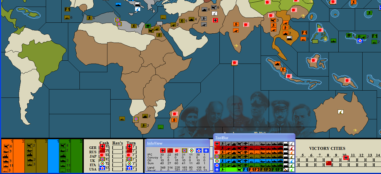
Modules for ABattlemap
-
Hey guys, just telling I’m keeping track of all these great ideas :-) But I’m having some busy weeks right now, so an updated map probably won’t see the light of day until next month.
As for the color of the Italians and Chinese: good point, some nice shade of blue might be good for the spaghetti eating people.
As for the names of the territories on the map, I’m still doubting, though it might be better for newer players.
As for fleet markers, seems like a nice improvement; there’s still some room on the lower left corner of the map to place the fleets there.
As for changing the territories to shades of green, this seems a bit impractical, and I’m not really a fan of it. But I do like the idea of cheering up the map placing some nice ships or aircrafts or tanks in the background, so if you’ve found some good pics d142, plz share them with us :wink:But one can always tailor a map to its own needs ofcourse :roll:
-
HolKann, sent you the file with Italy changed to Blues. It seems to be working for me for now.
As for fleet markers, you could use the unused Chinese ones and change them to Flags with numbers super-imposed on them. (Perhaps 2 per sea going nation?)
-
thats what i suggested 2 pages before. here is how it looks:
-
If you don’t use the big icons, they all fit and you don’t need fleet markers. :| Plus that has the potential of being very misleading, not being able to easily see what’s in a particular zone. The fleet markers should be very different looking from the units.
Why do the fleet markers need to be country specific? The F tokens get lost in the noise of the other units on the map. If you use the AAR model you could just have a bunch of generic marshalling tokens and marshalling “cards” or spaces on the map. Then at least it would be clearer that there were units missing and you would know to look at the marshalling area.
Oh, and the color scheme, especially the orange and blue is… um… how shall I put this…
garishinteresting! ;) -
i like it that way :D
but yeah you have a point about the markers getting lost. but
a) if you dont use the big icons, at least i myself cant see what unit is symbolized.
b) some seazones get very crowdedi like them because they allow u to move fleets with one click. thats why i made them and would like to have them.
this is minor finetunig and of course taste is diffrent :) good !
as for the colors: if you make them darker, you lack contrast, if you make them lighter u have some penetrative glow. both isnt an option for me :) i had the italians light grey, and liked that better too, i just made them blue too see if i like it :) i do, but grey was cooler
-
The units do fit, Tim. I believe Atari’s idea was a way to move fleets around the board without having to move 7 different stacks of units each time. (Fighters, Carriers, Battleships, Cruisers, Destroyers, Submarines, Transports and maybe even more if you have Infantry, Artillery, Armor and AA Guns as well!)
In that regard, I can understand it. Heck, we used to do that in Classic IRL with Face to Face games. We’d use an American Battleship with a Control Marker under it to represent a fleet (which was usually in one of the blow up boxes) or a Japanese Battleship or whatever nation it was.
This would just be the Battlemap Equivalent….though, it might be nice to have a purty picture instead of F1 or something. Wonder if it would be possible to get something like a BB/AC/Fig all on one token? I know they’re really small…actually, been wonderin if it would be possible to get some prettier icons all together…they’re bitmaps so they are limited, but common, there has to be a way!
-
I am a rookie AA50 player, and just recently found this forum, and consequently the ABattlemap for use in the forum based games. I am sure all of you who know what you are doing love it and do not need to change a thing, but I found a couple difficulties as a new player.
1. Cross referencing all the territory abbreviations and names is a real pain when trying to transcribe a move log. I doubt those of you who have it memorized care, but I absolutely love the modification that P@ther made to it. Kudos.2. Running at 1920x1200 resolution, my poor eyes cannot make out the subtle difference in the pieces, especially with the ships. Consequently, I modified the big pieces.bmp to use letter coded abrevs for all ships but the Carrier and Batleship (easy enough to tell them apart). For the life of me I cannot figure out how CA comes from Cruiser, or DD comes from destroyer, but I picked up on it and used those codes, along with S for sub and T for Transport.
If you a poor little rookie like me and are having problems with the naval pieces like I did, I am attaching the modified BigPieces.bmp file for anybody that wants it. Just drop it into your A50 folder after renaming the extension back to .bmp. The majority of you can ignore it, but in case you have bad eyes like I do, feel free to use it.
-
I’m redoing the color scheme, and after a lot of trying, I’ve got the scheme as attached to the post. What do you guys think of it? I’m not finished yet with the map, so I’m not updating yet.
Also, if someone could provide me with a “layered” image file with in one layer the AA50 map, and in an other layer the territory names, I would be very much obliged :)
-
Holkann, I’m sorry, but my red-green color-blind eyes just can’t distinguish between the 2 greens - UK and US.
I’m using the updated module, but I’m still using the older pieces, even though I still have a slight problem distinguishing between the yellow Japs and the yellow-green Americans. At least their ships look different. That helps me a lot.
-
I’m redoing the color scheme, and after a lot of trying, I’ve got the scheme as attached to the post. What do you guys think of it? I’m not finished yet with the map, so I’m not updating yet.
Also, if someone could provide me with a “layered” image file with in one layer the AA50 map, and in an other layer the territory names, I would be very much obliged :)
Here it is:
http://www.mediafire.com/download.php?ghjynmootyyUse the file with paint.net. See www.getpaint.net
In case you don’t know it.Hth :-)
-
I really see no need for all these constant changes that lead to compatibility issues as far as changing territories around and such on the map.
I agree with Tim as far as adding fleet cards and such. It is too easy to overlook what is where. It is not like we are trying to cram physical playing pieces into a territory or move the same about the map and having to worry about pieces falling off of a stack of chips.
-
I really see no need for all these constant changes that lead to compatibility issues as far as changing territories around and such on the map.
I agree: it’s not a good idea constantly changing territory shapes… But one has to admit the map isn’t optimal: it is irritating to have so little space in Lib, Alg and Egy whilst wasting a whole Sahara on useless terrain, and also the way the Pacific was organised was strange and inefficiënt. So imho it is recommended to fix these “errors” even though it compromises compatibility. The best way to accomplish this is simply by fixing all the things that will reduce compatibility in one patch, and then continuing to add markers or whatever needed would have no influence on compatibility, thus making it no problem fixing small issues one at a time.
So I think I made a small mistake uploading an uncompatible version without making sure every compatibility issue would be solved this way. As I said: I’m probably gonna adjust the Sahara region, add some places where fleets with fleet markers can be put, add territory names etc. But I’ll make sure this will be the last update that adresses things influencing compatibility. Also, after this update, I think the modules are about as good as they can get, and it’ll probably be the last update I make. Unless ofcourse someone likes to do a photoshop job to make the .bmp files itself less dull :roll:
Don’t worry, no one can keep improving the modules forever, so give it a little more time and the modules will be finished, with a final version posted in this thread. After that, you’ll have hours of joy and happyness with an optimal set of modules which won’t be altered for decennia :wink:
I agree with Tim as far as adding fleet cards and such. It is too easy to overlook what is where. It is not like we are trying to cram physical playing pieces into a territory or move the same about the map and having to worry about pieces falling off of a stack of chips.
I agree again, but adding fleet cards gives people the choice to use them; those who like them use them, those who don’t don’t.
Holkann, I’m sorry, but my red-green color-blind eyes just can’t distinguish between the 2 greens - UK and US.
I’m using the updated module, but I’m still using the older pieces, even though I still have a slight problem distinguishing between the yellow Japs and the yellow-green Americans. At least their ships look different. That helps me a lot.
Since I don’t have a clue on what red-green color-blindness is, I won’t be able to fix this. What I’m trying to do is making these modules as enjoyable as possible for people with normal sight playing on normal resolutions, since I simply can’t do it for other people. However, I’m willing to help you make your own adjusted version of the map and pieces to fit your own needs. It’s very easy to do whilst only using MS Paint (standard on every Windows machine). So if you wish to make your own pieces but you don’t know exactly how, PM me :)
-
@P@nther:
I’m redoing the color scheme, and after a lot of trying, I’ve got the scheme as attached to the post. What do you guys think of it? I’m not finished yet with the map, so I’m not updating yet.
Also, if someone could provide me with a “layered” image file with in one layer the AA50 map, and in an other layer the territory names, I would be very much obliged :)
Here it is:
http://www.mediafire.com/download.php?ghjynmootyyUse the file with paint.net. See www.getpaint.net
In case you don’t know it.Hth :-)
Tnx :)
-
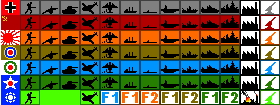
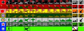
big pieces, with a new color scheme
-
how are the fleet marker’s used ?
-
how are the fleet marker’s used ?
A fleet marker represents a fleet in a seazone. So you do not have to move lots of ships from one sz to the other but only the fleet marker.
There will be a place on the board (for example a neutral territory or special fields) where the “real fleet” will be stored.I learnt from this thread
http://www.harrisgamedesign.com/bb2/viewtopic.php?t=1702&sid=9283f45b3a668d14b6f3077ac48c4027
that in former versions of AA there were so-called “Marshaling Circles and Cards” which had the function above-mentioned.Of course this is not limited to fleets but can be used for all groups of units.
-
how are the fleet marker’s used ?
they are used just like the marshaling circles from AA Revised. You put the actual fleet/army in whatever unused space you want (neutral territory/ AA logo on bottom-left).
-
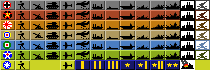
Hey all, uploaded a final version of ABattleMap (final in the sense of: no more compability issues after this one).
Things changed:
- smaller Sahara ;)
- fleet markers
- fleet marker space in the lower left corner of the screen
- recoloring of pieces and map so the Italians and Chinese are a bit better to distinguish.
- some minor territory redraws
- added territory namings
It will be the last version of the modules which might raise compatibility problems, maybe some day I’ll add some extra figures in the background, but that won’t affect compatibility.
Have fun :-)
-
Great work, thank you, HolKann.
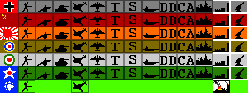
I just want to offer my mod of BigPieces.bmp
The bomber is slightly different (the way it “throws” bombs), I “enlarged” and partly “redesigned” the ships a little bit.
Using the same color scheme I saved them as 8bpp-bmp instead of 24bpp. So the file size is even smaller.
Personally, I cannot view a difference between 8bpp and 24bpp on my screen.Download from
http://www.mediafire.com/download.php?wymm2zmj3zn
if you like (3.34 KB - 7z-format).:-)
-
No offense, but I like my Italian colors better, possibly because I am used to that shade of blue. /shrug.
Anyway, the white lettering kind of clashes, don’t you think? Maybe it’s just my girlishness but wouldn’t it be better if the Sea Zones were numbered with a lighter or darker shade of blue (something that contrasts, but does not clash) and the territories with lighter/darker shades of themselves?
Maybe the Italian color for Sea Zone numbers, Japanese colors for Germany, German Colors for Japan, etc?


Suggested Topics

