• Thank-you IL. As far as we can see this is identical to the OOB map and the UK A&A community are getting three printed.

    Cheers
    PP

  • '18 '17 '16

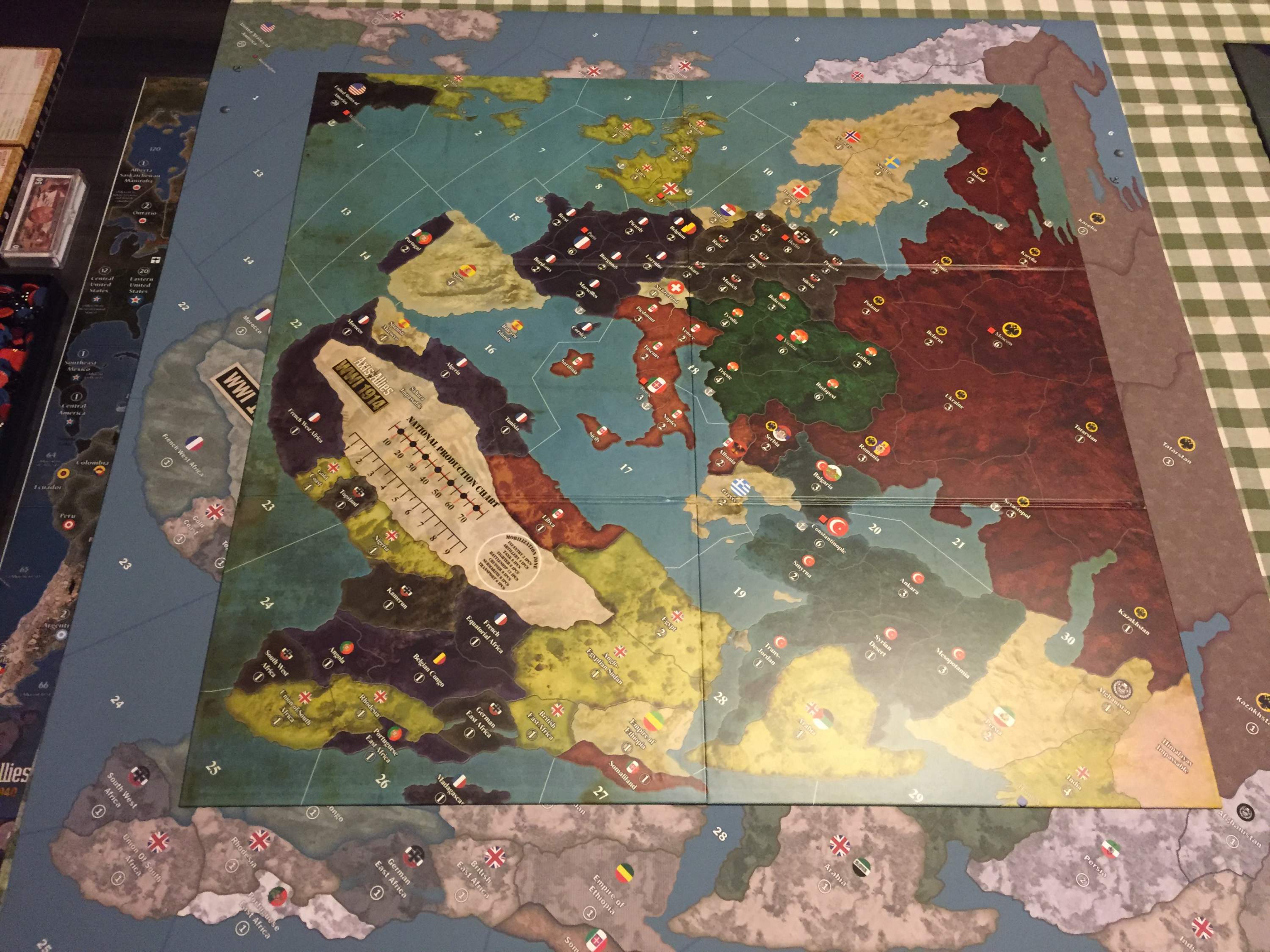
    You did a great job with this map Imperious Leader. I like the fact that the changes were subtle because it was already a nice piece of work to begin with. The first game I played I forgot all about the mines that were connected to the harbours but this map would never let me forget that. I also had to keep looking in the rule book for order of play and starting incomes because I hate using an income tracker and prefer to count up my income when it’s time to collect, so doing away with the tracker and adding what you did in the Sahara is perfect. I would be interested in a copy of this but I have a couple of questions though. Can this be printed out to any size or will it ruin the quality if I print it too large? The OOB map is just over 32" by 32", I would like mine to be 42" by 42". Also, is there a way to edit it to increase the size of the emblems on the capital territories? This is important because the rules specify that only a minor capital can be mobilized whereas a minor colony does not. The way these are differentiated on the OOB map is they have larger emblems on them like the Major capitals do. For instance, in Africa only the Empire of Ethiopia would mobilize troops if you entered it. On your map all of the territories have the same size of emblem on them.

    I made a list of the territories that should have the larger emblem if you should be inclined to change them yourself;

    United States
    London
    Portugal
    Spain
    Paris
    Rome
    Holland
    Belgium
    Berlin
    Switzerland
    Norway
    Sweden
    Denmark
    Vienna
    Moscow
    Albania
    Serbia
    Romania
    Bulgaria
    Constantinople
    Greece
    Arabia
    Persia
    Afghanistan
    Ethiopia

    I don’t know how to make these changes myself but if you didn’t want to maybe I could find someone else who has the time and the interest. There’s a steak dinner and a bottle of whiskey in it for you if you make the changes but you have to come to northern British Columbia to collect them.  :-)


  • The “emblems” are .75, so if they are captured, the token of the capturing player exactly covers it., I think they look large IMO but they do serve a purpose.

    Thanks for your kind remarks.

  • '18 '17 '16

    Ok I can just keep a list of the capital territories until I have them memorized. Most of them are obvious anyway so it shouldn’t take that long to memorize.
    How about enlarging it, can I do that without ruining the quality?

    BTW I can’t wait until your game comes out it looks awesome. I spent an hour last night reading the thread about it and I hope I will be able to get one of the limited quantities. I wouldn’t bother with the A&A 1914 game but I already have invested money in purchasing it ( along with the extra pieces that should’ve been there in the first place). I think it has some good qualities and I think that I can fix it to the point where it is balanced. A lot of good suggestions have already been put forth on the 1914 forums so I’m hoping to build on them.


  • IL, I must say I am very thankful for all your effort on the maps you put out. I think I have printed just about every board now from (Global, 1942 2nd, 1942 revised, 1942 50th and now 1914).  It definitely creates new excitement in game play.  I just re-ordered the 1914 as my first print was only 36x36, which is still larger than the original however, Europe is still tight.  I think the print shop will be increasing the size to 48x50.  I think this should open up Europe a bit.  Has anyone else printed this out 48x48 or larger?

    Anyway, even at 36x36 it is nice not having the seams.

    Thanks again for your work on these.


  • Thanks, and i would reprint as it is which from memory is 2X original or possibly 48" square

  • '18 '17 '16

    I brought home my 1914 map from the printer today. I went with 42 inch vinyl copy. The colors didn’t come out as dark as a paper map but I like the soft feel to the surface. Here is a pic of the OOB map on top of the vinyl map to get an idea of the size difference. I don’t think you would need a larger size than 42 inch because there seems to be lots of room to fit pieces. Even Europe has enough room to hold everyone. Thank you IL for the map file. You rock!

    IMG_0179 1914 oob & vinyl.jpg

  • '18 '17 '16

    This pic of the opening setup shows how much room you have to contest territories. I should even be able to fit a few zeppelins in there.  :wink:

    IMG_0181 europe space.jpg

  • '18 '17 '16

    One last shot. The role of the neutrals is graciously being played by an old set of WW11 Russian infantry and artillery that I painted black.

    IMG_0183horizon1914.jpg

Suggested Topics

  • 3
  • 11
  • 1
  • 8
  • 8
  • 12
  • 3
  • 25
Axis & Allies Boardgaming Custom Painted Miniatures

27

Online

17.0k

Users

39.3k

Topics

1.7m

Posts