


Indeed. The Central Powers and winning in the game, Russia already capitulated (revolution).
Game Board Frustration
-
Also, the neutrals you mentioned what likely be involved so it was necessary to divide them up into smaller territories. I am planning on making a blown up version of the western front to alleviate the congestion.
-
Marshaling cards from A&A revised come in pretty handy in this game.
-
@Uncrustable:
Marshaling cards from A&A revised come in pretty handy in this game.
AGREED.
-
I don’t understand why the cut in the boards runs from north west to south east.
It should instead run through North Africa, the Med, and Ukraine.
The Belgian roundel never matches up right…… -
I don’t understand why the cut in the boards runs from north west to south east.
It should instead run through North Africa, the Med, and Ukraine.
The Belgian roundel never matches up right……Agreed, I don’t think the board should run right through the most important and crowded front of the war.
-
You nailed it. Belgium tends to be a primary staging point, yet sits atop a fissure. Le sigh.
I don’t understand why the cut in the boards runs from north west to south east.
It should instead run through North Africa, the Med, and Ukraine.
The Belgian roundel never matches up right…… -
Where the maps meet has always annoyed me about most A&A games.
This one is a good example, Oztea.
It just seems scruffy. -
If scandinavia was pressed smaller like the did with Africa it would have been possible to make central Europe larger.
I also agree about needless Russian tts in the east. -
If scandinavia was pressed smaller like the did with Africa it would have been possible to make central Europe larger.
I also agree about needless Russian tts in the east.Good point. As far as I’m concerned they also could have left out Africa altogether to allow more space for the areas where the war was really lost and won.
-
Only include Africa if you are going to give the CPs(Germany) a fighting chance of retaining their possessions.
Flashman’s proposal for one Inf a turn for Germany seems reasonable to me. -
Actually my proposal is for Askaris for any colonial power, maximum 2 per turn in different original colonies.
Each starting inf in Africa would get a couple to begin with as well, just to get things going.
-
If scandinavia was pressed smaller like the did with Africa it would have been possible to make central Europe larger.
I also agree about needless Russian tts in the east.I agree. If they scaled down the size of those and Spain, maybe even the size of SZ 17 and some of the various Russian territories, then there could be a little more breathing room in Europe.
-
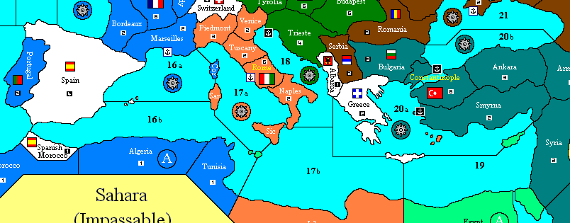
I’ve suggested redividing the Med as follows:
-
I’ve suggested redividing the Med as follows:
I like that you have SZ20 divided which would allow the Ottomans to control sea movement through the straight.I’ve wondered why the game has Constantinople spanning across a single SZ which allows enemy ships to travel through. Hopefully it was a balance issue and not a mistake.
However, I like that the original map has Rome only adjacent to SZ17. It may be too easy for AH to take it on your map. Unless the allies take out their navy of course.
-
Notice I also gave Rome 6 IPCs. If Austria starts building transports Italy should have the sense to leave a strong garrison in Rome, or get its allies to join it in obliterating the Austrian fleet.
I actually think Rome is more defensible anyway with this arrangement, as Austria cannot grab Naples by land and deprive Italy of another 2 IPCs.
The other main objective is that the SZs bordering Africa have no mines, which should make naval combat more lively; the CP fleets can link up, or invade north Africa.
Albania is less open as a gateway into the Balkans for the Allies; Greece is more attractive now as it doesn’t border Constantinople.
-
The other main objective is that the SZs bordering Africa have no mines, which should make naval combat more lively; the CP fleets can link up, or invade north Africa.
That definitely think that could change things up a lot. Those mines in SZ17 and the large allied fleets make any early AH naval plans difficult.
Suggested Topics

