


@Pvt_Griff Thank you! Let me see when your done! Now just cointemplating buying a global game and getting BBR or something going. Daunting task for sure.
Custom Map
-
Gorgeous bgugs!!! Keep it up.
-
Mr. Tricorder, you said you have used inkscape before. When working on this map it began placing white squares anywhere I attempted to draw. It wasn’t actually placing the blocks there just displaying them. What I mean is it would still draw the color I wanted where I wanted but would display a big white box over where I was attempting to draw until I zoomed either in or out. Because of this I tried to save my work and reopen it and see if that would work. Now when I reopen the file there is nothing there, not the original map or the map plus my edits. Any idea what may have happened?
-
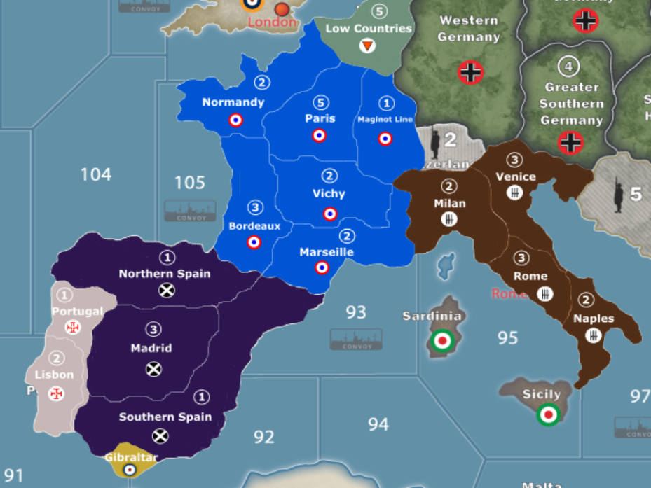
Here’s a look at how Western Europe is coming along
-
bgugs, that looks awesome! Great job on this. :-)
-
Thanks. I am trying for a more complex map with likely more complex house rules applied to a variant game. It likely will not be welcomed by many gaming groups but a game with more complexity and more variability fits my groups desire so that is the way I am going with my project.
-
Thanks. I am trying for a more complex map with likely more complex house rules applied to a variant game. It likely will not be welcomed by many gaming groups but a game with more complexity and more variability fits my groups desire so that is the way I am going with my project.
I here you. The more variants, the better for the community. :-)
-
You should consider adding Reims/Dunkirk to your map, bordering Low Countries (Belgium). A 1 shot deal into Paris is kinda defeating the purpose of your map
-
That’s still something I am torn on. I am worried about spacing and not making Europe overly crowded in certain territories, and I was kind of looking at making Germany have access to almost all of France once they conquer Belgium (much like they did in real life). I am still working on it and that is still something I am considering though
-
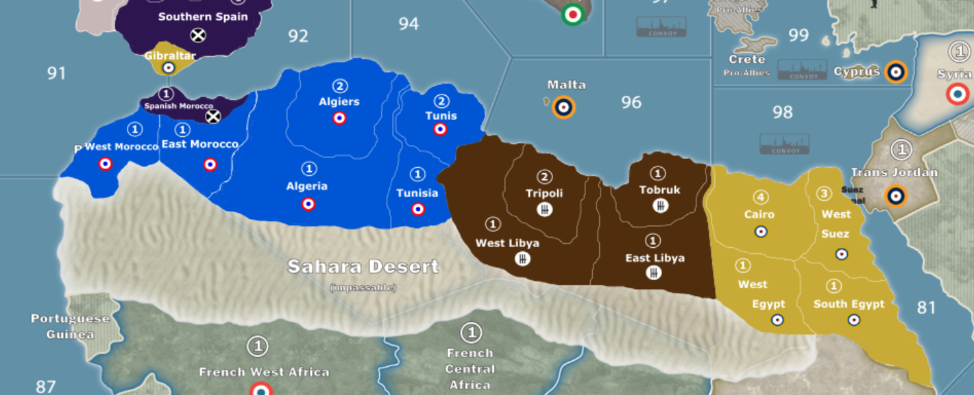
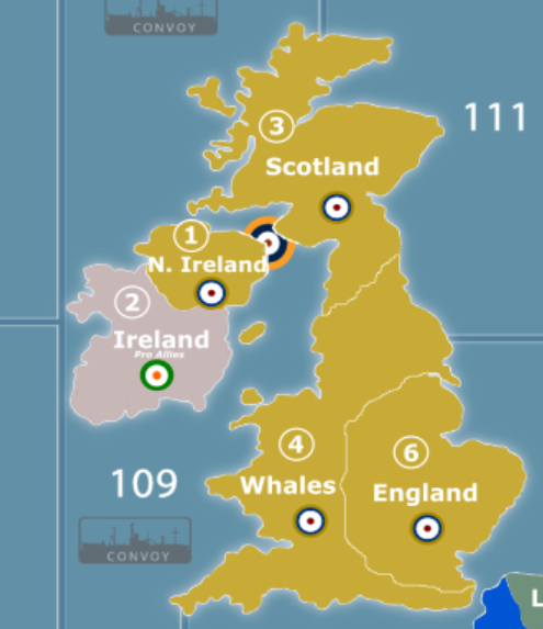
North Africa and Great Britain
-
North Africa and Great Britain
Nice maps. The Great Britain one, incidentally, should say Wales, not Whales.
-
That’s embarrassing, didn’t even notice that. Thank you!
-
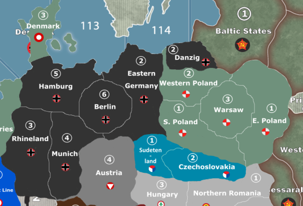
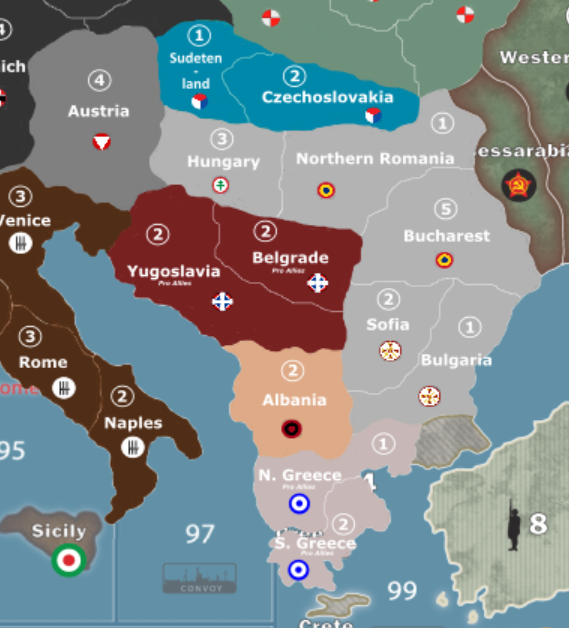
Been a while since I shared on here due to being busy and not having a lot to share, but here is Germany/Poland/Southern Europe
-
Mr. Tricorder, you said you have used inkscape before. When working on this map it began placing white squares anywhere I attempted to draw. It wasn’t actually placing the blocks there just displaying them. What I mean is it would still draw the color I wanted where I wanted but would display a big white box over where I was attempting to draw until I zoomed either in or out. Because of this I tried to save my work and reopen it and see if that would work. Now when I reopen the file there is nothing there, not the original map or the map plus my edits. Any idea what may have happened?
I’m very sorry. I haven’t visited this thread in a while and didn’t see your question until just now. I haven’t used inkscape in years though, so I don’t know what’s going on there. I have an Adobe Creative Cloud subscription, so I do all my vector-based artwork in Illustrator now. If you’re still having this problem, I would recommend checking out the inkscape support forums.
-
Not a problem. I was speaking to panther about the problem when it suddenly fixed itself. So now everything is working great
-
This project is not forgotten or given up on. I have made some great progress in the pacific so far. However, due to repeated issues with inkscape and the fact that I have basically had to redo all my work a few times, I am going to look to switch over to adobe programs. Once I have more figured out I will share the progress I have made
-
you can also look at Affinity products.
They have a PS and Illustrator replacement.
Cheaper and no subscriptions.
Caveat is they are newish and are not as chrome laden as adobe stuff.
But for this job, they would work fine. -
This map looks really great! Love to see this progressing
-
Robert have you worked with Affinity’s designer program? It seems nice, but since it is new I just want to make sure I am not spending $50 on something that will be riddled with bugs
-
I’ve dabbled in Affinity designer and photo. I use Adobe Illustrator now for work but am slowly learning designer as it probably will replace AI in the future. I won’t pay Adobes software ransom demands.
Designer has been going since 2014 so it does have growing pains trying to get on par with Illustrator. ( I won’t say it is riddled with bugs, just not as feature rich as AI )
Photo on the other hand is a viable PS replacement. (more money in creating a PS app than a vector app)
That said, it should work fine for most if not all your needs.Really though, there is no other alternative AI when doing large files/maps.
If you are not in a hurry, check the app store on major holidays as these do go on sale. I think I got mine on the July 4th or Black Friday sale.
Hope this helps.
Robert -
i use too Illustrator to make a custom map and by my own opinion, it’s the best software to create large map. After it’s right, it’s not the cheapest software…
Siredblood is creating his map wth Photoshop, i don’t know how he can do it with a such great result
Suggested Topics

