


@Krieghund Thanks
Supreme map 1942 ed 2
-
Will wait for the two last one, check them, and see which one i will print.
It would be sufficient, if you checked just one of the files! The files are more or less identical. If the 3-borderstyle map with IPC and Mz is correct, than the other files would be correct, too. The remaining two versions (without Mob zone, without IPC-Chart) I’m going to release as soon as no failures occure in the check of the already uploaded files.
This procedure is just due to a lot of work lurking if only one mistake is revealed: if one file is incorrect, I will have to correct all four files, make four new pdf’s und will have to upload four more files. Thats two hours of work.
-
Will try to check the map tomorrow.
-
Ok Dedo, i spent some time checking the 1942 2ed and 1941 maps. I will reply in the right section for 1941 ed.
So, what i noticed concerning the 1942 2ed map :- The most schocking is the german insigna : there is some red missing up and down which gives them a weird/unifinished look. (and under the title of the game too)
- East Mexico, not East Mexiko, and Mexico, not Mexiko
- “Panama Canal” and “Suez Canal” are missing
- On the original map, it is written “Anglo Egyptan Sudan” not “Anglo Egypt Sudan”
- The slashes (ex : Spain/portugal), i think they are too thin.
- The drawing on Sea zone 55 & 58 has a problem of transparency if you look closely (the other drawings do not have this problem)
- Sea zone 52 : this is written Wake instead of Wake Island
- On the mobiization zone, “UNIT STATS” is missing if compared with the original. Stas are ok, even not given in the same order (i personnally prefer yours)
- The starting IPC are 31 for UK (instead of 30) and 41 for Germany (instead of 40) . RThere may be an errat, i did not check.
Hope that helps
Phil
I won’t have accesss to the internet until friday.
-
The most schocking is the german insigna : there is some red missing up and down which gives them a weird/unifinished look. (and under the title of the game too)
No change, it must be an individual screen solution error, can’t see any differences.
East Mexico, not East Mexiko, and Mexico, not Mexiko
Fixed.
“Panama Canal” and “Suez Canal” are missing
Fixed.
On the original map, it is written “Anglo Egyptan Sudan” not "Anglo Egypt Sudan
Fixed.
The slashes (ex : Spain/portugal), i think they are too thin
No more slashes.
The drawing on Sea zone 55 & 58 has a problem of transparency if you look closely (the other drawings do not have this problem
Fixed.
Sea zone 52 : this is written Wake instead of Wake Island
Fixed.
On the mobiization zone, “UNIT STATS” is missing if compared with the original. Stas are ok, even not given in the same order (i personnally prefer yours)
No change, I omitted “unit stats” voluntarily, there is no relevant information.
The starting IPC are 31 for UK (instead of 30) and 41 for Germany (instead of 40) . RThere may be an errat, i did not check
No change, 31 and 41 are the correct IPC values, already displayed on the map.
Hope that helps
Yes, it did.
-
Final version 1 of 5
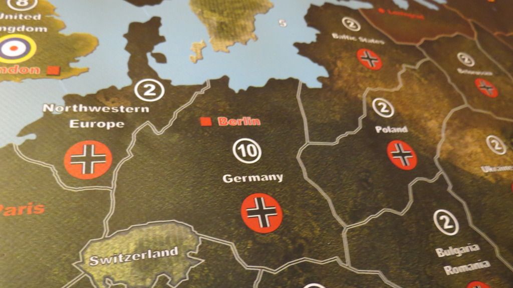
Map: 1625x863mm, double border design, with Mobilization Zone and with National Production Chart- So far no additional feedback received concerning the latest version of the map
- Checked again all borders, seazones and territories
- corrected one border (missing border between Southern Europe and Italy)
- 3 graphical errors corrected
Here is the link to the hopefully last version of the map:
http://www.mediafire.com/view/7r3hayfq4hxvb6u/1942_ed2_double_border_-MZ-_-NPC-.pdf -
Final version 2 of 5
Map: 1625x863mm, double border design, no Mobilization Zone and no National Production Chart
- So far no additional feedback received concerning the latest version of the map
- Checked again all borders, seazones and territories
- corrected one border (missing border between Southern Europe and Italy)
- 3 graphical errors corrected
- 1 additional transparent picture (B-17 squadron)
Here is the link to the hopefully last version of this map:
http://www.mediafire.com/view/9sez5n2h5xd7rsk/1942_ed2_double_border_noMZ_noNPC.pdf -
Final version 3 of 5
Map: 1625x863mm, triple border design, no Mobilization Zone and no National Production Chart
- So far no additional feedback received concerning the latest version of the map
- Checked again all borders, seazones and territories
- corrected one border (missing border between Southern Europe and Italy)
- 3 graphical errors corrected
- 1 additional transparent picture (B-17 squadron)
Here is the link to the hopefully last version of this map:
http://www.mediafire.com/view/cum733o6y8wqrrj/1942_ed2_triple_border_noMZ_noNPC.pdf -
Final version 4 of 5
Map: 1625x863mm, triple border design, with Mobilization Zone and with National Production Chart
- So far no additional feedback received concerning the latest version of the map
- Checked again all borders, seazones and territories
- corrected one border (missing border between Southern Europe and Italy)
- 3 graphical errors corrected
Here is the link to the hopefully last version of this map:
http://www.mediafire.com/view/8z2ncptrkbn3xtl/1942_ed2_triple_border_-MZ-_-NPC-.pdf -
As i said for the 1941 map, thanks to you. It only took me one or two hours to check all the things, nothing compared to your work. :wink:
Hope this is the final version !
For the german insigna, i will upload a snapshot. I won’t be out without internet like the last three weeks, so i will be able to reply faster :-) -
Ok, here is the explanation of the “weird” german insigna : we checked the maps on my girlfriend’s computer (os Linux, software to read PDF Evince)
Here is what we saw at 100% zoom :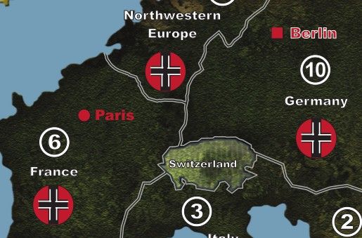
Today i opened the file with my computer (OS Windows 7, software to read PDF Adobe Reader
Here is what we saw at 100% zoom :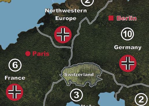
Can’t explain why. I hope the printing will show the good one !
-
Well, the explanation could be: do not trust a computer of a girlfriend…
Joking aside, I don’t know the reason, why the map is displayed in a different manner: may be, it depends on an appropriate PDF-Reader (version?). However, I’m totally convinced that the map will work as I already have got a printed version, where the insignia are depicted correctly. Apart from that: the insignia is one “piece”, that is, it is not consisting of a set of elements (e.g., black lines, white lines, red circle). -
I suggest you test print a small section of the map on your printer. Most likely also the adobe reader is not the latest version, and third that computer may have to need the video driver updated.
-
There is one thing i hadn’t noticed but the MZ chart is near Africa and that gives a overcharged mass, graphically speaking, of the map. I think it would really be improved if it was placed in sea zones 41, 42 and 43. That would be more balanced, and it would look like the original map. You’d be my hero if you could make the changes on the different versions. :mrgreen:
-
A little up, just in case Dedo is around…. :-)
-
Final version 5 of 5
Due to special wishes from a very special community…
one additional, final map:- double border design
- Mob Zone in the South Pacific
- B-17 Squadron picture in the South Atlantic
-
A thousand thanks to you Dedo :-)
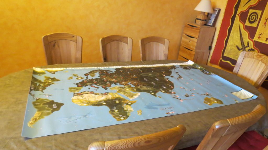
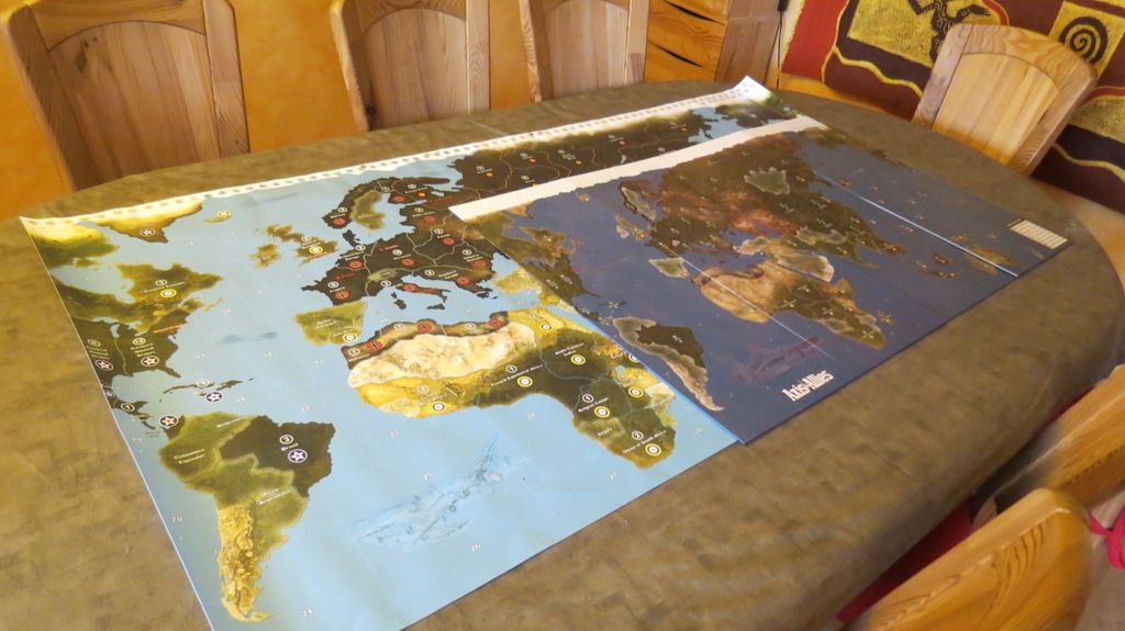
I will receive it on wednesday and post some photos. -
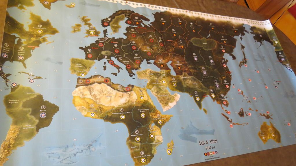
Here is the final result : perfect :lol:
-
Happy for you! I must admit, nice result! First appearance of the B-17 formation, have some fun and nice games!
-
Happy for you! I must admit, nice result! First appearance of the B-17 formation, have some fun and nice games!
Thanks again for everything. Your work is excellent. Played twice on the giant map, a pleasure, like a dream come true :lol:
-
Amazing job guys, love how a colaberation of skills can produse great work!
I will be printing this for sure, perhaps next winter after my bunker renovations, I love how you corrected many of the graphic flaws that I had issues with.
Cheers.
Suggested Topics

