


@Lompestein Awesome work! Big thanks for including the .xcf’s and brushes as well, that should help others get a leg-up on their own projects.
Tjoek's 1940 Global Map file and setup charts (Updated May 30th 2018)
-
After some hard work and playing our second game of Global 1940, I’ve finished Europe and have reworked Africa for 80% now. The project of reworking the great map from Ambilzi and Young Grasshopper is taking far more time then expected, but the results are very satisfying. So let me share with you the biggest challenge in Europe: Switzerland. It’s in the middle of a crease and split across two boards. And with the size of the country there’s is not much original artwork to play around with. Please let me know what you think of the results
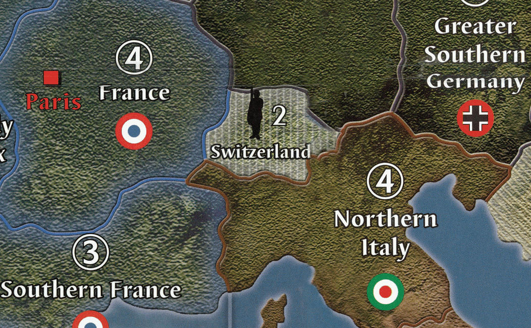
Please note that the coast of Northern Italy as well as the crease (and text distortion) on both France and Greater Southern Germany have been fixed as well. This part of the board has given me some hard time :-)
-
Really great work so far! I also plan to print myself a map and with your project going on at the moment, I will pretty sure wait for that to be finished :-)
I know, you already plan 2 versions with different layers, like the standing armies on neutrals.
What features of the Ambilzi/YG map will you keep on your map? Or will you go with the plain original map? Will there maybe be more than 2 Layer Versions?Personally, I would especialy find the Naval/Air Bases very useful and the extended income tracker.
-
I know, you already plan 2 versions with different layers, like the standing armies on neutrals.
What features of the Ambilzi/YG map will you keep on your map? Or will you go with the plain original map? Will there maybe be more than 2 Layer Versions?I’m working with the plain original map, because I like a clean map as a map only and have all the other stuff like battle boards, cost charts, income tracker apart from the board.
But with this ‘clean’ map as a basis, it shouldn’t be a big challenge to blend back in the naval and air bases or any of the other features from the full Ambilzi/YG map.When I’m done working on this map, I’m more then happy to create you a blend. If you are kind enough to share me some pictures of your printed map / table :-)
-
When I’m done working on this map, I’m more then happy to create you a blend. If you are kind enough to share me some pictures of your printed map / table :-)
That sounds like a fair deal! :-D
-
A quick update. Africa and the Middle East have been fixed. Especially the neutrals in the Middle East proved to be challenging. Now rolling into the USSR.
-
Your right about the font, i now remember that the Franklin font looked better so i went with that.
-
@Imperious:
Your right about the font, i now remember that the Franklin font looked better so i went with that.
That’s not a problem. Do you happen to know what the original font was called?
-
I stopped looking because that Franklin font is better and sorta similar to OOB
-
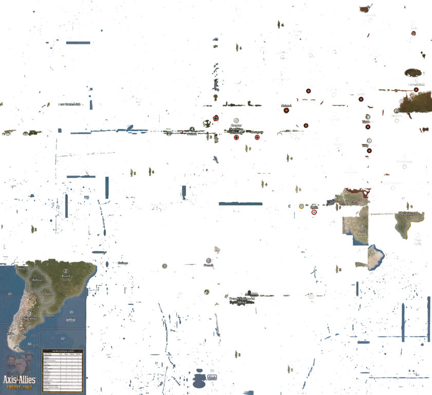
Yes!! Finally managed to finish the European Theater of the map. Just for you all to get a feeling of how big this rework is to fix all the dust particles, scratches, fold creases and scan line - I’ve added a picture that shows all the changes to the original map.
The results are very satisfying and I cannot wait to finish the Pacific theather and get this clean map printed.
-
WOW, you can really see where the boards were stitched together.
-
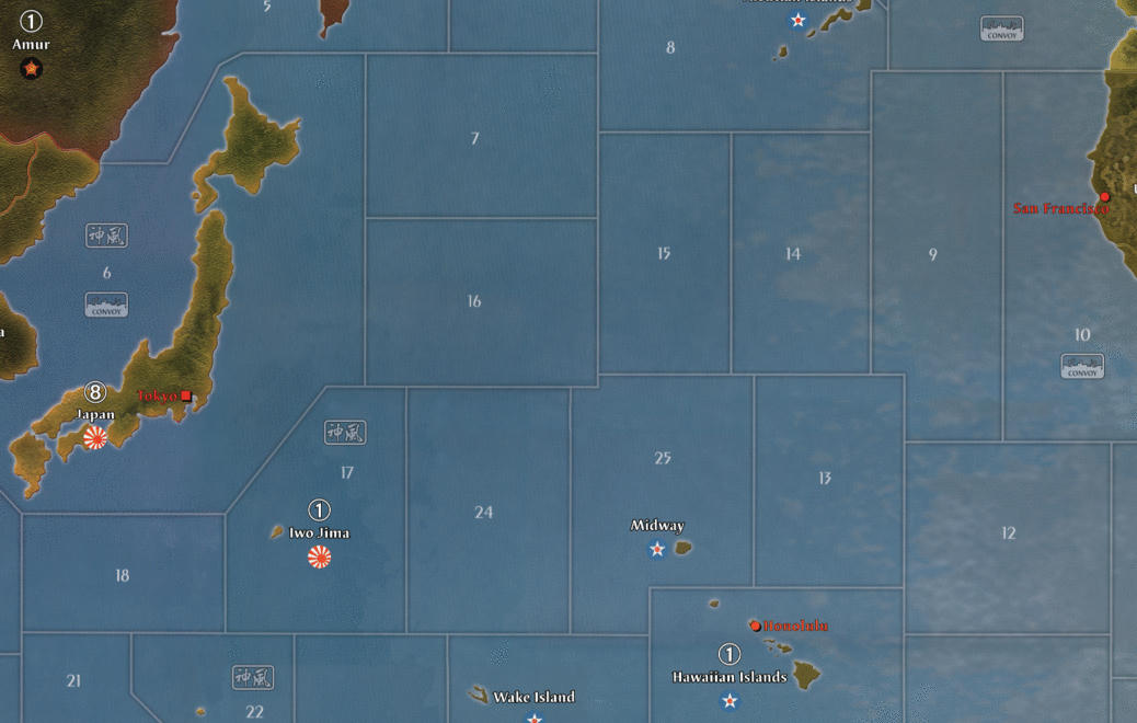
Quick update to you all. 6 months have passed, but not without progress on the map! I’ve fixed all lands / islands except for America on the pacific board. This work took forever to complete, but I’ve learned a lot on this journey and will retouch some of the things on the european side as well. Especially better contrast on country names.
I’m currently battleing my way through the pacific to minimize the visible lines of where the scans have been stitched together. See this image as a reference of what I’m talking about.
Please note I’ve also:
-
aligned sea borders better and in straight angles
-
moved Honolulu to where it should be
-
flipped Iwo Jima to it’s right orientation (inspired by Intrepred’s great work)
-
it’s still WIP as you can see from the dark line running north of Wake Island and through Hawaii
Let me know what you think!
-
-
Just a quick update to let you all know this project is not dead. After some months out of the running I’m regaining energy and started working on this map again. Still some work to do, but I hope to be able to get you posted on a more regular basis.
See my separate thread for my OOB map of Axis & Allies Anniversary Edition. This is what I’ve been working on the last week after contacting Young Grasshopper when I saw the problems with the warped boards on his Youtube channel.
-
Awesome….can’t wait to see the final product
-
Nice! Looks like we both are back to maps at the same time!…. think we began around the same time as well.
-
Nice! Looks like we both are back to maps at the same time!…. think we began around the same time as well.
Yes I think you’re right. It’s some serious map time for the community :wink:
-
Some good progress lately. I’ve finished retouching all the scratches and other small damages on the boards / scans.
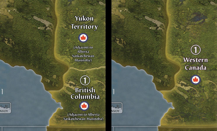
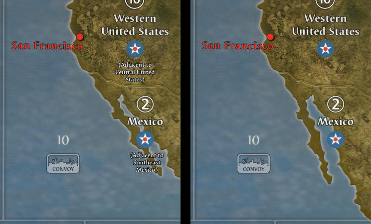
As I found a way to scan my own boards in good quality I was even able to use my 2nd edition board itself to add the 2nd edition changes to the map. See the two examples below for Western Canada and Mexico (left: original map file from YG, right: 2nd edition changes). Note that using my own scan I was able to regenerate the original artwork on Western Canada and Western United States without visible color differences.
Next stop: color correcting the visible overlaps between different scans. They are visible in the sea zones. Especially on the Pacific side of the board.
Stay tuned!
-
This map looks great! Looking forward to completion :-)
Looking at the 1st edition pacific board, I’ve also noticed that Sydney and Calcutta have the round victory city symbols rather than the square capitals symbols… at least that is what the first edition board looks like, maybe it’s rectified in the 2nd ed. Calcutta mightn’t need one since it’s part of the UK, but it is essentially a capital. I corrected this myself on YG’s board but you might want to do it on your own board.
Checked my 2nd edition OOB boards, and indeed they still have the round VC symbols. Great spot!
-
This map looks great! Looking forward to completion :-)
Thanks!
I’ve also noticed that Sydney and Calcutta have the round victory city symbols rather than the square capitals symbols…
Wow never noticed this before! Thanks for sharing this with the community. I will definitely address this.
-
This map looks great! Looking forward to completion :-)
Looking at the 1st edition pacific board, I’ve also noticed that Sydney and Calcutta have the round victory city symbols rather than the square capitals symbols… at least that is what the first edition board looks like, maybe it’s rectified in the 2nd ed. Calcutta mightn’t need one since it’s part of the UK, but it is essentially a capital. I corrected this myself on YG’s board but you might want to do it on your own board.
Checked my 2nd edition OOB boards, and indeed they still have the round VC symbols. Great spot!
This map looks great! Looking forward to completion :-)
Thanks!
I’ve also noticed that Sydney and Calcutta have the round victory city symbols rather than the square capitals symbols…
Wow never noticed this before! Thanks for sharing this with the community. I will definitely address this.
You’re very welcome for the spot… it’s what happens when you have a bored guy staring at a game board :lol:
Suggested Topics

