


v10: G40 Lite including France, aligned Neutrals, Canada, ANZAC, Communist China, and all the recent additions up to 11/18/2025
https://drive.google.com/file/d/1mBgt6KSM7oIE3uNmuESPSU2F1AhicYMG/view?usp=sharing
G40_Lite_v10_prev.jpg
Hey, guys…
I will soon be finished with my new table, perhaps you want to have a quick look…
The map is 1,2 x 3,6 meters, the table is 1,25 x 4,5 meters (incl dice trays etc)
The goal is to at least make it playable, esthetics not so much :)
It is a merry mix of train model and war gaming styles + a few puns thrown in (ex.the yellow sub out side the coast of Sweden:)
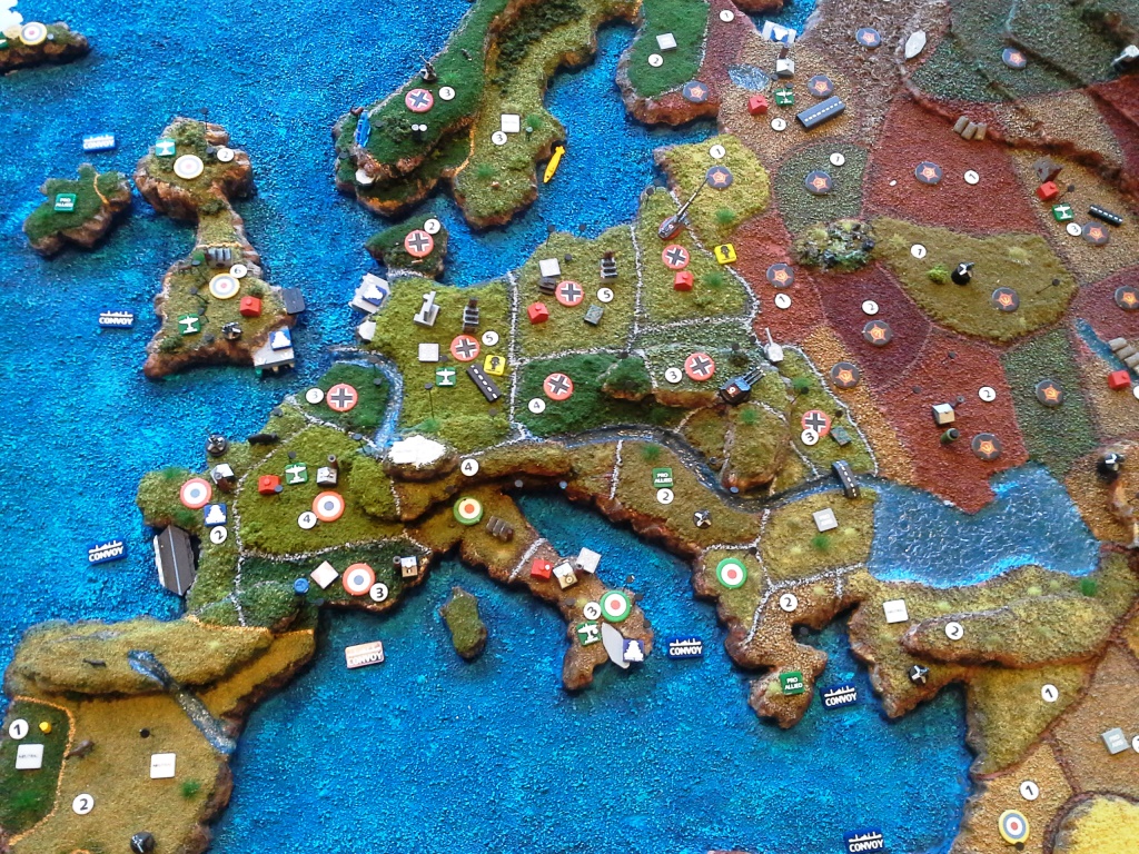
Pic-1: Europe
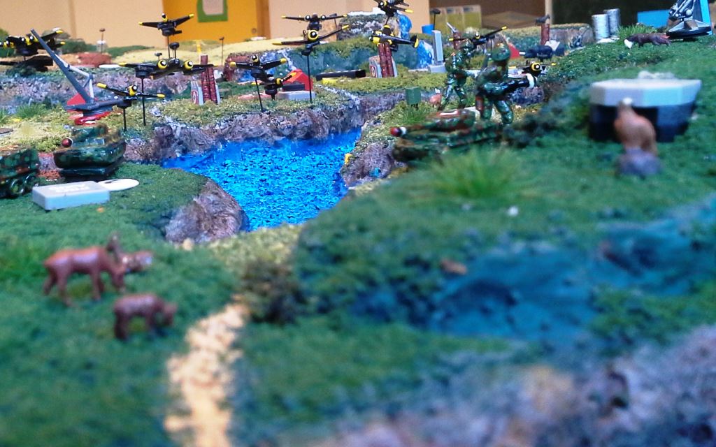
Pic-2: Looking south from north of Norway, German infantery in Sweden is carrying a panzerfaost btw
I still have to mark the sea zones and cover the oceans with water(-effects) + minor detales here and there -> I can post more pics when I am finished if anyone is interested…
Peace!
Jarl Christian / Fenris
What a novel idea! Thanks for sharing. How do you find that it affects ease of gameplay? (IPC values, recognizing territory control, etc)
Wow! It is clearly a labour of love and will give you immense pleasure whenever you use it.
Thanks, guys:)
I haven’t played on the table yet, so i still really can’t say. I mean, looking at it now is a bit different from an actual game (stress, competition mind set ect).
That being said, there is a few obvious things;
The map is enlarged by 50% but that extra area is in most places lost due to the slope of the continents/land masses (the shores so to speak). But that is why i wanted a bigger map in the first place.
Mind you, a reoccurring theme here is my complete inexperience with painting, modeling and all other craft skill needed to do this project. So i am complete open and frank about this: i just really wanted to do this, and so i did. If you go to any decent war gaming shop or simply youtube, you will find terrains one million times better than mine. But that is ok, at least for me. Its “home made” and it shows, but i feel that has a charm of its own. And not speaking of detail work and finesse, i have made a couple of bloopers that i really could, and should, have avoided, like mounting Iceland up-side down (sorry, my Icelandic friends, hope you don’t get dizzy;)
The territories are quite easy to differentiate; the border is painted in a fairly noticeable color and/or no territory is next to one with the same color. The mountains makes it a bit more difficult to see all territories (or at least which pieces are located there), especially with the Himalayas which is 4 levels high. I think this will play in with the sea zones as well; all though i plan on putting on a 1 cm thick transparent water layer, it might be a bit challenging to notice a low small submarine from a far (if it is places close to the land/shore).
I have glued on (starting) nation markers, when someone takes over a territory the new roundel is simply placed on top of the other. The territory value (IPC income) is perhaps a bit too small, but when i came round to placing them on the map, it was already a bit crowded with other things, so i felt i couldn’t use too much space:/
The convoy disruption and kamikaze markers are very easy to spot (both from HBG).
And, i have decorated the terrain with a lot of stuff, none is required for the game.I just felt like it could bring a bit of humor and picturesque details to the gaming experience. I have placed a few extra guns, that is perhaps the most questionable decision of them all (it can be confused with AA guns).
The animals, birds and fishes do take up area, but they to add another level of detail; you have fishes swimming in steams outside Japan, Peru, Norway and Indian Ocean.
For the folks in Canada: two Canadian territories have autumn leaves/foliage (orange, red, yellow), something no other territory have. And some wild moose and dears are frolicking around up there:)
India: Holy cow!
Normandy: Wild boar (Asterix and Obelix).
Norway: Rain showers over Bergen, wild dears and foxes.
Sweden: A yellow submarine at the sea floor outside your coast. It has some Russian marking btw…
Holland: the terrain is cut lower than all the other level one territories (close to the sea level)
Congo: Blood diamonds.
Germany: Gas markers (HBG).
UK early radar (from HBG)
Poland: a big ass Gustav gun (HBG)
Stalingrad: Sand bags
Iraq and Saudi Arabia: Oil derricks (HBG)
US: Eagles (with nests up on the mountain side)
and much more…
I have also added a few rivers; ganges, sein, niger, yang tze, amazonas, donau, volga, nile
These take up space, but are kinda cool :)
On most territories a have mounted pins with magnets on top; all my airplanes have magnets attached under so they can stay in the sky, leaving more valuable terrain space for the ground units. Also, i have painted rows of staples (magnetized) as air field strips, the planes can land on these as well.
The table is huge; you really have to walk a bit if you are playing a 1-on-1 game…
On each side of the map is: bank (area for money, HBG), dice trays, trays for my 1600+ painted pieces, trays for chips, dice and battle markers.
Battle markers is a stack of chips glued on top of each other, black under and bright orange on top; is it placed where ever you declare a battle, either with/with out a dice rolling battle, meaning all combat moves, with the orange facing up.
You can’t help but noticing them, so it really is a good visual aid for us new comers; haven’t forgot/missed a battle in Africa since we started with these…
When battle is resolved, you flip it black side up. When you collect income (and move planes in the non-combat round) you know, and notice, the newly taken territories.
i will take some more (high resolution) pics in a week or two, there a lot more to see:)
Oh, and this should probably be said in a different thread, but i could not have done this without inspiration from people on this forum…what a great place to be for a customizing freak like me :)
peace…
Wow, this is truly amazing. When your done, let us know how it goes when you play your first game. Again, super amazing job.
Cheers! :-D
John
I’ve seen a 3D map before, but instead of actually trying to play ON the 3D map, they secured a piece of plexiglass OVER the 3D map, and used the playing pieces on the plexiglass, solving all “3D problems”, but still able to view and appreciate the 3D map… just a thought.
Wolfshanze: sounds cool, that would probably be a bit safer when it comes to spilling ect…which is going to be an issue with my table :/
working on the table at work, due to summer holidays i cant continue untill mid august, i’ll post finished pics then…
Fenris

