


It’ll never happen, it says right on the box “limited edition”… oh wait… nvm…
IL's Big Map
-
I downloaded and printed IL’s large map (phase 1) a few months ago and wrote out this list of changes that I think should be made (and have finally got around to posting them). Although I think this map is really good, and looks quite professional for the most part, I think there are a few things that can be changed (and some things that have been overlooked) to make it look more professional.
To clarify my meaning for some words I’m about to use:- over colour means the thin line in the borders and under colour means the thick line in borders. Sea-line means the border where land meets sea.
–-----
GENERAL
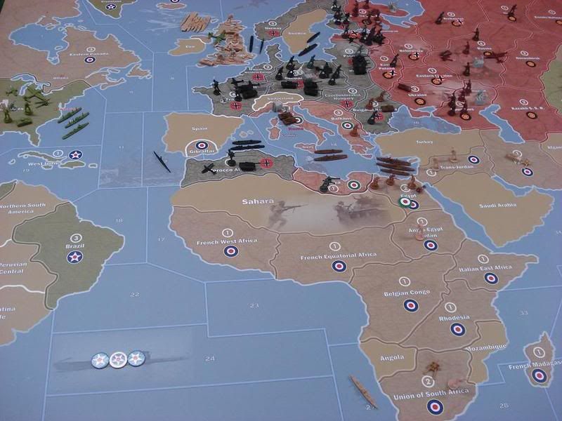
–-----The M in Mosambique is obscured
There are solid white borders around Switzerland, Spain, Peru, Eire (should be changed to a two-tone border to match all other borders)
There are single colour border Afganistan (thick), Himilaya (thin) (should be changed to two-tone)
Neutral borders should have similar colours to UK borders (both under and over colours)
French Indo should have Jap colour northern border
Change Jap border (over colour) to something darker (burnt orange?). The current bright border really stands out over all the other sombre borders on the board.
Change Italy’s border under colour to same as Britain’s (Italy’s is currently white)
Change China’s under colour to USA’s under colour (China’s is currently white)
USA’s sea-line is noticably whiter than other sea-lines (especially on the West coast of USA) {Not all that important}
Some places are missing their sea-lines - Sahara/sz17, Fukien/sz61, the Karelian inner sea, Hawaii/sz53
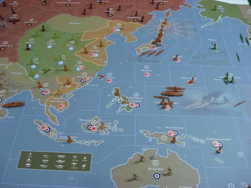
Missing Islands - Iwo Jima, Wake, Okinawa, Caroline Islands
Hawaii should have an Island chain for better representation {Not all that important}
Western US needs to be stretched out vertically to equal the Eastern US borders (using the wrap-around as comparison), as does sz 55. The only borders that matche in the wrap-around are the sz21/25 border on the left of the board and sz43/44 on the right of the board. (eg. The Eastern USA territory is longer vertically than the Central USA territory)
Remove all northern snow (arctic). If not, at least use sea-lines between snow/land for conformity
The word ‘Sahara’ needs to be placed over the pic in the Sahara territory. At the moment the pic is slightly obscuring the word ‘Sahara’.
Put a white 1/2 inch border around the entire map (any colour, really, but white would look best IMO)
I think you should put your name and/or website somewhere on the map, but that is entirely up to you, ofcourse.
CAPITAL CITIES
–--------------------------Rome has red writing with dark outlines while all other cities have red writing with white outlines. I personally think that the Rome writing looks better, and that you should change the other city names to match that. But if you prefer the red with white outline, then you’ll need to change the Rome writing to match that.
Washington font size is smaller than all other capital names
SPECS BOX
–-------I think you should create a header in specs box (Attack-Defend-Cost) so newbies to the game know what the numbers mean at a glance
Factory should be labelled 0-0-15
Move specs box to where photo of leaders is (sz31/32), above the Axis & Allies title. Remove photo of leaders. IMO, it makes the board look amateur when the rest of it looks so professional (ie. it detracts from the overall aesthetics).
IMAGES
–----- Some images need to be faded in to look better
- Some images would look better if you use the territory borders as borders of the image (ie. crop the image to fit within the territory)
Images that look good as is:
sz14, sz15, sz16, sz11/12, sz2, sz3, sz45, sz57 (get rid of flak in sz59), Jap flag & US fighters in sz62/58 (I really like the symbology with that overlap - good job)
Images that need modification (ie. fading at edges, or cropped to fit territory):
sz24 (fade in)
tanks at Caucasus (fade in)
tank North East Poland (fade in)
Stalin in Russia (either cropped at shoulders to fit territory, or fade in)
Sahara Desert (either cropped to fit territory, or fade in)Needs to be moved:
sz51/53 moved left to be inside sz51 completely (create a border for image)
Needs deletion (IMO these images detract from the rest of the board):
sz54
sz61/62
sz31/32 - the leaders above ‘Axis & Allies’ as explained above
Ofcourse, you can take all, some or none of these suggestions into account as you see fit.
And to finish off this post, here are some photos of the big board:
-
IL,
If you do make any ‘fixes’, please repost the latest ‘upgrade’ link (PDF)
I have not yet printed my big board version, so perhaps my procrastination is a good thing in this case :)
Either way, these are beautiful maps and I am looking forwards to getting one under my game board glass instaead of using the board itself.
-
I think he got an old file.
I will carefully look at what he says and produce a perfect revision.
I would be honored to have anybody use my map. Its made for playing the game better because in reality its much easier to devise the strategy when the spacial relationship of the spaces to pieces is different like i got it.
I have no idea why my sentences always start with I.
Ill try to work on that.
-
OK you definatly have an older version of the map. I can clearly see some of what you got has been fixed.
Sorry. Let me check it completely and post the most recent version corrected if necessary.
-
@Imperious:
OK you definatly have an older version of the map. I can clearly see some of what you got has been fixed.
Sorry. Let me check it completely and post the most recent version corrected if necessary.
Yeah, I had a feeling you may have updated between then and now. Just for reference, I got the map I currently have from this thread (second post on page 3).
cheers
-
Well it turns out something in between is the answer, so i made final corrections of which i did about 3 out of 4 things you mentioned.
one thing that does not make sence is to align the two sides of USA for wraparound because nobody needs this.
The border idea to me is a waste of money because it costs on average $10 bucks a sq foot for printing and that adds up to wasted space printed. If you really want a nice border i can easily make one just for you.
The Washington font is smaller because where it was didnt look correct with the larger font sitting in the ocean. The names of places are essentially in the same places as the map to keep it similar enough to be comfortable.
I got no fewer than 10 emails saying how much people love SPECIFICALLY the picture in the Sahara. I think it was strange to hear that, but ill take it as a measure to just leave that thing alone.
Thanks for scrutinizing the map. I know it took alot of time for you to make it so complete, which is part of the reason why i went back to make changes.
I added my name to the file, but i don’t like this because its not about me but i have seen a number of incidents of people taking my maps and claiming as their own like they “reworked the basic map” I don’t care about this for myself but its kinda ridiculous sometimes.
lastly, i am surprised you didn’t mention that i NAMED: Sicily, Sardinia, Ceylon and Corsica, but i refuse to treat my Italian and Indian friends with such disdain. I will never make any map that would not bother to name such important areas. Malta should be on the map as well. It was HUGE to the allies!
I can also make a version that has the player aids on the side ( probably the pacific side) so players can mark stuff and have a thicker battle board. Ill wait for inquiry’s on that before i proceed.
here is the file in PDF: (80 MB)
-
When this map is printed out what are the dimensions?
Is it practicable to print it out using the 8.5X11 full size label sticky backed pages and then securing it to foam board?
Does anyone know how many 8.5X11 sheets it would take?
Thanks a lot, it looks great!
-
its 60x36 and yes you can tile it and print on sheets and tape together, but it will kinda look cheesy.
-
Hey IL. Thanks for taking some time to implement some changes. I’ll download and check out the new map tonight.
one thing that does not make sence is to align the two sides of USA for wraparound because nobody needs this.
Yeah, this isn’t all that important since there is plenty of space in the territories. I just thought it was strange that they weren’t initially lined up.
The border idea to me is a waste of money because it costs on average $10 bucks a sq foot for printing and that adds up to wasted space printed. If you really want a nice border i can easily make one just for you.
I was thinking that it would be easy enough to shrink the map by 5% (or less) so that adding a border would still leave the surface area the same size. I don’t know much about these type of graphics so I’m unsure if it as simple as I thought it might be. Again, having a border isn’t all that important anyway, it’s just that after playing on Bionic Donkeys AAR board (which has a border) I thought it would make the map look neater.
The Washington font is smaller because where it was didnt look correct with the larger font sitting in the ocean. The names of places are essentially in the same places as the map to keep it similar enough to be comfortable.
Fair enough.
I got no fewer than 10 emails saying how much people love SPECIFICALLY the picture in the Sahara. I think it was strange to hear that, but ill take it as a measure to just leave that thing alone.
I think you misunderstood what I meant in regard to the pic. I like the pic too. What I was saying is that the word ‘Sahara’ was placed first, then the pic was placed over the top of it (half of it, anyway). This means that the word ‘Sahara’ doesn’t look clean. You can kind of see it in the pic I posted, but I’ll get another closer pic to show you what I mean. The other thing I mentioned about the pic was that the edges should fade in (even just a few millimetres), but that is of course up to you.
lastly, i am surprised you didn’t mention that i NAMED: Sicily, Sardinia, Ceylon and Corsica, but i refuse to treat my Italian and Indian friends with such disdain. I will never make any map that would not bother to name such important areas. Malta should be on the map as well. It was HUGE to the allies!
Yep, I really like what you did with naming the islands. The reason I didn’t have that on my list is ‘cause my list was of thing I thought should be changed. :wink:
Thanks for scrutinizing the map. I know it took alot of time for you to make it so complete, which is part of the reason why i went back to make changes.
Thank you for making the map, and a big thank you for taking what I wrote into account and making changes you were comfortable with.
Cheers!
-
I was thinking that it would be easy enough to shrink the map by 5% (or less) so that adding a border would still leave the surface area the same size. I don’t know much about these type of graphics so I’m unsure if it as simple as I thought it might be. Again, having a border isn’t all that important anyway, it’s just that after playing on Bionic Donkeys AAR board (which has a border) I thought it would make the map look neater.
Yes i can do this, but your paying extra for wasted space that does not aid play. I can still make any border you like just for you, but i think the additional professional appeal may be less desirable than maximum playing surface.
Also , i moved Sahara and if its not right i can move it or change it.
Im sorry you printed out a less than perfect map, but at least i got it better for the next guy.
-
@Imperious:
Im sorry you printed out a less than perfect map,
No, don’t be sorry mate. I’m happy with the map I have and am glad you put in the effort to give it to the public.
but at least i got it better for the next guy.
Yep, that is the reason I compiled the list. Thanks again! :-)
-
Good sir I am in awe of you work, this is mighty
Afro for you as you are that cool :mrgreen:
-
@Imperious:
Im sorry you printed out a less than perfect map,
No, don’t be sorry mate. I’m happy with the map I have and am glad you put in the effort to give it to the public.
but at least i got it better for the next guy.
Yep, that is the reason I compiled the list. Thanks again! :-)
I second this post.
Thanks for your efforts IL. Your passion for the game is pretty much unparalleled. I am looking forwards to blasting through a print cartridge (or two) to make my map.
-
ok thanks!
-
IL
just how may hours did you spend on making the map?
Man, it is something else to behold.
Are you a cartographer by trade?
-
-
no i play badminton by trade.
-
Anyway you can email me a JPG or BMP of your map to isfcco@hotmail.com, IL?
Or, failing that, just the purty pictures in the Oceans? Love to incorporate them into the AA-1941/1942 maps for Battlemap!
BTW, looking for good images to replace the tiles for Battlemap too, something pretty that I can copy/shrink/paste onto the tiles. :)
-
I cant compress the PDF to a BMP or Jpeg. Illustrator cuts that off at about 11MB.
Just get the link and try to get it done on your own. i have tried everything
also im working on something special with it to add a border and all the player aids on the side. If you want a print copy wait till its done so you have a better choice. This final version of the OOB map will be the best ever.
-
ok here is the new file with border and charts. ( 84MB)
80 x 37.5 inches PDF format.
Suggested Topics

