


I’ve created a separate thread for my work on the OOB 1914 map. Please go here to discuss it in more detail.
Images of the Map?
-
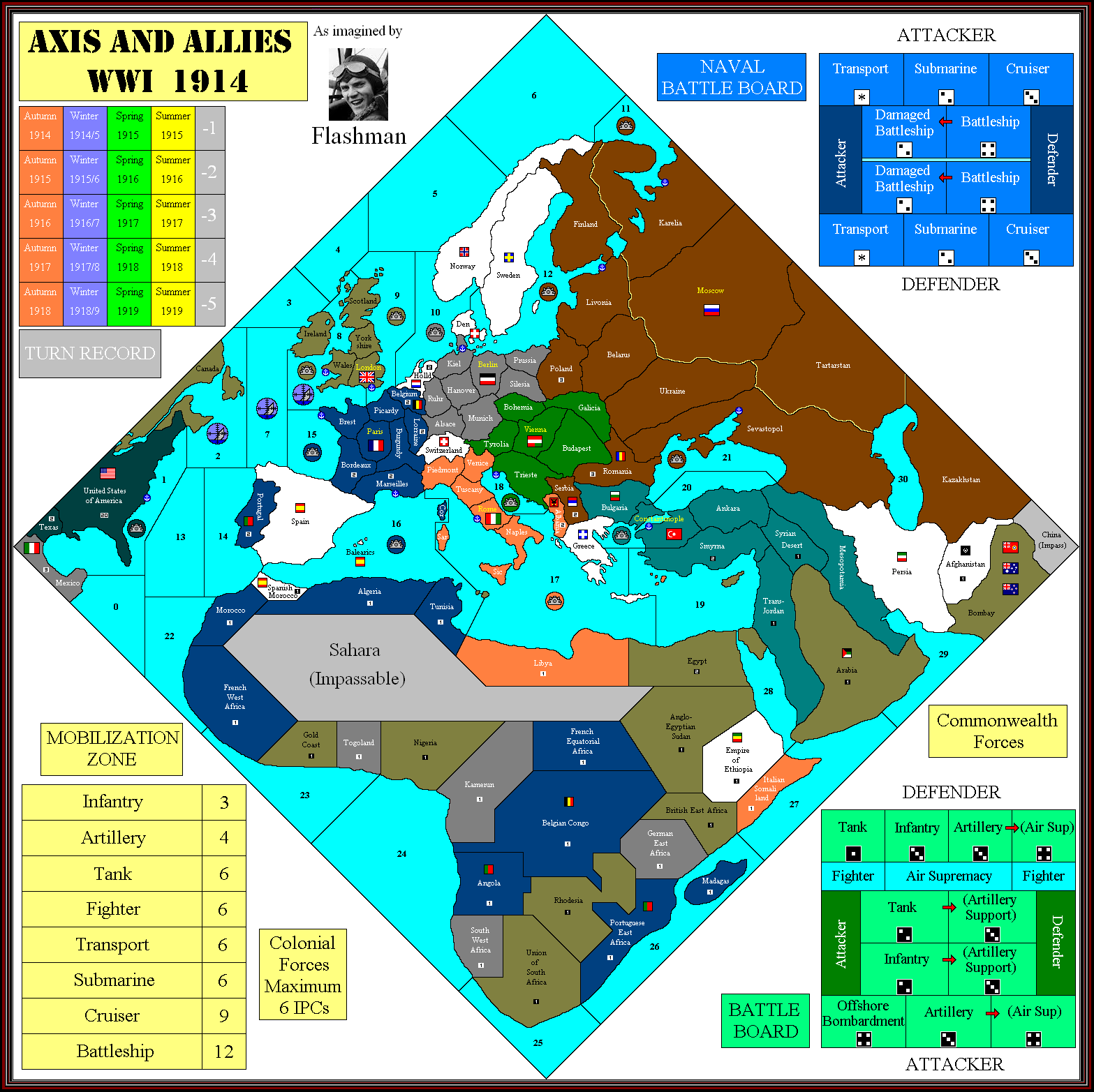
Just an idea. I think Spain is massively underpowered as a neutral. If it really does have only 1 IPC that makes it half as productive as Albania, which had no industry whatsoever.
I’d certainly give it a few more IPCs and a navy off Cadiz.
Are you suggesting Spain as a ninth player?
I see no other added power, but that is disastrously ahistorical. What can you possibly mean -
Just an idea. I think Spain is massively underpowered as a neutral. If it really does have only 1 IPC that makes it half as productive as Albania, which had no industry whatsoever.
I’d certainly give it a few more IPCs and a navy off Cadiz.
And the power to unleash the Spanish Influenza.
-
And the power to unleash the Spanish Influenza.
Ha! Roll two die per unit. “Snake eyes” means death.
Yrs.,
R. -
-
Here’s a printer-friendly version of the map Flashman uploaded, for those of you who’d like to playtest the map without using a gallon of cyan.
Yes, it’s a little “Easter-y,” and we’re still missing many of the IPC values, but if you want to get a rough feel for how the game plays, here you go.
P.S., If someone can figure out how to format this so it prints out on 8.5"x11"'s, that’d be awesome.

-
Is there an easy way to rotate it so you get more on the paper; don’t know if the image is quite square.
-
Is there an easy way to rotate it so you get more on the paper; don’t know if the image is quite square.
I can rotate it in MS Photo editor, but it tends to distort the pixels a bit.
Edit: Here it is.

-
Nice, I quite like that look. Do one for me when I get the map finished!
-
Here’s one where I upped the resolution and “printed” it to a PDF, should be able to just print it out on standard paper. Might be a bit big (like 42" instead of 36") but close.
-
I’ve started a new post here (http://www.axisandallies.org/forums/index.php?topic=30159.0) with my setup on the printed board. Not too shabby!
-
Slight revision of the map, I’ve put the Finland border where it should be after noticing a line I hadn’t seen before.
What I can’t see is the SZs in the north; is it possible that (ref my map) SZs 6 & 11 are one, and that SZ 11 actually lies between 10 & 12? Seems rational, but damned if I can see.
It would make a profound difference to the Allies if a transport could sail from London to Archangel in one move.
Note that Finland didn’t have an arctic coastline, in fact I don’t think it ever did.
-
Looks like the north is more like this:
Still not quite sure about the borders of Kiel-Berlin-SZ 11, though.
Thanks to DJensen for help with this.

-
Oh, nice. So Petrograd is actually in Karelia.
-
Seems so. It’s possible the Kiel-Berlin border may run down the middle of Schleswig-Holstein, but that would mean that Kiel isn’t in Kiel…
Seems strange that there are no ships in SZ 11, I assume there’s a German NB adjacent. Possibly Kiel services both SZs via the canal.
-
This is a possible solution to the contradictory information about the Kiel area:

-
The is the solution from the Diplomacy map, quite possible given the heavy influence of that game.
Denmark is considered a joint land/sea area, Ships can pass from SZ 10 to 11 via the canal.

-
Latest:

-
Flash Im pretty sure the IPC value of Constantinople is 6.
-
Question? What is with the pic of LH in Mexico?
Thanks for your maps, they have all been great. I bet your map will be better than the actual map. Will you continue to update it as we get more info and all the IPC values?
-
I want this map to be as close as possible to the production map, so Mexico had to go.
What better to replace it with?
Another note: Finland should not have an Arctic coastline (not until 1920):
http://en.wikipedia.org/wiki/Treaty_of_Tartu_(Russian–Finnish)
Suggested Topics

