


Did this game die off?
The Greater War: A Proper Map for A&A 1914
-
Hello All,
I’m announcing a project I’m undertaking to recreate the OOB 1914 map with many of the issues the community has brought up corrected. Once I design the board, I intend to post it here for feedback before having it printed on high-quality game boards.
What I need from the community is suggestions and markups of the current board; point out the issues that bug you most (Polish coastline, East Prussia, Moscow as the Russian capital, etc. My goal is to produce a map that has a roughly similar look and feel to the OOB board, with issues corrected, all while maintaining game balance as much as possible.
I’ll be drawing heavily from Flashman’s excellent work on the subject, as well as several others that have posted here.
My initial thought is to rotate the map 45o, replacing the diamond design with a rectangular one. I’ll trace the outlines of the continents (within reason) and then redraw the borders as needed.
I also intend to make my board so an optional U.S. alternate history map can be used side-by-side with the Europe Map, a la Global 1940. More details in this thread: http://www.axisandallies.org/forums/index.php?topic=30390.0
Thanks in advance for your support, and as always, I am open to suggestions and feedback.
-
To get the ball rolling,
-Poland should not have a coastline; this should belong to East Prussia.
-Bulgaria should have an Aegean Sea coastline
-St. Petersburg should be reflected as a capital and a spawn site.
-Hungary might also count as a capital territory. Some would argue with this, but the economic loss of IPCs and the political damage from its loss basically cause Austria-Hungary to crumble. It was an empire held together with baling wire. The PTR add an interesting element of economic and political collapse. A-H should be the weak political link in the CPs, just as Russia is for the Allies. And I say this as a great lover of playing the A-H empire.
-Maybe raise Bulgaria and Romania an IPC. The addition of Bulgarian resources (reluctantly given) and Romanian plunder (taken without asking) really helped Germany prosecute its war effort at a time when the blockade was starting to put the hurt on it. -
Ok, good suggestions. What do you think of my original concept of doing away with the “diamond” design? It would basically require getting rid of much of Africa. I’d also want to stretch out the Western Front territories a bit; as several people have pointed out, they get pretty crowded late-game.
-
Ok, good suggestions. What do you think of my original concept of doing away with the “diamond” design? It would basically require getting rid of much of Africa. I’d also want to stretch out the Western Front territories a bit; as several people have pointed out, they get pretty crowded late-game.
I’m a bit torn on this one… I see the benefit in having both styles of map (obviously not in the same physical map). The OOB version including Africa takes in some of the colonial warfare, but the small Western Front seems to be the prevailing complaint. What about the German colonies in blow up boxes? I’ve seen some WWI games do this. This might even be a good way of including the USA, as you really don’t need all of the North Atlantic; most of the U-boats didn’t even go out that far (some could and did reach the USA, however)
-
This is a very interesting project. If you are planing on this new Europe map working in conjunction with your alternate history USA map, you are pretty much forced to dump the diamond shape aren’t you? I for one would like to see Africa stay in tact if you can, just shrink in down so these maps might be used for other scenarios later. Keep an open mind so you could add the Pacific portion as a 3rd map linking them all as one big world map later. I would think this new project/map would have rail lines, but don’t over do it lol (spiderweb effect).
To get the ball rolling,
-Poland should not have a coastline; this should belong to East Prussia.
-Bulgaria should have an Aegean Sea coastline
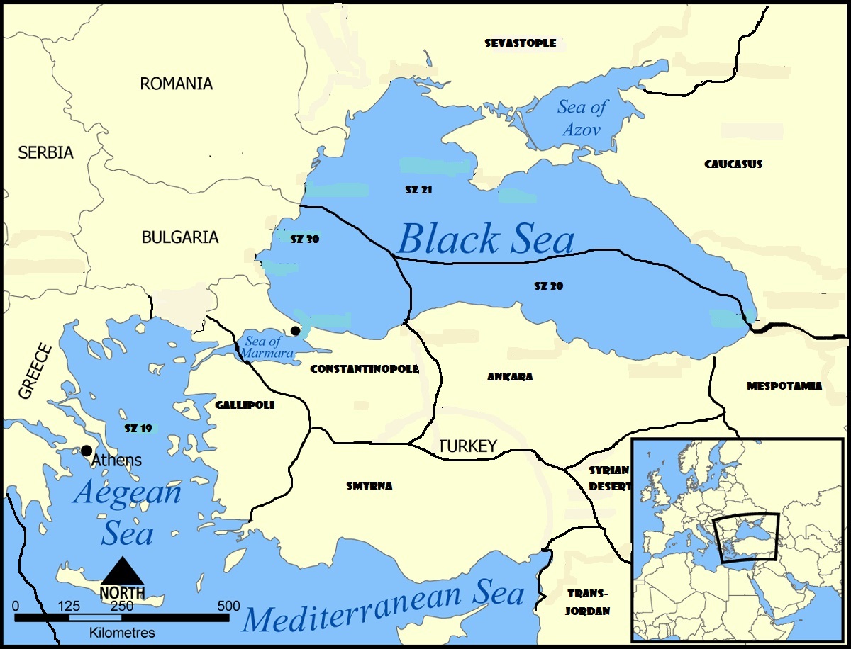
-St. Petersburg should be reflected as a capital and a spawn site.protevangelium has some great suggestions, but what I was most disappointed in was we finally got a game that included Turkey (w/multiple territories), and the map/rules omitted the importance of the choke points of the Dardanelles and Bosporus straights. I would also like a couple more sz’s in the Med (split up sz17), and maybe a 3rd sz in the Black sea as well that circles out and borders only Constantinople and Bulgaria in the Black Sea. Enlarge this area and slit-up sz20 into maybe 3 sz’s, and splinter off a part of Constantinople to make a new territory that would include the Gallipoli Peninsula and the NW corner of Asia Minor (so the allies can’t attack the Turkish capital from the Aegean, they have to first capture this new territory to gain passage through the Dardanelles).
1a) The territory of Constantinople controls passage though the Bosporus straight (splitting 2 sz’s). The Black Sea side I will call sz30, and I like I said this new sz would circle out and border only Constantinople and Bulgaria splitting the Black Sea into 3 sz’s (30, 19, and 20). The Marmara Sea would be sz31.
1b) Split up the territory Constantinople so the allies can’t attack the Turkish capital from the Aegean (I want a Gallipoli campaign as the first step to taking the Turk capital by sea). Splinter the southwestern portion of European Constantinople (including the Gallipoli Peninsula) to create a new territory that would run the Turkish Aegean coastline from the corrected Bulgarian border in the north, and include the northwest coast of Asia minor in the south. This new territory separates sz31 (Marmara Sea) from sz32 (Aegean Sea) giving passage through the Dardanelles.
With this set-up the Turks would be able to drop ships in either the Black Sea (sz30), or the Marmara Sea (sz31) and get mines for both. The Allies would need to capture and hold this new territory (Gallipoli ?) to come through the Dardanelles and it could go back-n-forth for some time keeping the allies out of the Turkish Capital.
- The Danish straight should also be considered (although Denmark starts neutral), and “The Rock” should also have some importance controlling the sea routes in/out of the Med (not part of the orig game?).
-
Why not post a map showing your proposed changes?
Just copy one of Chacmool’s or my own maps and paste it into PAINT, then make your changes.
-
I think he might want to go rectangular with it.
-
I would agree with the above points on straits in the game. The Black Sea straits should be difficult to move through, and an additional sea zone would enhance the effect.
The Denmark straits should be offset by allowing the Germans use of the Kiel Canal to move from the North Sea to the Baltic. German ships could make the transit in about a half-day. Control would obviouisly be contingent on control of the land territory.
Maybe instead of rail lines on the map, place indicators of where rail CANNOT go. Africa oviously had railroads, but between territories, they were virtually nil. Egypt and Sudan maybe?
Africa, in general can shrink in size.
The Chacmool/Flashman maps added Mexico, which was a good addition. Adds an an element of would-if and makes Mexico a serious annoyance for the USA. The U.S. would probably have prevailed in the end, but not before being bogged down in a great deal of guerrilla fighting. Nothing unites a nation faster than an invader.
-
Why not post a map showing your proposed changes?
Just copy one of Chacmool’s or my own maps and paste it into PAINT, then make your changes.
I’m sort of going for a higher production value than Paint…see my posts in this thread (http://www.axisandallies.org/forums/index.php?topic=30390.15) for sort of the effect I’m trying to achieve. I want it to look just like the OOB map, with corrections.
As far as rail lines go, I would really like to avoid putting little lines all over the map, unless of course the consensus among the community is that they are necessary. I would much prefer a rule that simulates rail movement though, and I think the PTR are a good start.
-
Think Flash was talking to me (here is my crude attempt).
I would like to see the coastline of the Turkish Capital (Constantinople) removed from the Aegean Sea. Create a new territory that I named Gallipoli that would include control of the Dardanelles Straight. This would force the allies to take Gallipoli before they can amphib through the Dardanelles Straight directly into Constantinople (like if/when the US comes that way). The Turks capital where they mobilize units is adjacent, so I think they might be able to defend Gallipoli w/o exposing their capital by sea.
The new SZ30 would include the Sea of Marmara (like the picture) and have mines.
Optional:
I don’t see the Russians amphibing from the Black Sea side (they don’t start w/transport), but they do attack the Turkish fleet often. So you could also create a special rule giving Constantinople control of the Bosporus Straight and essentially split sz30 into 2 sz’s (sz30a, sz30b). Whomever controls Constantinople controls the straight. So while the Turks are in complete control of their capital (not contested) they can shield their navy from the Russians in the Black Sea by placing naval units in the Sea of Marmara (which is just an extension of sz30). I didn’t include this in the picture because I felt it might be overkill, and possibly an unessential rule complicating things (but would be pretty cool).Also note the extension of the Bulgarian border to the Aegean, and I also like the thought of a Caucasus territory. The sea zones in the Med still need some work, but several ppl have maps showing a re-alinement.
-
A little overkill here; why the need for separate SZs 20 & 30?
Agree with all the other changes.
-
Yea, now that I look at it a 3rd sz in the Black sea is probably over kill (considering that the orig game only has 3-4 sz’s in the Med LOL). I was thinking along the lines that a new set-up might include a transport for the Russians/Turks in the Black Sea. Was looking to have the Bulgaria coast be protected by mines (isn’t in the orig). Also having a 3rd sz w/o mines for maneuvering would be a good (but probably should have had sz20 extend 1/2 way up Caucasus so that some of the Russian coast wouldn’t have mines as well.)
So you agree about the proposed Gallopoli territory including the Dardanelles. For the Allies to gain accesses to the Turk capital by sea from the Aegean you have to first have a Gallipoli Campaign and hold the coast (control the straight).
Do you think it is worth the effort to also include a rule for the Bosporus Straight basically giving the Turkish fleet safe harbor on either side of the Straight depending on the situation. (I think this too might be over kill because no one else gets this ability, and it could be a bit confusing). If your side holds Constantinople then sz30 would be considered 1 sz (it’s only looked at as 2 sz’s for the enemy). By having the territory of Constantinople include the Bosporus (essentially splitting sz30) the Turkish fleet could be positioned on either side of the straight for protection depending on the situation as long as the Turks control their capital.
-
Placement of the Turkish fleet on the Sea of Marmara side and you are shielded from the Russians in the Black Sea.
-
Placement of the Turkish fleet on the Black Sea side and you are shielded from the Western Allies if they hold Gallipoli (still have the Russians to worry about).
You could also give a safe harbor to the Russians in the Sea of Azov as long as they control Sevastopol (and maybe Caucasus). I know that this might not be realistic because from what I have read the Sea of Azov was very shallow (not a deep sea naval port) so it would be strictly for game play allowing the Russians to have the same ability as the Turks. It would also be cool if their was more of a convoy system in this game. Both sides did some raiding in the Black Sea.
-
-
Are we talking full-fledged rule changes or are we just changing the map around?
-
Are we talking full-fledged rule changes or are we just changing the map around?
This particular thread is devoted to SIMPLE map changes (moving a border here or there) in order to make the OOB map more accurate to the actual borders at the time. No rules changes.
-
Are we talking full-fledged rule changes or are we just changing the map around?
This particular thread is devoted to SIMPLE map changes (moving a border here or there) in order to make the OOB map more accurate to the actual borders at the time. No rules changes.
Alrighty.
The size of Tunsia, Morroco, Gold coast, and Togoland should be increased.
Angola should connect to Kamerun. I know its historically accurate the way it is now, but it just feels so strange to have two territorys so close to each other, but have to spend an entire turn in Belgian Congo.
Munich border with Switzerland should be a bit more obvious.
Another SZ that splits up SZ 17. This new SZ is connected to Sicily, Naples, Rome, Tuscany, Piedmont, Sardinia, SZ 16, and the other SZ 17. This new SZ houses all of the Italian navy.
Suggested Topics

