
@vodot Very cool customisations you did for the original map! Love your creative take on the different areas.
Posts made by Tjoek
-
RE: [AA50/Anniversary] Modular Map Overlays - Splitting Australia, the Balkans, and Sea Zones; adding Cairo, Malaya, Singapore, Rio, Cape Town, Recruitment Centers and tons more!posted in Customizations
-
RE: Tjoek's 1940 Global Map file and setup charts (Updated May 30th 2018)posted in Customizations
@Imperious-Leader said in Tjoek's 1940 Global Map file and setup charts (Updated May 30th 2018):
@Tjoek 1942.2 is the current flagship game of AA. its being played alot more than 1940, which is my favorite. but i readily admit whats more played and talked about
I’m sure you’re right as it’s a bit more accessible than the bigger Global 1940 I prefer too.
-
RE: Tjoek's 1940 Global Map file and setup charts (Updated May 30th 2018)posted in Customizations
@Imperious-Leader As I work with high quality scan from the original board as the basis, I have to check if I have the 1942.2 game to begin with. I don’t recall as it really has been a while I played A&A.
But still it takes many many hours to clean the maps from all scanning and merging defects as I scan it in multiple pieces of roughly A4/Letter size. Before cleaning up the fold lines etc.
So long story short: no clue if and when. I’m sorry.
-
RE: Tjoek's 1940 Global Map file and setup charts (Updated May 30th 2018)posted in Customizations
@kevArs and yes Global 1940 is the most complex. Especially with the different objectives and related bonus incomes. With this implemented the rest should be straightforward. Only the 1914 contested areas is something to tackle if you’re willing to.
Does you app sync across multiple players joining the same game session?
-
RE: Tjoek's 1940 Global Map file and setup charts (Updated May 30th 2018)posted in Customizations
@kevArs it’s not about porting, more about deploying it again. But still needs some time.
Thanks for offering to tip. It’s been an intensive effort to get this retouched map. So any sign of appreciation is hearty welcomed. Just opened a ko-fi link you can use: https://ko-fi.com/tjoek
-
RE: Tjoek's 1940 Global Map file and setup charts (Updated May 30th 2018)posted in Customizations
@kevArs
We started the same way from Excel to a little VBA. Now I we have a more solid app using javascript as well. In my version you can play different versions of the game and it tracks some stats along the way.I mostly deploy it locally on my laptop or a RPi, Will see if I can open up a port an share a link with you somewhere in the future. A bit busy with other things at the moment. And it has been over a year since I played my last game. Might already by over 2 years…
-
RE: Tjoek's 1940 Global Map file and setup charts (Updated May 30th 2018)posted in Customizations
@kevArs no problem using my map for this. I’ve actually created an app like this myself as well. Just not had the time to share it here yet.
My approach is slightly different, but similar effect.
What technology / programming language is behind your app?
-
RE: Custom map for AA50posted in Customizations
@Azimuth
I second @vodot in that it looks really great! Would love to see pictures of the final printed map as well. -
RE: JJ's Axis & Allies Global (detailed) custom map file (for large scale printing) + GIMP brushesposted in Customizations
That looks like a lot of love and hard work. Well done! Great to see a new version of the map.
-
RE: Map of AAZposted in Axis & Allies & Zombies
@Chacmool @Randy_Randelman1234
Thank you for your interest. I’ve finished the 1914 map, but haven’t had much time to work on the AAZ map. I’ve managed to retouch about 20% of the folds I guess, but don’t know when I have more time at hand to finish the work. -
RE: General 6 Stars 1941 WW2 Gameposted in Other Axis & Allies Variants
@SS-GEN said in SS GEN's 1941 Global War Game:
Want to give a shout out to Tjoek for his country token list I came across redoing my map. Totally doing a rehab to map. New colors define borders. Resource tokens. LL placements
Cleaning up and better lookingThanks @SS-GEN! let me know if you need others, I might be able to get you a few more. Looking forward to see your final result.
-
RE: Axis & Allies Community Map Filesposted in Customizations
@cmmiles said in Axis & Allies Community Map Files:
@Young-Grasshopper @Tjoek @Intrepid @ambilzi are these maps still available for download? Looks like the MediaFire links are no longer any good. Thanks!
My file can still be downloaded from my original thread
-
RE: Tjoek's A&A 1914 OOB Map file (Updated February 9th 2020)posted in Customizations
@The-Plastic-Commando
Thanks for showing the results! This looks amazing.I’ve had issues getting the colours right on my local printshop so I’m actually reworking on the color correction. Glad it worked out for you. Do you know if your printshop edited the files before printing? If so do you by any chance know what they did? This might help me.
-
RE: Tjoek's A&A 1914 OOB Map file (Updated February 9th 2020)posted in Customizations
My file went to a local printshop and they expect the map to be ready in slightly more then a week. I will post pictures in comparison with the real board when I’ve received it.
-
RE: Tjoek's A&A 1914 OOB Map file (Updated February 9th 2020)posted in Customizations
@Chacmool @The-Plastic-Commando
One more update to the files:- Colors are slightly warmer
- Reduced dark contrast between some territories and new artwork for the Sahara in Libya, Egypt and Anglo-Egyptian Sudan
-
RE: Tjoek's A&A 1914 OOB Map file (Updated February 9th 2020)posted in Customizations
@The-Plastic-Commando said in Tjoek's A&A 1914 OOB Map file (Updated February 7th):
Thanks for the great work Tjoek. I plan to download and get a map printed. I’ll post it and discuss on my YouTube channel soon.
Just found your channel and subscribed!
-
RE: Tjoek's A&A 1914 OOB Map file (Updated February 9th 2020)posted in Customizations
@Chacmool @The-Plastic-Commando
I just noticed the download links where wrong. So please re download the files if you already did so.
Not a big issue, but both links had harbour icons and I cleaned up a very small border defect in Russia. You most likely won’t have noticed it anyways ;-) -
RE: Tjoek's A&A 1914 OOB Map file (Updated February 9th 2020)posted in Customizations
The map file is released!
One version without and one version with the harbours. I opted to not include the submarine icons on the map by default, but I’ve added the dark transparent silhouette as well as the Mobilization Zone as separate files you can simply overlay yourself.
Enjoy and please share pictures of your map if you happen to print one of this files.
If you have any questions or need support feel free to send me a PM or post it here.
-
RE: Tjoek's A&A 1914 OOB Map file (Updated February 9th 2020)posted in Customizations
Just for your info, the sub icon as just tried is a silhouette of the actual sub miniature from the game itself. First I thought about a semi transparent icon in white, but a dark icon looks nice as well :
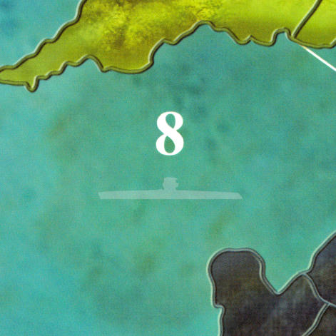
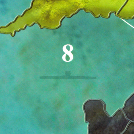
Not too busy or bold, just a slight reminder of the rule and the sea zones affected. The more I look at them, the more I prefer the dark icon as if there is a sub submerged :-)
Any comments are appreciated!
-
RE: Tjoek's A&A 1914 OOB Map file (Updated February 9th 2020)posted in Customizations
Just another question to you guys:
The Germans have the ability to declare “Unrestricted Submarine Warfare” which means that their subs in sea zones 2, 7, 8 have the ability to raid US and UK convoys. I could mark those sea zones on the map with a semi transparent icon of a sub as a reminder that these 3 sea zones are affected.What are your thoughts on this?
Update on the map
Besides I have spotted a few minor mistakes and small things I want to revisit on the map. Nothing big, but some text not being as white as it could be, some better centering of territory names and fix some text deformation that happened during stitching of individual scans: For examples the M in Mesopotamia had a small kind of wiggle in it.Expect an updated map somewhere this week.