Fixed the missing Madagascar IPC counter : http://www.filesonic.com/file/1625647404/AAEurope1940_Map_1_01(nonedit).zip
Posts made by c64
-
RE: AAEurope DIYposted in House Rules
-
AAEurope DIYposted in House Rules
You might find these links helpful if you plan to make yourself a do-it-yourself AAEurope 1940 :
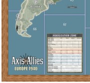
1. The map : http://www.filesonic.com/file/1625647404/AAEurope1940_Map_1_01(nonedit).zip
Preview here :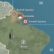
Print it out on several pieces of paper and stick them together ( use the page tiling options when printing the PDF )2. The setup cards : http://hotfile.com/dl/126125800/abd0fa4/SetupCards.zip.html
3. Naval and Air Base Markers : http://hotfile.com/dl/125266933/4031f6b/NavalBaseAirBase.zip.html
4. IPC Chart and National Objectives can be found in this forum : http://www.axisandallies.org/forums/index.php?topic=21602.0
5. The rule book : http://www.axisandallies.org/forums/index.php?topic=20856.0
6. A unit count ( just in case you care ) : http://www.axisandallies.org/forums/index.php?topic=19828.0Enjoy !
Some thanks fly out to TommieTomaat ( unit count ), Bob Mickelson ( NO Charts, IPC Charts ), wedgies ( rule book ) , IL ( previewing the map and giving feedback ) and finally to the folks at SpiralGraphics ( http://www.spiralgraphics.biz/packs/browse.htm ) with their great seamless textures.
( Finally : SetupCards+NavalAirBase+Map as a bundle : http://www.filesonic.com/file/1618530794/Setup+NavalAir+Map.zip )
-
A&A Vector Logoposted in Axis & Allies Europe 1940
Maybe you’ll find this one useful whenever you need a scalable vector logo.
The zip file contains the same logo as PDF, SVG and AI files.
Enjoy!http://hotfile.com/dl/125178530/97c7db5/AALogo_2011.zip.html
Btw : I did this for a vector version of the AA Europe 1940 map which will be uploaded in a few days.
See here :

-
RE: Would you reccomend A&A Pacific to a fellow A&A player?posted in Axis & Allies Pacific
Yes, definitely a good game but with an overpowered Japan, so expect to lose a lot with the Allies.
-
RE: Landed fighters vs. Attacking naval unitsposted in Axis & Allies Spring 1942 Edition
That CAP rule in good old Pacific always remained a mystery to me. As far as I remember you can only use airplanes that didn’t take part in any combat. Now who would let any airplane sitting around doing nothing in combat ? Japan not using airplanes in her attacks ? That’s why I never used CAP, not once.
-
RE: Problems with this gameposted in Axis & Allies Spring 1942 Edition
@aaaaaa2011:
Colors are too dark
Wait, wait, wait. AA1942 is too dark ? Then you must have a 500 W lightbulb to see anything at Revised.
-
RE: Battle Boardposted in Axis & Allies Spring 1942 Edition
Actually I do. But I play on enlarged maps, so that all the units are easy to reach.
-
RE: Battle Boardposted in Axis & Allies Spring 1942 Edition
Honestly, I never understood why you need a battleboard at all. Certainly not for small fights and if there are a lot of units involved just count them and roll the dice unit type by unit type.
-
RE: What is the typical bid, and what are some good basic strategies?posted in Axis & Allies Pacific
Isn’t it all about raising the number of VPs that Japan has to reach ?
-
RE: Convoy Routesposted in Axis & Allies Pacific
Assume that Japan controls French Indo-China and UK took the associated convoy route. Japan fights for this route and in the following sea battle all ships are destroyed. Can Japan claim the income or is the sea zone still controlled by UK ?
-
RE: Large scale AA42 mapposted in Axis & Allies Spring 1942 Edition
I don’t see the point in giving away $75 when you can get a reasonable result with a good printer, some self-adhesive film and a little spare time for less than $5. At least it’s good enough for me.
-
RE: Large scale AA42 mapposted in Axis & Allies Spring 1942 Edition
And one more idea :
I just took your old map ( around 91,5 MB) and saved it again in Illustrator CS3 as a PDF file with the option “Preserve Illustrator Editing Capabilities” unchecked.
See here ( first line ) :
This reduced the size from 91,5 MB to 16,9 MB ! Maybe you try this.
-
RE: Large scale AA42 mapposted in Axis & Allies Spring 1942 Edition
When I worked on IL’s map I also wondered why his files always reach such an excessive size. I found that you included a lot of unnecessary things like a lot of brushes from AA50. Deleting all these might help. And one more : For some reason all the paths in your map were doubled. Some were there without a fill and without a stroke. I’m not sure if this is true for your new version but maybe it helps to reduce the file size finding those doublegangers.
And finally : I really don’t understand your paragraph about PaintShopPro and RAR. What’s the relationship between a picture application and a compression format ? -
RE: Several Questions - Thank you ahead of time!posted in Axis & Allies Spring 1942 Edition
-
The fighters on the carrier are allowed to move one space to find a friendly territory or other AC. This happens after the attacker’s combat moves and before his noncombat moves. See page 27 in the section called “Fighters”.
-
If you live in a country with access to A4 or A3 paper format you could a try to an alternative to IL’s map : http://www.axisandallies.org/forums/index.php?topic=15816.0
-
-
RE: D Day Victory conditions?posted in Axis & Allies: D-Day
They keep their attack on 2 so that they are like an artillery piece.
-
RE: D Day Victory conditions?posted in Axis & Allies: D-Day
I used the zones indicated on the gameboard. Nothing special here. And I still use the rule that the airborne units can’t destroy blockhouses ( see Card #1).
Offtopic : What about your AAPacific games. Was Japan overwhelming ?
-
RE: D Day Victory conditions?posted in Axis & Allies: D-Day
After playing several times I found the one thing, that balances this game for me. I use different infantry models ( mine are painted, but you could get Russian units from AA1942 ) for the airborne units ( 6 US & 3 British ) and give them an attack value of 2. This way it’s always a tight race and seems balanced to me.
Without it it’s too easy for the Germans. -
RE: Special first turn attack advantage for Japan?posted in Axis & Allies Pacific
The only balanced game I’ve ever played in AAP is when we ignored Japan’s special first turn attack. So leave that rule in the rulebook, use the corrected setup and I guess you’ll have fun with AAP.
-
RE: Large scale AA42 mapposted in Axis & Allies Spring 1942 Edition
First quick impressions :
1. The land textures look fine. They are identical to the original map, right ?
2. The water colour is too bright for me and on the preview pictures it looks like the water is just a plain colour. No textures there ?
3. The swastika symbols are an absolute NoGo for me.
4. The “Franklin Gothic” font suits the map.
5. The Axis&Allies logo east of Madagascar is very ugly. ( may I dare to say so ? )
6. Glad you removed all that tanks, fighters, subs and especially all the silhouettes of political leaders.Apart from those few criticisms it is well done. Congratulations.