

@christophfromgermany Excellent post, Christoph! You should join us on Discord!
https://discord.gg/a7bPbWgk
A list of terrains on some of the harder-to-see land zones?
-
@trig I agree - not adjacent. My son thought it was though and wanted to move an infantry from The Northeast to Ottawa.
-
I agree also, a small corner of New England separates the Northeast from Ottawa.
-
Some rivers form the border between two territories and affect units crossing in either direction. An example is the Dnieper between Kiev and Eastern Ukraine. It doesn’t matter which side of the black border line the river runs - it’s the actual border and affects attacks from either direction.
Then there are rivers that do not form the border and only affect attacks from outside the territory, coming in. An example is the Amazon in Amazonas. If someone was attacking from Venezuela into Amazonas, they would face the river penalty. But if someone was attacking from Amazonas to Venezuela they would not suffer the river penalty.
My question is about when the distance from the river to the border becomes so large that we no longer declare the river to be “forming the border.” For example, the border of Rhodesia and Angola. Is the river denoted the Zambesi? The Lungwebungu? Is that river supposed to lie on the border? I don’t think so, but just wanted to confirm. At first, it is on the border, but then it falls away and the distance becomes too great. I would think if someone attacks from Angola to Rhodesia, they face the river penalty, but not vice versa.
What if the distance from the river to the border becomes a little smaller than that? Take the Lena river on the border of Northern Yakutia and Eastern Yakutia. I would judge the distance from the river to the border to be too far to “form the border,” but perhaps I’m misunderstanding this? Again, I’d suggest if someone attacks from Northern Yakutia to Eastern Yakutia, they would face the river penalty, but not vice versa.
But how about the Lena river on the borders of Angara, Irkutsk, and Buryatia? Now, the river is getting closer to the borders. Lake Baikal clearly separates Angara from Buryatia. It seems like the distance of the Lena from the border between Angara and Buryatia, then continuing between Irkutsk and Buryatia, should be the breakpoint for how distant a river can be from the border and still be able to define the river as “forming the border” so the penalty applies both ways. But as the Great Lebowski pointed out, that’s just my opinion, man.
-
If the river is not on the border, then the only thing that matters is where the river is in relation to the roundel:
Rule 1.1 :
“Land units that must cross river artwork in the attack land zone before reaching the roundel in that land zone are subject to river rules”
-
@noneshallpass said in A list of terrains on some of the harder-to-see land zones?:
If the river is not on the border, then the only thing that matters is where the river is in relation to the roundel:
Yes! You and I are on the same page my friend! So, my question is do you think the examples I gave are examples where the river is on the border? Is the river on the border between Rhodesia and Angola? I say no. Is the river on the border of Northern Yakutia and Eastern Yakutia? I say no. What say you? 8 )
-
@hbg-gw-enthusiast
@noneshallpass
Basically, to “form the border” a river must be on the border. The black lines that designate the border must be on either side.
The v2.2 rules say thus:
“If the river is a zone border (bounded on both sides by a border line) river rules apply to whichever side is attacking as if the river was located in both land zones.”
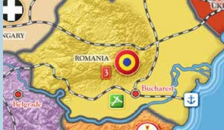
that appears to have slipped through the cracks in v3.For instance, Rumania and Bulgaria have a joint river border.
I hope that is clear.
-
@trig said in A list of terrains on some of the harder-to-see land zones?:
@hbg-gw-enthusiast
@noneshallpass
Basically, to “form the border” a river must be on the border. The black lines that designate the border must be on either side.
The v2.2 rules say thus:
“If the river is a zone border (bounded on both sides by a border line) river rules apply to whichever side is attacking as if the river was located in both land zones.”
that appears to have slipped through the cracks in v3.For instance, Rumania and Bulgaria have a joint river border.
I hope that is clear.
Oh! I never saw version 2 rules! This has blown my mind and I’ll have to revisit this tomorrow! Thanks, Trig!
-
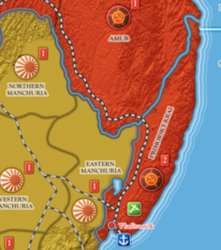
@trig So if I am reading the map correctly, the only places this rule applies are the borders between 1) Romania and Yugoslavia, 2) Romania and Bulgaria, 3) Amur and Northern Manchuria, 4) Amur and Eastern Manchuria, and 5) Amur and Primorsky-Krai. Do you see any other rivers that are actually ON the border?
-
@hbg-gw-enthusiast I believe that is correct. They are only really on areas where an international border is a river. Otherwise the river just choses a certain territory.
There might be others, but not that I saw.Note: That (international borders with rivers) does not include territories like Belgian Congo, Mexico, or Argentina, where is river is in the wrong spot or missing.
-
FAQ up on Macedonia:
Q: Is Yugoslavia adjacent to Thessaly?
A: No, Macedonia is between.
Suggested Topics

