

Re: Sired's Map project - Updated- 4/16 - files available see first post
Anyone who knows if it was intended that Sired blood changed the IPC of Celebes from 3 to 4 on his OOB map?
AMBIZI’S G40 MAP FILE:
https://www.mediafire.com/view/4ctvqjbd1v1llyu/Ambizi’s_G40_Map.jpg/file
INTREPID’S G40 MAP FILE:
https://www.mediafire.com/view/9izx2tv4303ekbu/Intrepid’s_G40_Map.jpg/file
CYANIGHT’S G40 VARIANT MAP FILE (BASIC):
https://www.mediafire.com/view/7hnn8t33flpr6s3/Cyanight_Deluxe_Edition_(Basic).jpg/file
DON’S G40 MAP FILE:
https://www.mediafire.com/view/sdfftg7s74aff0o/Don’s_G40_Map.jpg/file
TJOEK’'S 50AE MAP FILE (BASIC):
https://www.mediafire.com/view/tou40v6acgx6zef/Tjoek’s_50AE_Basic_Map_File.jpg/file
TJOEK’'S 50AE MAP FILE (ADVANCED):
https://www.mediafire.com/view/nivn2vceem5uw1x/Tjoek’s_50AE_Advanced_Map.jpg/file
GRASSHOPPER’S G40 TOURNAMENT EDITION MAP FILE:
Coming Soon
DON’S DE40 DELUXE EDITION MAP FILE:
https://www.mediafire.com/view/vwqn9iooerp3rh5/Don’s_DE40_Deluxe_Edition_Map.jpg/file
GRASSHOPPER’S 41 ACADEMY EDITION MAP FILE:
https://www.mediafire.com/view/ecl21vopw7rj643/Grasshopper’s_Academy_Edition_Map.jpg/file
Hello everyone,
Many years ago a member named Ambilzi began the tortured task of scanning all the A&A G40 game boards in order to create a printable one piece map file which would provide a better G40 gaming experience. He didn’t know it at the time, but what Ambilzi did was revolutionized the way we play Axis & Allies, and also provided an essential customization for any custom game table. I was fortunate to work with Ambilzi simply because I reached out made some design suggestions which he was very open to, and the list of those first modifications really tell the story. I shared some ideas that made the map more efficient during games, but Ambilzi was the true pioneer when it come to the history of this file because of the effort he undertook to scan and stitch all those images together. We don’t here from him anymore, he doesn’t, won’t, or can’t return our messages… but his efforts should never be forgotten.
Since then there have been many of us that use his scanned image file to modify, tweak, and reinvent how it looks, and how we think the map should function. Whether we print this map for our own gaming pleasure, or to modify it and share our ideas with the community, we all owe Ambilzi a great deal of gratitude. Today we can enjoy even better works and map files by those that dedicate their time and skills to improve upon the original scan. Customizers like Cyanight who created many versions mostly dedicated to options for the roundels, Ithaut with his creative ocean layer, and intrepid who cleaned up many imperfections that only his professional eye can detect. In the coming months we await the works of new customizers like Siredblood, and Tjoek… they may use the base scan or create their own map files from scratch, but one thing is for sure… the Axis & Allies community thanks all of them for their efforts.
Thanks for the acknowledgement, YG. You forgot the most important fix (at least for the people who live on Iwo Jima) � their island is no longer upside-down in the Pacific! :-D
YG, you’ve been the visionary behind this map project over the years, so thank you for the innovative ideas, and for always striving to make the map better.
Technical note: This map file is sized 72"x33" at 300dpi.
Thanks for this one guys.
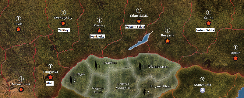
Certainly too late, but if anyone is willing to correct a few names here is the best accurate names for each Territories in Siberia, I found this by looking upon DK’s AA50 inspired map.
Chelyabinsk (Tankograd) is a more WWII fitting name for this TT between Urals and Yenisey.
Tunguska can be replaced by Altai, as a more appropriate region to pass from China to Novosibirsk, USSR, or Mongolia.
Another simpler switch: Yenisey become Evenkiysky and Evenkiysky becomes Yenisey.
However, it does not solve Yakut SSR and Sakha issue, being one and the same region and political entity.
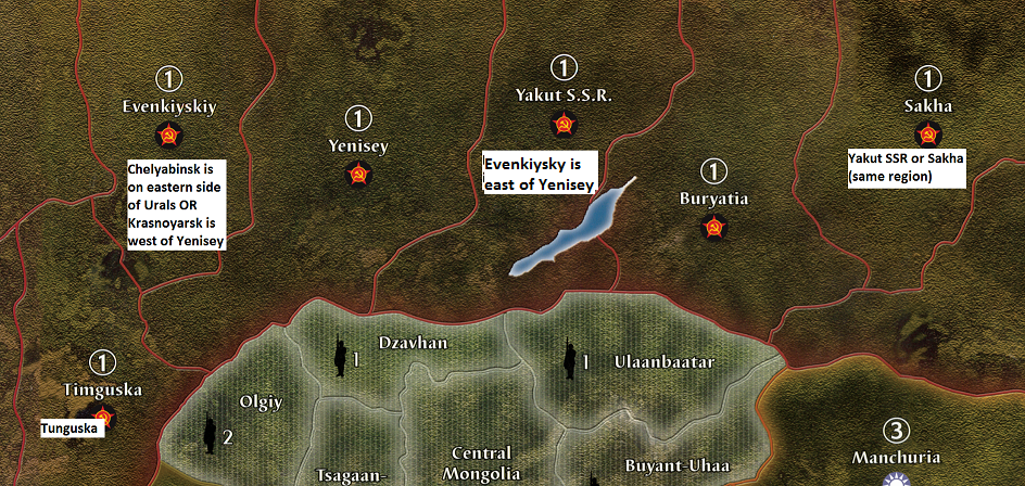
Here is the switch and a different way to solve Sakha issue.
This erase Tunguska for a more realistic Altai being frontier to China, Mongolia and Novosibirsk.
However, Tunguska TT being south of Yenisey TT on this map is not a bad choice, but not as accurate as Altai.
Pushing westward Yenisey is also a way to rightly mark the north-western end of 1940 Pacific map.
As read elsewhere, Axis partners agree to stop at Yenisey river. West of Yenisey was for Germany and east for Japan.
So, it was a kind of agreement that Urals TT is to be Germany while Yenisey TT to Japan.
These maps are above and beyond great! Is there any experience blowing these up to the 96x45 size? I would imagine they should look fine but wanted to hear from experience.
I would also like to know how well this image scales up. Maybe not quite as large as carsonbparker mentions, but perhaps 80x36 or something similar.
I am trying to view these and or get a copy of these from my work computer. I do not have access to Mediafire. How else can i get a copy or better yet at least view the image to see if its what im after.
carsonbparker and Navymule, the map should scale up just fine… the resolution might drop to the 200dpi range, but it should still print a crisp image.
Here’s a low-res shot of the map…(without ghost boxes)

Is there a way to get this file without having to deal with mediafire?
What a pain.
Is there a way to get this file without having to deal with mediafire?
What a pain.
What exactly is the problem you’re having with mediafire?
@Young:
Is there a way to get this file without having to deal with mediafire?
What a pain.What exactly is the problem you’re having with mediafire?
Disregard, I was clicking “view” and it was putting me through the ringer. I assumed “download” would do the same. I got it now.
@Young:
Is there a way to get this file without having to deal with mediafire?
What a pain.What exactly is the problem you’re having with mediafire?
Disregard, I was clicking view and it was putting me through the ringer. I assumed download would do the same. I got it now.
Ya, the view file option doesn’t seem to work for these files on Mediafire… hit this link to see a bigger selection of maps. https://www.axisandallies.org/forums/index.php?topic=41411.0
Hi all,
the maps are just awesome!!!
I’m working on a map variant myself and I was wondering if someone would mind sharing the psd file?
I need to edit country-attribution (nation colors) and other smaller things.
thanks so much for you help!
cheers,
Loig
Has anyone run into issues with getting items with these maps on them printed? Isn’t the work copyrighted? Or have they given folks permissions to print them?
Larry Harris was at YG’s tournament with maps printed….no problems…you’re good to go printing them
Has anyone run into issues with getting items with these maps on them printed? Isn’t the work copyrighted? Or have they given folks permissions to print them?
I think you’d only run into trouble if you tried to sell them after printing them.
That makes sense. Some printers (like The Game Crafter), won’t let you print things if you don’t have permissions to use any of the art…and this map being created from the real map meant I might not be able to print it. I modified the coloring slightly so I could do an overlay and it made it through…its a bummer though that I would have to make my own version of the map to sell prints. Oh well. (I made a custom map based objective tracker for AA50).
Is there any blank 1940 maps so i could mess around with it?
LMFAO. Blank? Thats funny

