DK's Hybrid Axis and Allies Map and Rules


  • @Trenacker:

    DK, by helping me out in Photoshop, you just made my year. I’ve been trying for months to figure out how to make my draft map print-ready. Thanks again!

    That’s great! I hope we get to see your map when it’s done!

  • '16

    Rounding out the cities on the map, which will be small(ish) circles.

    DK, may I ask how you added roundels to the map? I’ve found a few online, but the resolution is ruined when I try to paste them into Paint or PhotoShop. They also usually come with white or dark backgrounds that must be removed or painted over.


  • I remember some of them I used were already on IL’s map that I started with. I think I made Germany’s from scratch in Photoshop because it was pretty easy. Some of the countries you can find the high resolution square flag and then take a circle out of it.


  • Uploaded the latest version 1.2 of the map we are using. This map contains the East Front territory changes, divides France in half, and gives a capital to China as shown in my “Map Patches” video on you tube.

    https://www.mediafire.com/file/m7xudoypp1sqnjp/DKs HYBRID AA Map (1.2).pdf

  • '17 '16

    Thanks DK.
    IMO, to be as accurate as you wish, you should compare your China map with real ones and revise names according to better geographical location. Not just follow Global one on this. Looking at AA50 map may also give you some hints about how designer try to solve some Chinese toponymes issues. When I looked at it, I’m pretty sure you can reach better compromises than Global map.

    To name just an obvious case:

    Chongqing was also a Sichuan province municipality during the Republic of China (ROC) administration, serving as its wartime capital during the Second Sino-Japanese War(1937-1945).

    Wikipedia

    Sikang is not in Southern China bordering only Tibet. Chongqing cannot be the capital city of Sikang.

    Xinjiang borders the countries of Mongolia, Russia, Kazakhstan, Kyrgyzstan,Tajikistan, Afghanistan, Pakistan and India. The rugged Karakoram, Kunlun, and Tian Shan mountain ranges occupy much of Xinjiang’s borders, as well as its western and southern regions. Xinjiang also borders Tibet Autonomous Region and the provinces of Gansu and Qinghai.

    Also, it is too bad I just noticed a misspelled Eastern Ukraine (Ukrane!)…  :cry:


  • Good points, Baron. To me, Chinese territory names and spelling are confusing and seem to change depending on what time period you are looking at and what reference you are using. Are they named for a landmark, a city, a region, etc? When naming Chinese territories perhaps it’s best to drop a bunch of silverware on the floor and write down the result - you get Chung, Chang, Ching, Chong, etc. lol


  • @Der:

    Chinese territory names and spelling are confusing and seem to change depending on what time period you are looking at and what reference you are using.

    With good reason.  The old Wade-Giles system for transliterating Chinese into English was replaced at some point by the current Pinyin system, which is why (to give just one example) Peking is now known as Beijing.  To complicate matters further, some place names in China have changed since the Communist Revolution for various administrative and/or political reasons.  I recall reading an article by an American zookeeper or zoologist who was visiting China around the 1970s or so, and who got a dirty look from his Chinese hosts when he referred to a “Manchurian tiger.”  He was told politely but firmly that this animal is properly called a “Northern Chinese tiger.”

  • '17 '16

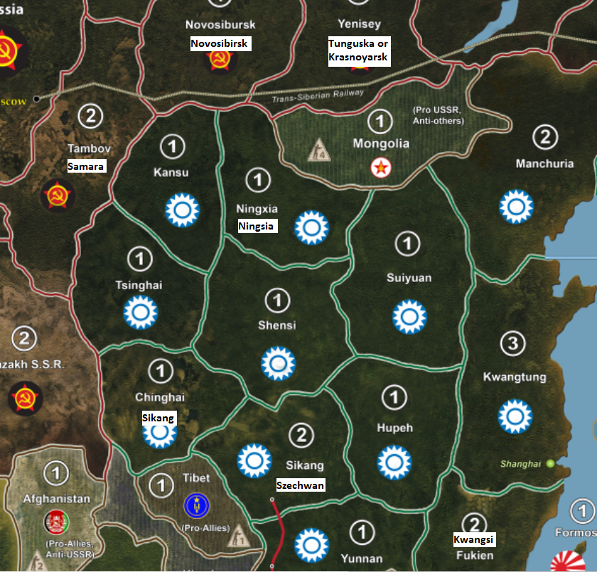
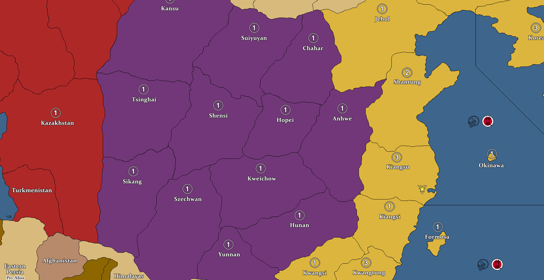
    Probably what happen for 2 different TTys bordering Kazakh SSR. on your map DK: Chinghai and Tsinghai.

    2 differents systems, 2 names but refering to the same and single chinese province.

    From historical accuracy, Wade-Giles system was the one use in WW2?

    I just found the older thread which discussed this matter, if you decide to make a few corrections eventually (since you can totally patch up China, if you which, nice video on youtube BTW):

    @Baron:

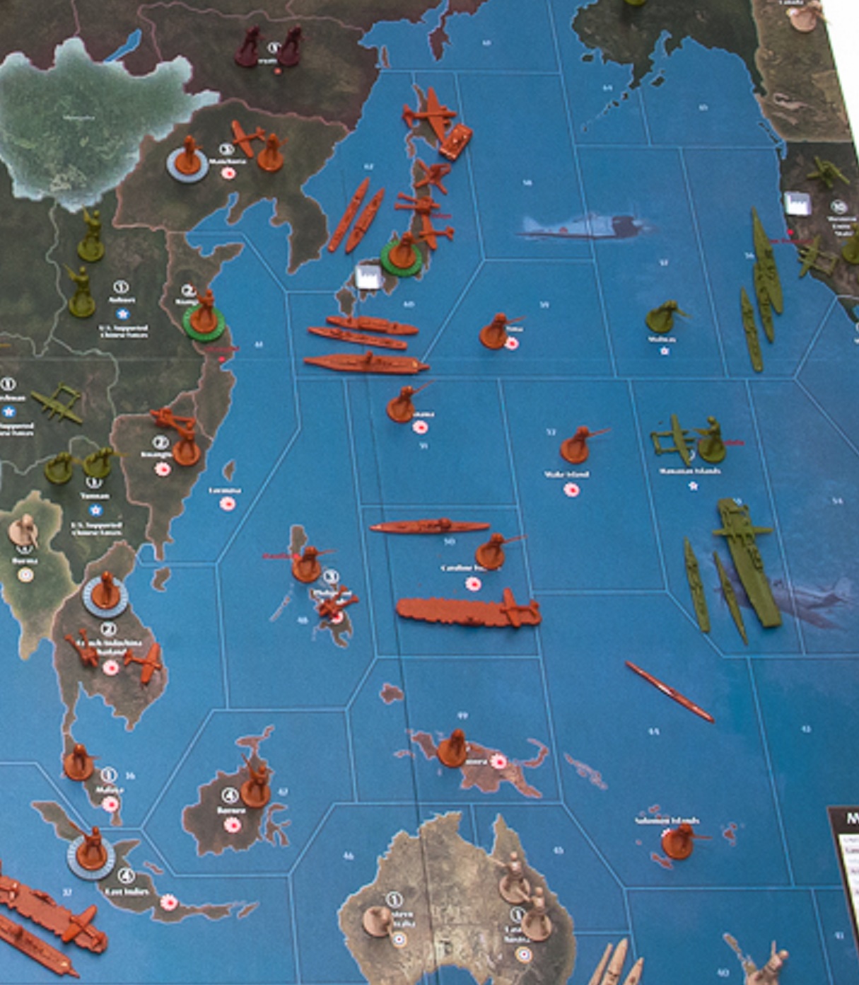
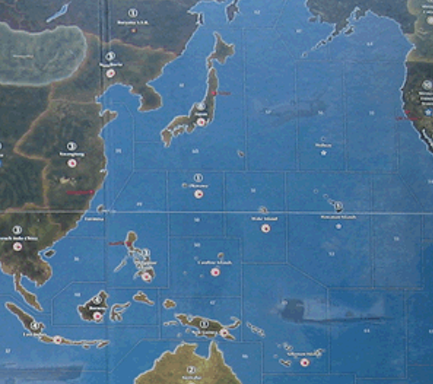
    DK, on your map I see 2 TTs east of Khazak SSR in China:
    1 is Tsinghai (North) and the other
    1 is Chinghai (South)

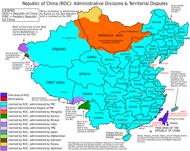
    In fact, it is the same region named now Qinghai.

    The southern region should have been probably named Sinkiang (Sikang on G40 map) or Xinjiang (modern name on Google map), if you followed G40 map.

    Based on general orientation on real map, I would have named from north to south western China TTs:
    North western TT Kansu/ Gansu  (Kansu on G40 map / and DK’s hybrid)
    Middle western TT Xinjiang (Tsinghai on G40 map / and DK’s hybrid)
    South western TT Tsinghai/ Qinghai (Sikang on G40 map / and Chinghai on DK’s hybrid).

    Kansu is north central in China only connected to Mongolia, but it has been connected on G40 map to Russian TT (Timguska) (Tambov and Novosibursk on DK’s).

    Middle TT I named Xinjiang is bordered on western side by Khazak SSR (and is the only direct access to Soviet TTs from China). (Correctly connected to Khazak and Tambov on DK’s hybrid)

    Southern TT I named Tsinghai / Qinghai doesn’t have access to Khazaz SSR or other TT but it is really bordering Tibet (Himalaya).

    Also Tambov is too far on West and north of Volgograd / Stalingrad.
    Samara should be a better choice as name for this region north of Kazakh SSR, west of Novosibursk and bordering China on your hybrid map.
    (As you had on G40 map.)
    However, to have named it Novosibirsk (instead of Tambov) would have been much better.

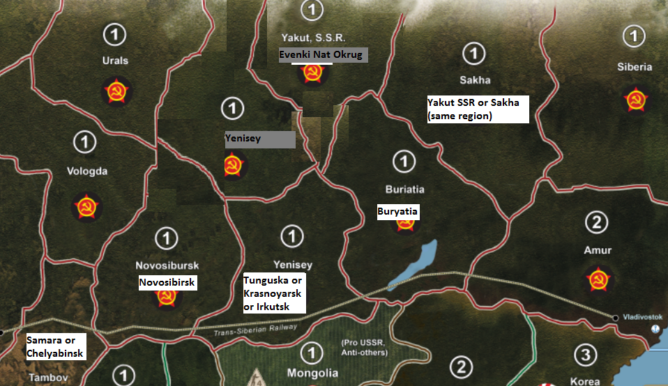
    And named Novosibursk: Krasnoyarsk because Irkustk (Timguska on G40) being Yenisey on your hybrid map.

    Was Novosib**u**rsk a typo error (“u” being just left of “i” on keyboard)?

    Take no offence DK, your map is awesome.
    I was just looking at these topographicals when I followed the leads.
    If you ever update your home map…

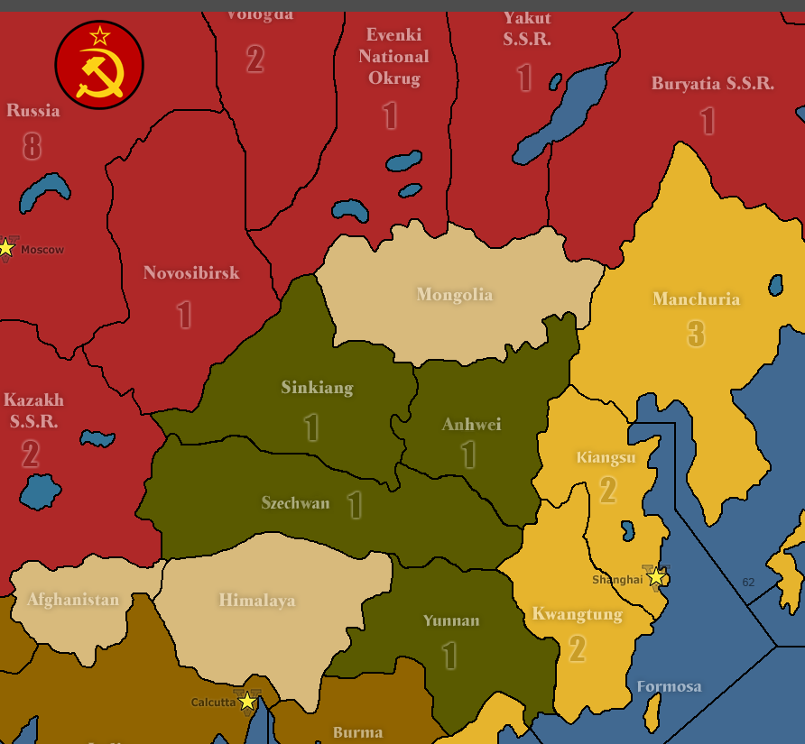
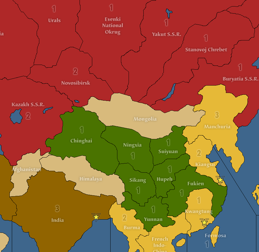
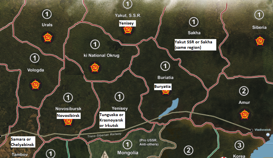
    On G40, Yakut SSR was wrongly named, it should have been Irkutsk.
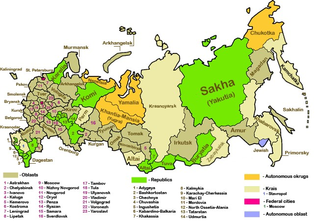
    Yakut SSR is the same as Sakha .

    As noted above, Sichuan or Szechwan, etc. is totally missing on your map. However, it is part of 1942.2 map. And on G40, it is at the right place, at the end of Burma road.

    @Baron:

    One in particular makes me realized that essentially Krasnoyarsk and Yenisey are almost the same region. In addition, Urals mount are further west than north of Mongolia.
    It is on northwestern side of Kazakh.
    Northwestern of Mongolia and along Yenisey river is the Central Siberian Plateau.
    It also showed than on your Map, Novo is correctly put west of Yenisey, but it is directly connected to Kazakh.
    So, on your hybrid map, it depends whether which border is more important to keep as accurate. Tambov is not the more accurate to describe what is north of Kazakh but west of Novosibursk. It needs to be in Siberian plain.
    The only major city on the eastern side of Urals is Chelyabinsk, aka Tankograd.
    So, that region on your map instead of Tambov, should be Chelyabinsk Oblast.

    Samara or, in WWII era Kouibychev, is also a valid name.
    It is west side of Urals on Volga river. Northeast of Stalingrad.

    Also learned that Samara in 1941 was preparing to receive all of Moscow political organs to established a temporary capital in case Moscow was captured.

  • '17 '16

    If you want to correct things in China with 1 patch to be close to G40 names.
    Just change names of 2 TTys north of Tibet.
    From left to right, Sikang instead of Chinghai.
    Szechwan instead of Sikang.

    Just a bigger patch in the same area.

    In addition, the Burma road did not end in Sikang. Szechwan is nearer from geographical POV, and Chongqing is also Capital City of Szechwan. However, Burma road ended in Shan State or in Yunnan.

    In the 20th century, as Beijing, Shanghai, Nanjing, and Wuhan had all been occupied by the Japanese during the Second Sino-Japanese War, the capital of the Republic of China had been temporary relocated to Chongqing, then a major city in Sichuan. An enduring legacy of this move is that nearby inland provinces, such as Shaanxi, Gansu, and Guizhou, which previously never had modern Western-style universities, began to be developed in this regard.[31] The difficulty of accessing the region overland from the eastern part of China and the foggy climate hindering the accuracy of Japanese bombing of the Sichuan Basin, made the region the stronghold of Chiang Kai-shek’s Kuomintang government during 1938–45, and led to the Bombing of Chongqing.

    https://en.wikipedia.org/wiki/Sichuan#Republic_of_China

    Also, along with Novosibursk which should be Novosibirsk, Buriatia should be written Buryatia.
    If willing to put another patch, this might connect these 2 TTys above:

    I think that Yenisey should be renamed Krasnoyarsk because the territory called Yenisey on the map appears to encompass most of Krasnoyarsk Kray (Kranoyarskiy Kray) or Krasnoyarsk Territory.

    http://www.axisandallies.org/forums/index.php?topic=38677.msg1588207#msg1588207
    This map help see major cities and region:
    http://www.vidiani.com/maps/maps_of_europe/maps_of_russia/administrative_map_of_russia.jpg


  • Sounds good for the next revision, Baron - thanks!

  • '19 '18 '17 '16

    Thanks DK for posting the updated map!  Now its time to find a printer and get rolling.


  • Glad you can use it!

  • '17 '16

    @Baron:

    If you want to correct things in China with 1 patch to be close to G40 names.
    Just change names of 2 TTys north of Tibet.
    From left to right, Sikang instead of Chinghai.
    Szechwan instead of Sikang.

    Just a bigger patch in the same area.

    In addition, the Burma road did not end in Sikang. Szechwan is nearer from geographical POV, and Chongqing is also Capital City of Szechwan. However, Burma road ended in Shan State or in Yunnan.

    In the 20th century, as Beijing, Shanghai, Nanjing, and Wuhan had all been occupied by the Japanese during the Second Sino-Japanese War, the capital of the Republic of China had been temporary relocated to Chongqing, then a major city in Sichuan. An enduring legacy of this move is that nearby inland provinces, such as Shaanxi, Gansu, and Guizhou, which previously never had modern Western-style universities, began to be developed in this regard.[31] The difficulty of accessing the region overland from the eastern part of China and the foggy climate hindering the accuracy of Japanese bombing of the Sichuan Basin, made the region the stronghold of Chiang Kai-shek’s Kuomintang government during 1938�45, and led to the Bombing of Chongqing.

    https://en.wikipedia.org/wiki/Sichuan#Republic_of_China

    Also, along with Novosibursk which should be Novosibirsk, Buriatia should be written Buryatia.
    If willing to put another patch, this might connect these 2 TTys above:

    I think that Yenisey should be renamed Krasnoyarsk because the territory called Yenisey on the map appears to encompass most of Krasnoyarsk Kray (Kranoyarskiy Kray) or Krasnoyarsk Territory.

    http://www.axisandallies.org/forums/index.php?topic=38677.msg1588207#msg1588207
    This map help see major cities and region:
    http://www.vidiani.com/maps/maps_of_europe/maps_of_russia/administrative_map_of_russia.jpg

    Hi DK, I found this map which might help getting straight with China. If you ever re-edit another version of your map.

    From top left to bottom left,
    Recent name (WW2 occidental name)
    0x- Xinjiang (Sinkiang) missing on your map and on G40
    1- Gansu (Kansu)
    2- Qinghai (Tsinghai) twice on your map.
    3- Xikang (Sikang)
    4x- Sichuan (Szechwan) missing on your map only
    5- Yunnan (Yunnan)

    then top left-center to center,
    1- Ningxia (Ningsia)
    2- Shaanxi (Shensi)

    and top right-center to center,
    1- Suiyuan (Suiyuan)
    2- Hubei / Hupei (Hupeh)

    finally, top right to bottom right (east coast of China)
    1- Manchuria …
    2- Guangdong (Kwantung)
    3- Fujian (Fukien) but it should be Guangxi (Kwangsi : Canton) because Fukien is only north of Kwantung not south.

    https://ww2db.com/country/China

    754px-ROC_Administrative_and_Claims.svg.png
    China in World War II _ World War II Database.pdf

  • '17 '16

    Here is a partial map of DKs Hybrid below, it will be easier to compare with above China regional map.

    From what I see, Pacific 1940.2 map of China completely ignored Sinkiang.
    Probably for game purpose because Sinkiang is a single territory which would totally occupy western China from Mongolia to Tibet and Himalaya.

    Also, you always use WW2 name except for Chinghai, which was a mistake repeating same name, and 1- Ningxia (Ningsia) which use the -xia instead of ww2: Ningsia.


    If you ever redraw the left portion of China.
    I would go with long band from north to south going from Novosibirsk to Himalaya and Tibet: Xinjiang (Sinkiang)
    This would block access to Soviet TTs for other chinese western TTs.

    Then four Chinese TTs from North to South Modern spelling (WW2 postal spelling):
    1- Gansu (Kansu)
    2- Qinghai (Tsinghai)
    3- Xikang (Sikang)
    4- Sichuan (Szechwan)
    Before reaching 5- Yunnan (Yunnan)
    And 6- Guangxi (Kwangsi) instead of Fukien on east coast.

    I would allow only Gansu (Kansu) to be linked to both Novosibirsk and Yenisey (same northern border of your actual Ningxia) for gameplay purpose.
    Ningxia (Ningsia) would be under Mongolia and not bordering any Soviet TTs, only to Gansu (Kansu) to the left for geographical accuracy, see Republic of China map above.

    DKs Hybrid China centered_names correction.png
    1942.2_China TripleA.png

  • '17 '16

    Here is two other maps of China.

    And now, we can see how AA50 made a bad choice, geographically speaking, by naming the Western part of China: Chinghai.
    It should have been Sinkiang! (I hope this will be addressed in new re-print of AA50.)
    And Sikang should have been named Szechwan (due to importance of Chongqing (Chungking)).

    AA50_China_TripleA.png
    Global40_China_TripleA.png

  • '17 '16

    @Baron:

    Also, along with Novosibursk which should be Novosibirsk, Buriatia should be written Buryatia.
    If willing to put another patch, this might connect these 2 TTys above:

    I think that Yenisey should be renamed Krasnoyarsk because the territory called Yenisey on the map appears to encompass most of Krasnoyarsk Kray (Kranoyarskiy Kray) or Krasnoyarsk Territory.

    http://www.axisandallies.org/forums/index.php?topic=38677.msg1588207#msg1588207
    This map help see major cities and region:
    http://www.vidiani.com/maps/maps_of_europe/maps_of_russia/administrative_map_of_russia.jpg

    I’m making some baby steps with paint.
    Since a picture worth a thousand words.
    Here is what I think is more accurate from a geographical POV.
    Yenisey basin has been put north where it poured into Arctic Ocean.
    Scarcely populated, I chose to name this TT according to geographical terrain. (Same as Urals on left and Siberia on the right.)

    Yakut SSR has return where it belongs, same region as Sakha, since it is simply a different older name, prior to USSR.

    It was created on April 27, 1922, during the Yakut Revolt and was transformed into the Sakha Republic in 1991.

    https://en.wikipedia.org/wiki/Yakut_Autonomous_Soviet_Socialist_Republic

    If you prefer to use G40 map names, you can use Tunguska (wrongly spelled Tim-guska) for southern Yenisey but it is part of administrative region of Krasnoyarsk (and Trans-Siberian make a stop in this city, too).

    Krasnoyarsk is a city and the administrative center of Krasnoyarsk Krai, Russia, located on the Yenisei River. It is the third largest city in Siberia after Novosibirsk and Omsk, with a population of 1,035,528 as of the 2010 Census. Krasnoyarsk is an important junction of the Trans-Siberian Railway and one of Russia’s largest producers of aluminum.

    https://en.wikipedia.org/wiki/Krasnoyarsk

    Tambov TT was quite misnamed since it is in fact west of Moscow.
    So, you can use the G40 map name instead: Samara but Soviet name was Kuybyshev.

    Samara, known from 1935 to 1991 as Kuybyshev, is the sixth largest city in Russia and the administrative center of Samara Oblast. It is situated in the southeastern part of European Russia at the confluence of the Volga and Samara Rivers on the east bank of the Volga.

    https://en.wikipedia.org/wiki/Samara
    Also, Samara was planned to be Capital-in-Exile for Stalin if Moscow had fallen.

    Stalin’s secret bunker was built in Samara so that he would be protected if Moscow fell to the German Army. It built not only to house Stalin but the Soviet government, The Central committee of the CPSU, and 22 missions if they needed to be evacuated from Moscow. Samara (Kuibyshev) was to become the official capital of the Soviet Union had this occurred. It was also considered to become the base from which all military operations would have been dispersed since it sat at a good strategic point on the Volga river.

    https://hague6185.wordpress.com/2013/08/08/world-war-ii-best-held-secret-revealed-in-samara-russia/

    You can rather chose Chelyabinsk, which is further east than Samara, on the eastern side of Urals Mount.

    By the mid-19th century, Chelyabinsk was a major trade center in Ural, and after the construction of the Trans-Siberian Railway in the 1890s it became an important transport hub that connected Siberia to the rest of the Russian Empire.

    https://en.wikipedia.org/wiki/Chelyabinsk_Oblast

    During the first Five-Year Plans of the 1930s, Chelyabinsk experienced rapid industrial growth. Several establishments, including the Chelyabinsk Tractor Plant and the Chelyabinsk Metallurgical Plant, were built at this time. During World War II, Joseph Stalin decided to move a large part of Soviet factory production to places out of the way of the advancing German armies in late 1941. This brought new industries and thousands of workers to Chelyabinsk. Facilities for the production of T-34 tanks and Katyusha rocket launchers existed in Chelyabinsk. During World War II, it produced 18,000 tanks, and 48,500 tank diesel engines as well as over 17 million units of ammunition. In the press of the time Chelyabinsk was informally called “Tankograd” or “Tank City”.

    https://en.wikipedia.org/wiki/Chelyabinsk

    DKs Hybrid Siberia and Mongolia.png

  • '17 '16

    Another things which puzzled me as I look deeper into Siberia’s part of your map is that going off the trail of Trans-Siberian is a faster way to reach Moscow. And from Amur to Moscow, the shortest way (5 TTs) is no longer than Berlin to Moscow!
    1- Amur
    2- Buryatia
    3- Evenki National Okrug
    4- Vologda
    5- Moscow

    And from Trans-Siberian:
    1- Amur
    2- Buryatia
    3- Yenisey
    4- Novosibirsk
    5- Vologda
    6- Moscow

    To be more realistic, I will not use Evenki National Okrug as a short cut toward Vologda.
    This can be done by linking Evenki to Urals (north) or Novosibirsk (south). See picture below.

    I would instead probably push westward actual Yakut SSR (I called Yenisey) on your map. So Evenki will be put eastward and blocked access to Yakut (my Yenisey) to north and west and Yenisey (I called Tunguska) would get direct access to both Evenki, Yakut (my Yenisey) and Novosibirsk.

    So, my Tunguska and my Yenisey basin will mark the Asian part of the G40 map. And Urals, Novosibirsk make for the Europe side of G40 Map.
    And using this moved Evenki road would be 7 TTs:
    1- Amur
    2- Buryatia
    3- Evenki National Okrug
    4- Yakut (my Yenisey) or south Yenisey (my Tunguska)
    5- Urals or Novosibirsk
    6- Vologda
    7- Moscow

    Keeping Trans-Siberian railroad the fastest way toward Moscow with 6 TTs:
    1- Amur
    2- Buryatia
    3- Yenisey (my Tunguska)
    4- Novosibirsk
    5- Vologda
    6- Moscow

    DKs Hybrid Siberia and Mongolia modified.png

  • '17 '16

    Here is the pic for the second option with 7 TTs north of Trans-Siberian.
    So, my Tunguska and my Yenisey basin will mark the Asian part of the G40 map. And Urals, Novosibirsk make for the Europe side of G40 Map.
    And using this moved Evenki Nat Okrug road would be 7 TTs:
    1- Amur
    2- Buryatia
    3- Evenki National Okrug
    4- my Yenisey or south Yenisey (my Tunguska)
    5- Urals or Novosibirsk
    6- Vologda
    7- Moscow

    Keeping Trans-Siberian railroad the fastest way toward Moscow with 6 TTs:
    1- Amur
    2- Buryatia
    3- Yenisey (my Tunguska)
    4- Novosibirsk
    5- Vologda
    6- Moscow

    DKs Hybrid Siberia and Mongolia modified version for 7 TTs north to Moscow.png

  • '17 '16

    I also found that Siberia as TT is kind of lame name for this Eastern part of Soviet Union…

    If you ever decide to revise all these Siberians TTs DK, I found this administrative division of Russia.
    This might help giving more accurate name. Of course, it is not WWII Soviet map but still better than nothing.

    Soviet Far East seems a nice twist.

    The Russian Far East (Russian: Дальний Восток России, tr. Dal�niy Vostok Rossii; IPA: [ˈdalʲnʲɪj vɐˈstok rɐˈsʲiɪ]) is the Russian part of the Far East, i.e. the extreme east parts of Russia, between Lake Baikal in Eastern Siberia and the Pacific Ocean. The Far Eastern Federal District, which covers this area, borders with the Siberian Federal District to the west. The Far Eastern Federal District has land borders with the People’s Republic of China and North Korea to the south west and maritime borders with Japan and the United States. Although traditionally considered part of Siberia, the Russian Far East is categorized separately from Siberia in Russian regional schemes (and previously during the Soviet era when it was called the Soviet Far East).

    https://en.wikipedia.org/wiki/Russian_Far_East

    You can also see that Vologda is a strange choice because on all AA map it is east of Arkhangelsk but it is truly between Moscow and Arkhangelsk, which is to the east! But, Finland forces captured part of this TT during 1941 toward the Moscow invasion.
    On Global map, Vologda is partly between Archangel and Moscow, this TT have to be crossed to reach Moscow from the north.
    However, it is not the case in AA50 or 1942.2.

    Russian-regions.png

  • '17 '16

    With all these games on your map, did you see some weakness or bias which encite some play patterns over others. Does Atlantic is too small compared to Pacific, or PTO too large compared to ATO? Enough Convoys zones? Etc.

    I provided Spring 1942.1 and 1942.2 PTO SZs map to get comparison points with your hybrid map.

    AA1942_Second Edition_Pacific SZs.jpg
    Spring1942Map_PTOSZs.png

Suggested Topics

  • 5
  • 2
  • 5
  • 51
  • 49
  • 1
  • 12
  • 15
Axis & Allies Boardgaming Custom Painted Miniatures

42

Online

17.0k

Users

39.3k

Topics

1.7m

Posts