

@gen-manstein very Awesome!!
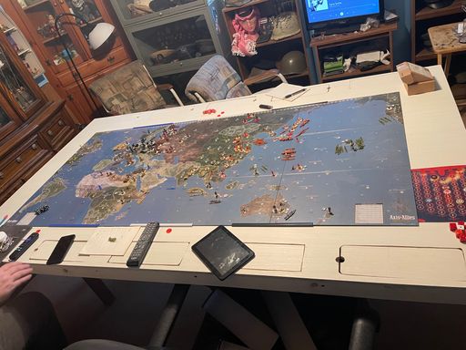
CWO Marc's Global 1940 Table
-
On each side of the raised platform, the card tables form an extension measuring 19 inches wide by 33.5 inches deep. These wings serve as multi-purpose working surfaces during game play. The duplicate Pacific 1940 panel on the left side of the platform can serve as an additional working surface, since its only function is to show where units end up when they cross the 90W line of longitude; the main game action takes place entirely on the section of the platform occupied by the four-panel Global 1940 map.
Under the card tables are some stackable shelving units (the flat-packed kind that you assemble yourself with a screwdriver), which I use to store sculpts and related equipment. The basic national sculpt sets (consisting almost entirely of OOB A&A units) which are shown in the photos reside there full-time, along with other trays containing roundels, special markers (such as those made by HBG), small wooden blocks in a range of colours, an assortment of plastic miniature poker chips, and miscellaneous goodies such as industrial complex sculpts of various types, tiny triumphal arches (good for marking victory cities), a few precious atomic bombs and a handful of little nuclear mushroom clouds. Whenever they’re needed for customized game purposes, there’s free space in the shelving units for trays of additional sculpts (not shown in the picture) such as the combat pieces made by HBG.
-
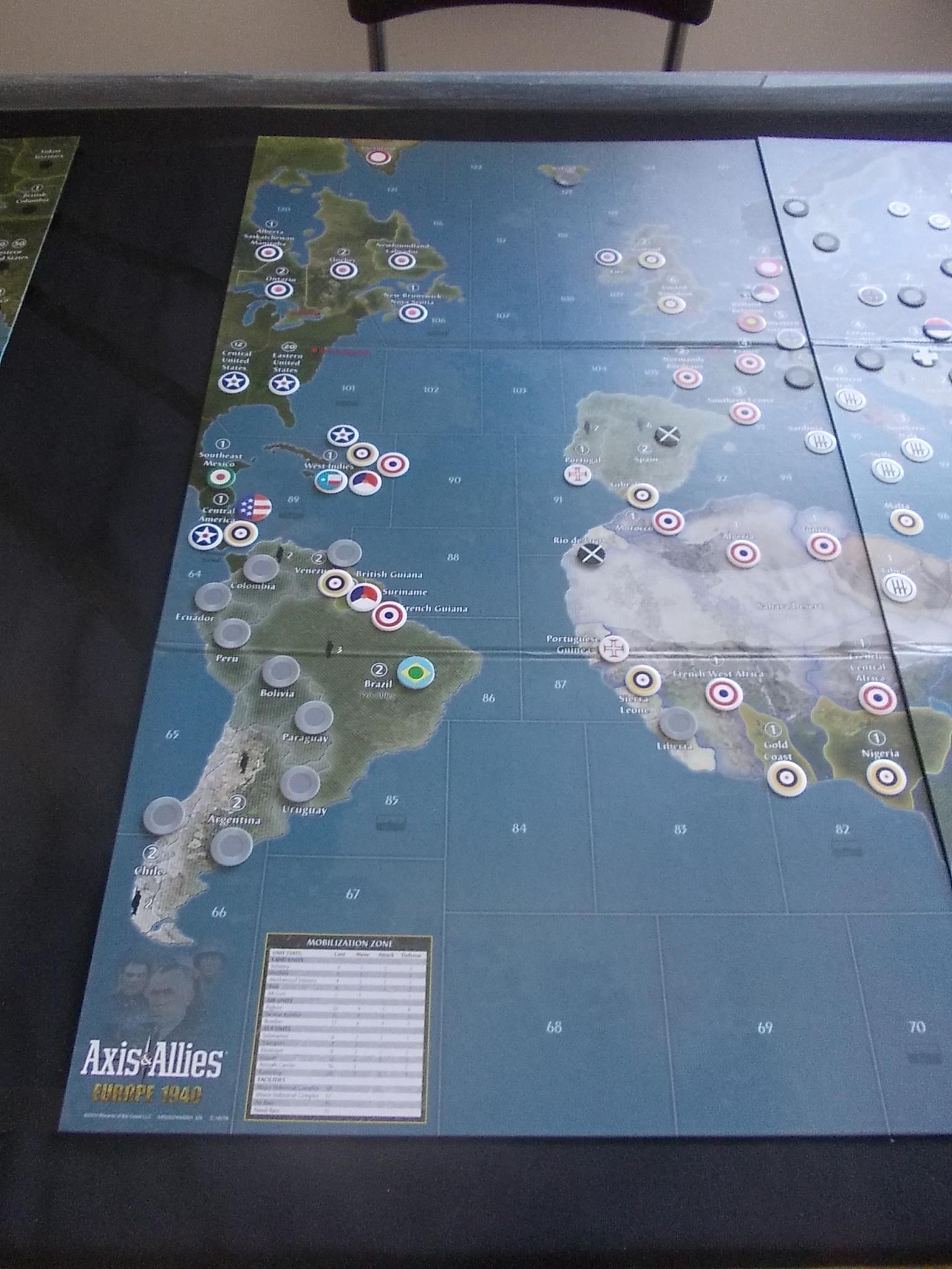
The remaining five pictures show the map panels in close-up with the sheet of acylic removed (you can see its upper edge leaning against the table at the top of the photos). The first one shows the connector panel and the black electrical tape that marks the connecting lanes. The connections don’t fully match the ones in the official rules; I tweaked them to make them more to my liking. Note that all the roundels printed on the map panel have been covered with self-adhesive black dots to show that this panel is not to be used for actual game play. Also note that, even though the electrical tape is highly visible in the first shot because of light reflection from the camera flash, it can barely be seen in the picture that will come after it. When I first built my table, I had originally used white thread to mark the connecting lanes. I later switched to black electrical tape because it sticks to the table (which helps it stay straight) and because black tape calls less attention to itself against black cloth than white thread: it’s easy to see if you pay attention to it and it’s easy to ignore the rest of the time.
-
These two shots are the Europe 1940 half of the Global 1940 map…

-
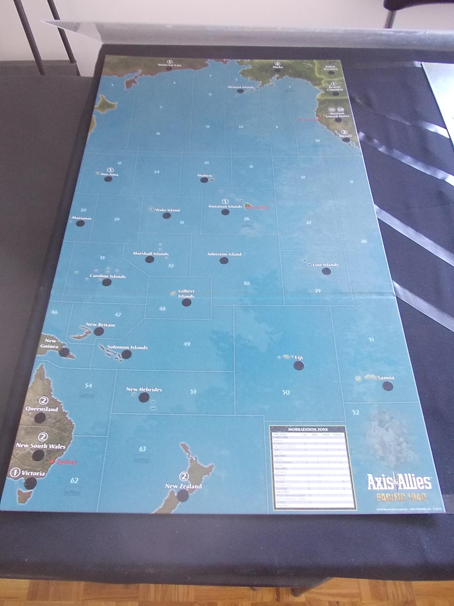
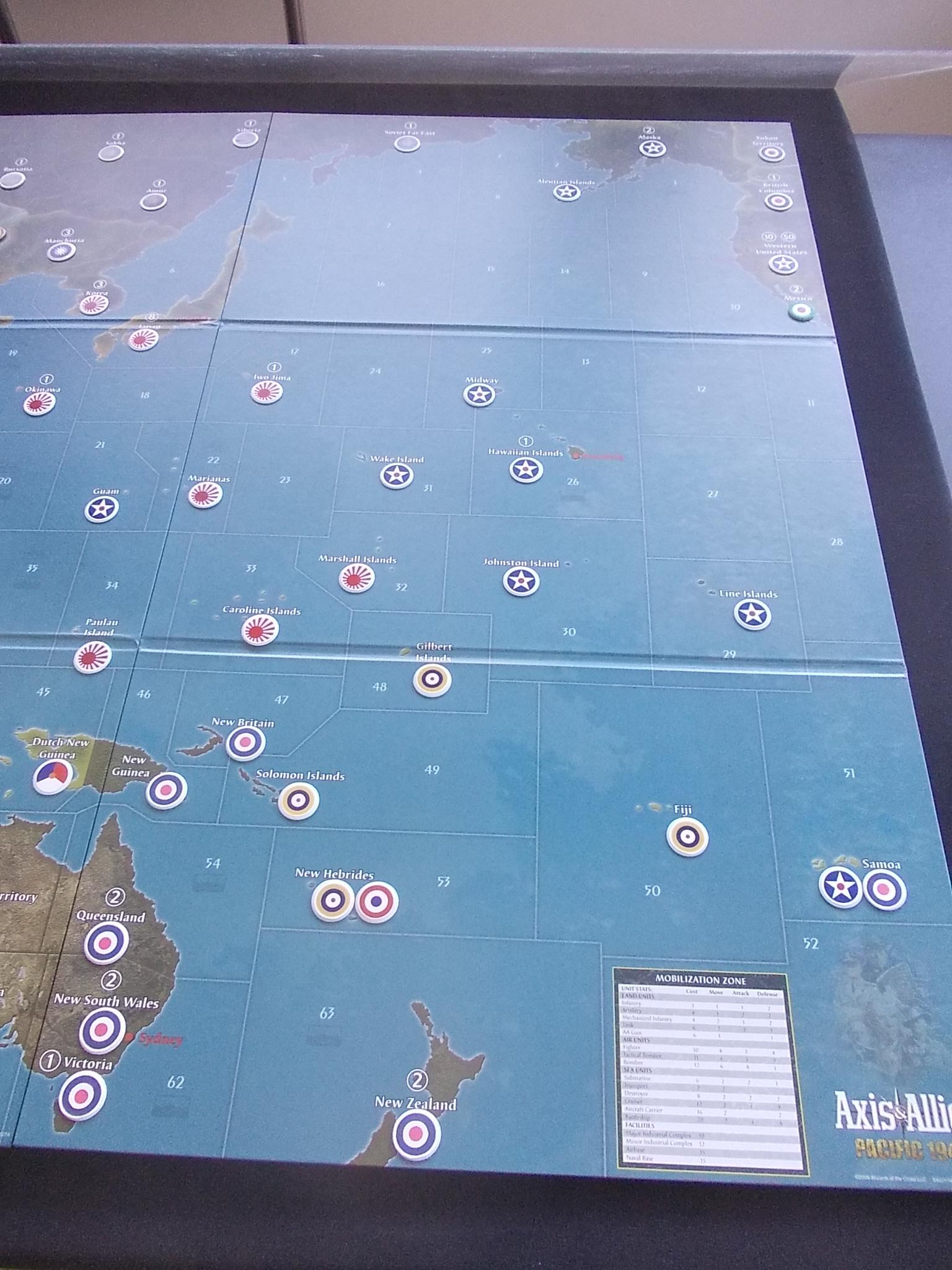
…and these two shots are the Pacific 1940 half. The only customization I’ve done has been the application of new roundels – but I’ve done so all over the game board. Many of the roundels you see in the photos are home-made ones; others were purchased from HBG, or taken from other games that I own. Most of the home-made ones consist of roundel designs that I got laser-printed onto sticky paper at a commercial print shop and which I then applied to opaque white bingo chips. A few others were improvised by sticking round Avery self-adhesive dots of various sizes to bingo chips. The easiest roundel type to devise was the one I picked to identify neutral states: A&A grey miniature poker chips, used straight out of the box.

-
The roundel customizations on this map probably look confusing – maybe even downright heretical to OOB rule purists – so here’s an overview of the reasoning behind them.
The first thing to remember is that the game map is intended to be covered with a sheet of transparent acrylic. Even though the map has got plastic and cardboard roundels stuck all over it, the acrylic covering means that the actual playing surface is completely smooth. The acrylic sheet, by the way, also eliminates the playing surface irregularities caused by the fold creases in the game board panels, or which can occur when the edges of two map panels don’t meet at exactly the same height.
In customizing my map, there were a number of things I wanted to accomplish:
-
I wanted the map to have bigger roundels than the ones which are printed on it, in order to improve their visibility. For example, the customized roundel in the map space for Karelia uses the standard Soviet roundel design – but it’s twice as big as the one printed on the map (if you include the white rim of the bingo chip).
-
I wanted Italy to use the black-and-white fascist roundel rather than the OOB one, out of personal preference. (One bonus of this decision: when I recently decided that I wanted Mexico to have its own roundel, I filled this gap by using the green-white-red OOB Italian roundel; it’s almost certainly inaccurate, but it was the best I could do with what I had on hand. I’ve had to use this kind of artistic license with several minor nations.)
-
I wanted to give the six Commonwealth Dominions – Canada, Newfoundland, Eire, South Africa, Australia and New Zealand – a common custom roundel, at least on the “default” customized map (its under-the-acrylic-sheet configuration). In practice, when overlay roundels and special markers are used on top of the acrylic sheet to prepare the map for an actual scenario set in a particular year of WWII, Eire becomes a neutral (it gets covered by an HBG neutral marker).
-
I wanted the Chinese Communists to have a customized roundel identifying Shensi (roughly where they ended up after the Long March) as a territory under their control.
-
I wanted to give separate roundels to countries that the game map treats as odd hybrids: places like Holland/Belgium and Slovakia/Hungary.
-
I wanted the minor colonial empires to be visible, similarly to the way in which the colonial holdings of the Netherlands are marked on the map with a distinct printed roundel. This meant providing roundels for use by Spain, Portugal, Belgium and Denmark.
-
I wanted to bring out the fact that some of the territories which are identified on the map by a single name and a single roundel were in fact multi-jurisdictional entities. Examples include the West Indies, Central America, Borneo, the New Hebrides and Samoa.
-
-
8 ) I wanted to give each named land space on the map (with the exception of impassable terrains) its own roundel, even if only a grey neutral roundel.
-
This one is going to sound a bit convoluted. I wanted to give an individual (or collective) roundel to those countries (or groups of countries) which met all three of the following conditions: a) they had no colonial holdings large enough to be represented by a named territory on the game map; b) they had not been knocked out of the war prior to the invasion of the USSR in June 1941; and c) they had joined the war on the Allied or Axis side no later than mid-1942. Basically, this has to do with my wanting to see at a glance who’s in and out of the war in scenarios which begin at the traditional A&A starting date of mid-1942, at the height of the Axis advance. In practical terms, this means giving roundels to the Axis minors (Romania, Hungary, Slovakia and Bulgaria) and to the Axis co-belligerents (Finland and Siam), and to some of the Allied minors (Mexico, the West Indies, Central America and Brazil), but not to Poland, Norway, Yugoslavia or Greece. Strictly speaking, in this context “the West Indies” actually means Cuba and the Dominican Republic, and “Central America” actually means Panama, Costa Rica and El Salvador, but I’ve retained the map’s terminology in both cases – in part because I had to use artistic license to assign roundel designs to those two groupings.
-
Partly because my collection of roundels from other games includes a few alternate Soviet hammer-and-sickle designs, I let myself be tempted to give Mongolia a distinct roundel. Mongolia was technically a neutral for most of WWII, but it participated with the USSR in the 1939 border war with Japan and in the Soviet invasion of Japanese-occupied Manchuria in August 1945. The official Global 1940 map shows Mongolia as a strict neutral, but in fact Mongolia at the time was under Communist rule and actively pro-Soviet.
-
I wanted the customized map to reflect reasonably well (within the constraints of what can be done simply by adjusting the roundels) the situation of the world as it existed prior to the Japanese invasion of Manchuria in 1931 – the first of the 1930s-era wars and annexations which preceded WWII. I like to use my Global 1940 map as a tool to explore alternate-history WWII scenarios, and I like to use 1931 as my starting point, so that’s the configuration I used for its default (“under the acrylic”) setup. That’s why on the customized map there are no Japanese roundels in China, and why Ethiopia and Greater Southern Germany are shown as neutrals. The custom setup isn’t, however, a perfect depiction of the world as it was in 1931. One reason has to do with the limitations of the names and borders which appear on the map itself (which I don’t have the capability of changing): for example, “Greater Southern Germany” would need to be labeled Austria and Yugoslavia. Another reason is, once again, artistic licence: Spain and Rio de Oro, for example, should have Republican roundels rather than Nationalist ones, but I gave myself the liberty of pre-building into the customized map the historical results of the Spanish Civil War (in part because I simply don’t like the colours of the Republican roundel). Anyway, using a pre-WWII default configuration did have interesting effects on the USSR’s western border: Vyborg got a Finnish roundel, the Baltic States and both halves of Poland got neutral roundels, and Bessarabia got a Romanian roundel. Making those changes really highlighted for me in a way I hadn’t previously realized just how systematically Stalin was building a buffer zone between himself and Germany in the couple of years prior to Operation Barbarossa. It was also a nice illustration for me of Larry’s remark in one of the A&A rulebooks that after playing his game you’ll come away with a deeper understanding of WWII.
I can’t think of any additional considerations that went into the current version of my customized map setup, but if I remember other points later I’ll add them in another post. I’ve made lots of changes to my custom roundel arrangement in the years since I first set up my table (some minor, others more significant), so I don’t expect that it will ever reach a static final configuration. The latest tweaks are only a couple of days old, so they may lead to others depending on how well I end up liking them.
-
-
I’m impressed chief, looks really good. Looking forward to see how you develop your global scenario.
Cheers,
Mitch -
I’m impressed chief, looks really good. Looking forward to see how you develop your global scenario.
Thanks. The project has been on hold for a while because I’m dealing with some time-consuming obligations in the real world, but I’ll get back to it at some point.
-
I love the level of detail to the map, have you considered using the Star of India from the British Raj for UK Pacific territories?
-
I love the level of detail to the map, have you considered using the Star of India from the British Raj for UK Pacific territories?
Glad you liked the custom map. No, the idea of giving the British Pacific territories distinct roundels hadn’t occurred to me. It’s a concept that has potential advantages, for instance because it would highlight Britain’s two-income situation in Global, but on the other hand I like having a single British roundel for the whole world because it highlights the extent of the British Empire. (A grade-school child back in the1930s or so allegedly wrote in an assignment that “The sun never sets on the British Empire because the sun sets in the west and the Empire is in the east.”)
Suggested Topics

