

I’ve created a separate thread for my work on the OOB 1914 map. Please go here to discuss it in more detail.
Images of the Map?
-
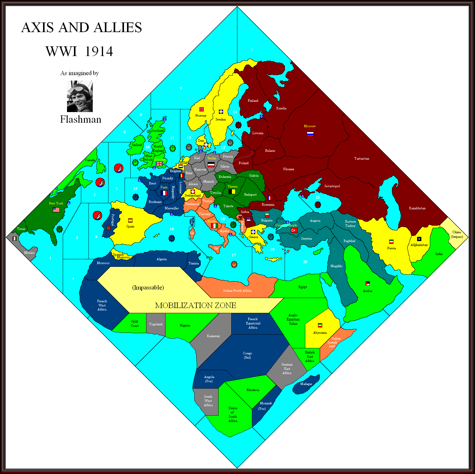
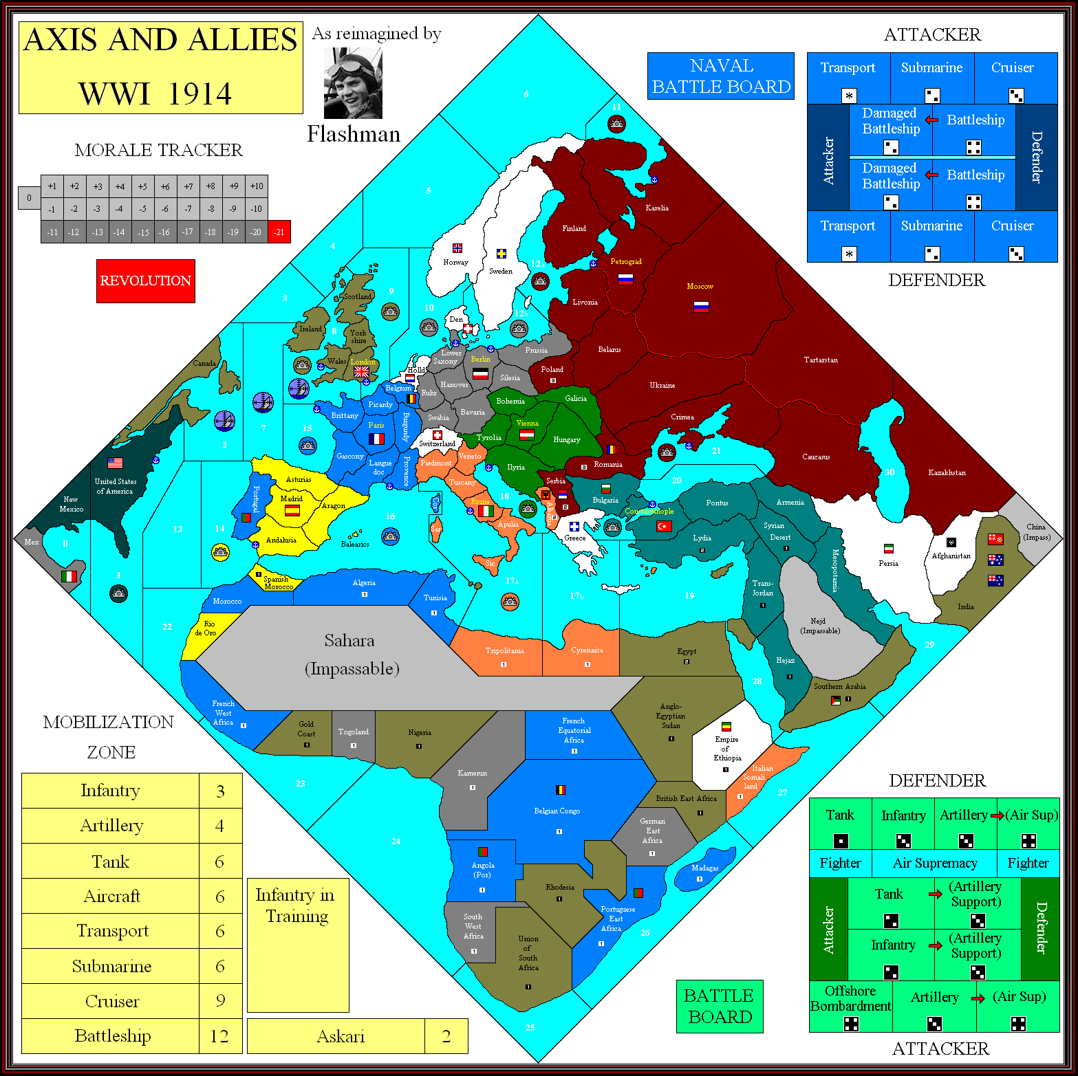
Sevastapol and Eastern Turkey might be the two most awkward adjacent territories an A&A history, if the clues led to the correct interpretation.
-
Latest Update.
I now think there may only be one Turkish SZ, covering both sides of the straits.
Can’t see the top of the map, but this may be important for the Allies dropping units into Karelia to support Russia.
They’ve probably followed Diplomacy in calling Western Britain “Wales”, but this would be correct only for a game set in the 7th century.
Got rid of the Colonial NBs, simply because I don’t think even Larry and his men would allow battleships to be built in these places.
This leaves us with:
New York
Scapa Flow
Portsmouth
Brest
Toulon
Taranto
Pola
Constantinople
Sevastopol
Kronstadt/PetrogradKiel
StettinArguably Kiel should cover the Baltic, with Wilhelmshavn the North Sea; but I doubt they would want both German bases located in the same tt.
Of course Konigsburg is another candidate for the Baltic NB, but seeing as L & Co have given it to Russia 31 years too early…
-
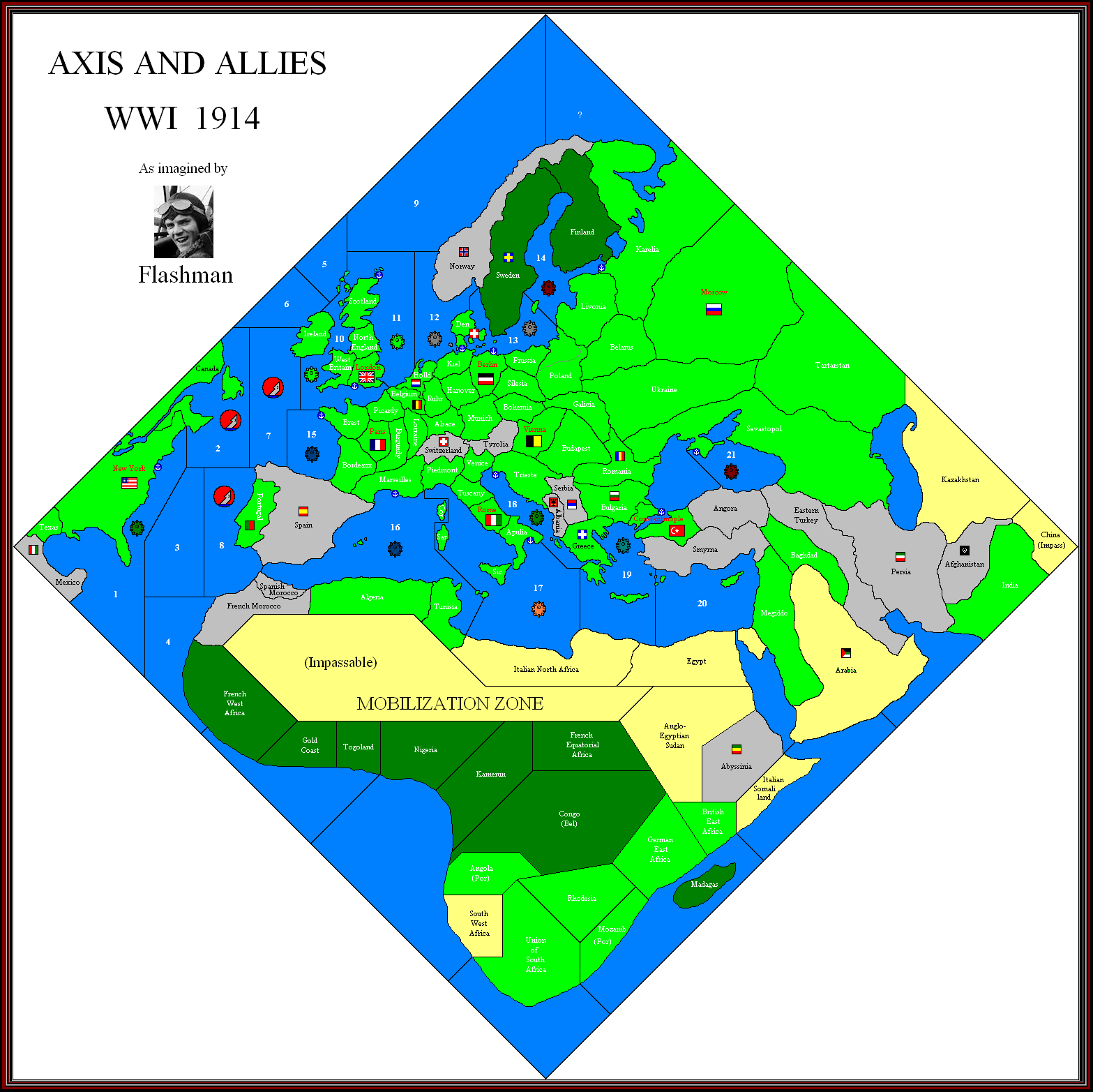
Variable terrain types version:
Tanks cannot enter mountains and jungle.
Aircraft restricted in jungle, possibly mountains.
No trains in the desert.
-
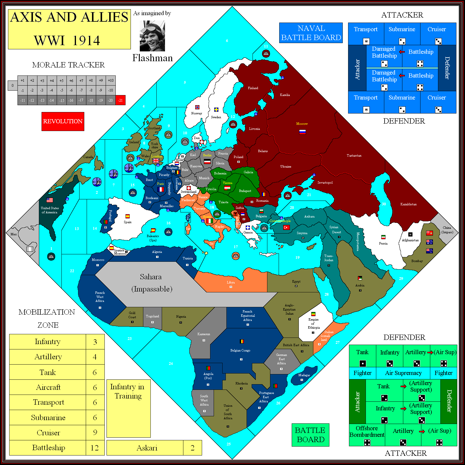
might be a stupid question, but with Belgian and portuguese colonies… do they get troops aswell if invaded? So 1 INF 1 ART per country (moz, ang, congo)…
-
I would assume they’re 1 IPC tts, though Congo has large mineral deposits that might bump it up to 2.
Larry didn’t mention their troops when reporting on France, so presumably they are not placed until either:1. A French unit enters them.
2. A CP unit attacks them.
This creates the anomaly that, for example, UK units are allowed to invade non-aligned Abyssinia, but cannot enter Portuguese Mozambique, even though it is supposedly pro-Allied.
I would have though that France at least gets to collect income from these colonies, as in effect Belgium becomes part of France when invaded. But it doesn’t seem so.
-
Just touting for suggestions on terrain effects in regard to the terrain map posted above:
Mountains: Tanks cannot enter; Artillery fire -1, Air observation limited - only one artillery promoted for each surviving aircraft.
Jungle/Forest: Tanks cannot enter; Artillery fire -1, No air observation.
Desert: Unit limit, say 8 units? (water in short supply) After every player turn reduce units to 8 maximum. If units of more than one power are present, each reduces one unit until limit is no longer exceeded. Each must leave an infantry as per battle casualties.
-
What do the flags represent on your map Flashman?
-
The large flags are the player capitals, small are neutral capitals.
-
No, not the national flags, the other flags you had on various border territories?
-
I did one map with lots of small flags for aspiring nations, to do with what happens when an Empire collapses.
Also there were some small tribal groups such as Senussi and Basmachi.
-
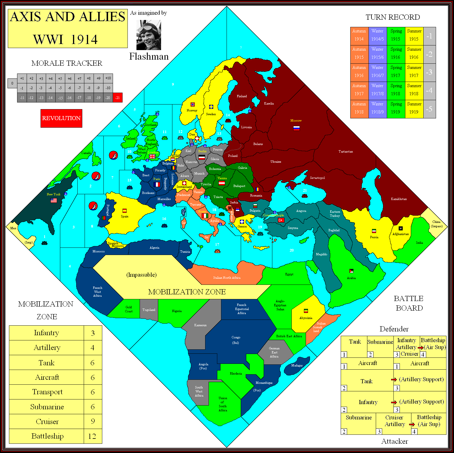
Latest Bells & Whistles map.
Still can’t make out the Turkish SZs.
Some minor changes in Africa.
Is it possible that there is just one SZ surrounding Britain?
-
I know I missed it somewhere, but are the colors for each nation listed?
-
I know I missed it somewhere, but are the colors for each nation listed?
Not sure if they are listed anywhere…
But this image of the map clearly shows the colors.
http://www.wizards.com/ContentResources/Wizards/Sales/Solicitations/2012_12_19_AA1914_Solicitation_en_US.pdf -
But I am color blind, that’s no help!
-
As it happens, so am I - I cannot therefore be accountable for the colours used on the map, especially the greens. In fact, I’m by no means certain the colour I’ve used for the USA is green.
Italy is meant to be orange, but when the pic is posted here the palette somehow changes it to pink.
-
The “Great Russia” border is to do with possible Revolution rules.
It looks really silly that the borders of SZ 17 & 19 don’t meet at the Libya/Egypt border, probably do do with how skewed the board’s projection is.
I’m concerned about the Allies invading Persia and Norway to supply Russia; if they’re allowed to do this it could be a game breaker.
If control of mines changes with that of the naval bases we’ll need mine control markers…
-
We’re nearly there. IPC values and maybe a couple of minor border changes.
SZ 18 is absurdly small, I’m guessing this is to stop Austria transporting units across to Naples.
-
Nine player game, anyone?
-
Are you suggesting Spain as a ninth player?
I see no other added power, but that is disastrously ahistorical. What can you possibly mean -
Sweden
Suggested Topics

