


Veqryn rules!
Mega error with the global map! Mayday! Mayday!
-
once we get a clear answer on whats adjacent to what, I plan on making a strip map that i can place on either side of the map to show adjacentcies.
For all we know the AAE40 manual could include it already in the Global rules.
-
Nah, why include something in the rules that can just be put in the errata 1 month after selling it? :wink:
-
A guy from PORTUGAL will never full understand you guys.
One thing i know: the two most brilliant countries in the world are Germany and USA.
Germany because of BMW and USA because of AA.
Don’t forget Germany’s contribution to the gaming industry–Settlers of Catan and Dominion games.
-
Can Krieghund or other master player answer how we can move naval units from the aap40 side to aae40 side of the map?
-
I can’t really talk about the game until after GenCon. However, this is addressed in the global rules, so maybe the next preview will provide an answer.
-
You went too far guys. Zooming in some parts of the world (for example Europe and Mediterraen sea) was brilliant, but not aligning the maps was something bad to the beautifulness of the game.
Of course there can be a rule saying that if you are in sea zone x then move to sea zone y on the other map, but this is more the logic of portals. A map is supposed not to have holes/dead ends in the middle.
-
I see your point MEGAEINSTEIN . In AA50 US & Canada missed by an inch or so, but the sz’s lined up. There was no real problem crossing over. I know in order to blow up Europe/Africa they had to shift stuff around. I printed off a copy of Holkann’s high res global map to check it out. They definitely should have elongated Canada (like on the Euro side) so W US & Mexico would be fairly close. I think its off at least 6-8 inches. Hell Mexico lines up great w/Wisconsin. I guess you can chalk it up to another mistake on Pac.
I can’t really talk about the game until after GenCon. However, this is addressed in the global rules, so maybe the next preview will provide an answer.
Hey did Wotc produce the game clue? Its like a secret passage from the Kitchen to the Study lol :-D
-
•Alberta/Saskatchewan/Manitoba territory is adjacent to both Yukon and British Columbia territories.
•Central United States is adjacent to Western United States.
•Southeastern Mexico is adjacent to Mexico.
•SZ 11 adjacent to SZ 64
•SZ 28 adjacent to SZ 64
•SZ 51 adjacent to SZ 64. 65. and 66
•SZ 52 adjacent to SZ 66
•SZ 64 adjacent to SZ 11, 28, and 51
•SZ 65 adjacent to SZ 51
•SZ 66 adjacent to SZ 51 and 52This was said by Jensen in preview 4.
Looks confusing.
-
This map by GrayBlaZe looks very helpful for crossing over near the US (Pac to Euro). I printed a copy as he suggested, it will help.
-
what is this? TETRIS? A puzzle? For God sake, what a disapointment in such a fantastic game.
The only units that crossed the map from the eastern end to the western end and back were a few american Planes, Troops, one US-destroyer and a britisch infantry in canada.
What’s your problem?
Don’t buy A&AE40 if this game sucks!
…or design your own map and bring it online.
-
I don’t even think it’s that confusing. There are four sea zones on the Pacific edge and three on the Europe edge. The top three Pacific zones are adjacent to the top Europe zone, the middle on each are adjacent, and the bottom two Pacific zones are adjacent to the bottom Europe one. How is that more confusing than the rest of the sea zones?
-
It just means the sea zones look like this:
|
11 |
|
| 64
28 |
|
|
|
|
51 | 65
|
|
_________|
| 66
52 |
| -
SAS thanks for the visualization.
Now i get it:
sea zones connect around the map (they are aligned in both maps).
Land zones are not aligned but we know how they connect.
I guess is the simple way to try to fix a bit this not aligment.
Anyway i would like that this didn´t hapen in future versions.
I have already said in this topic that i will buy the game and that the game seems to be fantastic.
AA is a working and evolving project.
If we don´t try to solve some problems, the game does not evolve and we all would be playing 1984 AA version.
-
“Southeastern Mexico is adjacent to Mexico.
SZ 11 adjacent to SZ 64”If the right edge of Southeast Mexico in the AA Pacific map connects to the left edge of Mexico in the AA Europe map, and SZ 64 connects to SZ 11, then SZ 10 (which is above SZ 11 and below Mexico) doesn’t seem to be covered in the rules for an East-West crossover. The lower right edge of SZ 10 seems to line up with the water to the west of Southern Mexico and Central America, which is the upper left part of SZ 64. So this suggests that you can go directly from SZ 64 to SZ 10. Is this correct?
-
SZ10 does not border Southern Mexico and Central America on the Europe map. It does not border anything at all on the Europe map which is why it isn’t mentioned in the ruling quoted. It only borders the Western US and Mexico territories.
I’ve attached a nice image someone made from the edges of the Pacific and Europe maps based on the connectivity rules. You can go to the actual thread here:
http://www.axisandallies.org/forums/index.php?topic=19618.0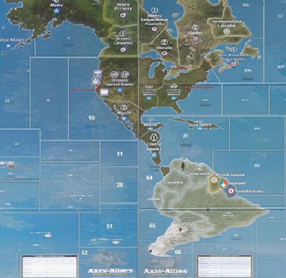
-
@SAS:
SZ10 does not border Southern Mexico and Central America on the Europe map. It does not border anything at all on the Europe map which is why it isn’t mentioned in the ruling quoted. It only borders the Western US and Mexico territories.
I’ve attached a nice image someone made from the edges of the Pacific and Europe maps based on the connectivity rules.Yes, on the connectivity map (which uses size distortions to make the connections line up) the corner separating SZ 10 from SZ 11 touches the border line between Southeast Mexico and Central America, so this prevents contact between SZ 64 and SZ 10. My concern is with the unmodified map which Djensen posted. When you put the two halves of Mexico side by side and try to make them fit together, you end up with a misalignment one way or the other:
-
If you line up the two halves of Mexico’s northern border, SZ 10 drops low enough that you can get to it from SZ 64.
-
If you line up the lower right end of SZ 10 with the westernmost point of Southeast Mexico at the edge of the map, SZ 10 is indeed blocked off from SZ 64, but the two halves of Mexico’s northern border no longer line up.
-
Making the lower right end of SZ 10 touch the border line between Southeast Mexico and Central America (as it does in the connectivity map) is only possible with the real maps by putting the left board over the right one rather than side by side.
Anyway, I’ll probably just do as other people are planning, which is to use arrows of some sort to indicate what connects to what, and simply ignore the fact that the geography of the two halves of the map doesn’t match very well.
-
-
Suggested Topics

