

I remember that this isn’t a fie that can be shared. He basically took an actual map and added decals and created the areas with markers. So its a “one off” map.
Tjoek's A&A Anniversary OOB Map file (Updated March 23rd)
-
I just returned from a week long skiing trip, so this is a short reply to hopefully answer some of the questions.
The scan has been created with 400 dpi. Knowing that 250 dpi is the limit for high quality print work, you can easily enlarge the print to 1.5 times the size of OOB. (roughly 71.1 inch by 36.6 inch)
Even a dpi of 200 might hardly be noticeable during game play so you could go to twice the OOB size. (88.9 inch by 45.8 inch)
@Imperious Leader: the file really is PNG. The pixel effect you see in the file is scanning noise which is created by the scanner. And saving it as PDF helps nothing in my case, given the fact my file is PNG already which is a lossless compression.
-
@P@nther:
I’ve never printed a game map before, but I am excited to start doing this, starting with Axis & Allies Anniversary Edition. With this file, if printed on vinyl at about 3 ft by 6 ft there anything I should know or processes I should take to get a clean, clear print?
This size can be achieved without modifying the pixel count and without quality effects simply by scaling: enhance dpi from 150 to 250.
While keeping the pixels at 17776x9162 this - when printing with 250 dpi - results in an image size of 71,1x36,6 inches, so approximately 6x3 ft.This is an easy task for your image manipulation software.
However, I am not a printing expert - so others hopefully add their knowledge regarding the printing aspects.
You are right P@nther, the files is limited by it’s pixels simply because it’s a scan of the original which has a limited pixel resolution. In this case it was scanned with 400 pixels per inch to keep file size reasonable and be able to enlarge the file to roughly twice the size of the original map.
-
@Nowhere:
Has anyone actually printed this map? Maybe its just me, i dunno, but it seems subdued/pixelated compared to the Adobe Maps of Dedo and Imperious… but i could totally be off base or maybe i need glasses?
At what size do you want to print the file? As per my last response you should be fine around 80 inch wide. But you can easily make a test print of a small portion of the map at the number of pixels per inch you want to go for to see the effects of enlarging the file.
Let me know if it helps if I create a few files of different enlargements that are small enough to print on a standard A4 or Letter page. Then you can see for yourself. Do know that colors will always differ between your home prints and professional print equipment.
-
@Imperious:
I think the minimum DPI should be 300 and to convert to jpeg due to memory issues will make the image unsustainable for any printing. I hope the work can be redone is another format to avoid the pixilation problem.
But you know my map redo is 100% vector, no image loss at any scale!
Imperious Leader, I just looked at your map and to be honest your map is NOT 100% vector. Yes your borders, roundels and country names are vector and will be crisp and clear no matter the size it’s being printed in. But the background of the countries is still a so called raster image just like my map file. To be honest to the community your raster image measures 6074 by 3242 pixels which is far less then mine 17776 by 9162 pixels.
So your map will not scale to any size perfectly, but I have to admit the borders, roundels and names will look more crisp then mine with sizes over twice OOB, due to the vector elements you’ve added. But the background of your countries will not.
-
@Nowhere:
Has anyone actually printed this map? Maybe its just me, i dunno, but it seems subdued/pixelated compared to the Adobe Maps of Dedo and Imperious… but i could totally be off base or maybe i need glasses?
At what size do you want to print the file? As per my last response you should be fine around 80 inch wide. But you can easily make a test print of a small portion of the map at the number of pixels per inch you want to go for to see the effects of enlarging the file.
Let me know if it helps if I create a few files of different enlargements that are small enough to print on a standard A4 or Letter page. Then you can see for yourself. Do know that colors will always differ between your home prints and professional print equipment.
Due to the limited playing surface we have, we’re looking only to print a map roughly 57" [wide], maintaining aspect ratio… we’d take it to a professional printer for either show floor or outdoor banner vinyl.
Simply looking for something as bright and clear as the OOB map would be fine (but printed so we can roll it up and have a seemless gameplay experience).
Would your map work for this, or would we need something altered or a different map alltogether?
-
That should be no problem, but please wait a few more days for a new file to be released as I’m doing some rework on the colours and brightness of the map. As well as some other small changes that YG asked me to do.
-
That should be no problem, but please wait a few more days for a new file to be released as I’m doing some rework on the colours and brightness of the map. As well as some other small changes that YG asked me to do.
Hi Tjoek,
By chance are you planning to do any work as far as enhancing the border colors in the Soviet territories to make them stand out more, which was part of my original request earlier in this thread? If not, I know someone who may be able to help me with his Photoshop software, but I’ll have him wait for the new file at this point. I look forward to seeing the new file and your new enhancements! -
That should be no problem, but please wait a few more days for a new file to be released as I’m doing some rework on the colours and brightness of the map. As well as some other small changes that YG asked me to do.
No problem waiting… though you might want to post your new map in the AA50 forum instead of customizations (just make sure to announce it in this thread to)…
By all means, i’ll be waiting.
-
Hi Tjoek,
By chance are you planning to do any work as far as enhancing the border colors in the Soviet territories to make them stand out more, which was part of my original request earlier in this thread? If not, I know someone who may be able to help me with his Photoshop software, but I’ll have him wait for the new file at this point. I look forward to seeing the new file and your new enhancements!Sorry I forgot about your message when the thread went into the quality / resolution discussion. With the colour and contrast corrections I’m currently working on I believe the borders should be more visible so please let me know how the file looks when it’s finished later this week.
-
Any chance when you’re done updating the changes to the AA50 map you can pop out a 2nd version with optional corrected roundels for Germany and Italy? It always bothered me they removed the historical emblems those countries used for more PC ones, all the while, we can get the correct roundel control markers from HBG (ty HBG)… I would just love to have my roundels (that our group already has and uses) to actually match what’s on the board… I mean not only did they remove the Fascist Italy roundel, but they replaced Italy’s roundel with Iran’s roundel… how annoying!
Anyways, if it’s possible to have these on a 2nd map option… or perhaps at least make a descent to-scale transparent background PNG with the correct roundel so we can pop it on there ourselves before taking it to the print shop?
Something like what HBG uses would be awesome (if you could be so kind). Our group can’t be the only one that uses these roundels from HBG.


P.S.
I don’t know your country of origin, so if you’re from Germany, you don’t have to explain German law, just pretend I didn’t even ask, I can respect that. -
@Nowhere:
Any chance when you’re done updating the changes to the AA50 map you can pop out a 2nd version with optional corrected roundels for Germany and Italy? It always bothered me they removed the historical emblems those countries used for more PC ones
Please know that the German roundel is the correct one from an airplane roundel perspective. If you want to display the flag of Germany during the war you’re right about the change.
As mentioned in one of my earlier posts I will create a version with the correct Italian roundel (the black and white one), but personally I don’t feel much for adding the German flag on the board. Simply because in my opinion the symbol should be left in the past. Furthermore it’s the flag and in my opinion you should change the other nations to their flags as well and it’s easy enough to add to my map file yourself.
BTW I’m not from Germany, but the Netherlands is next to it. :lol:
-
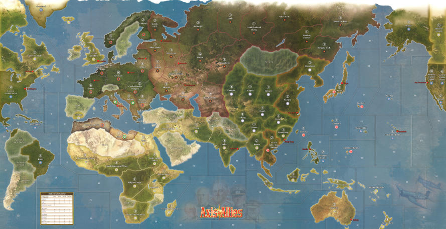
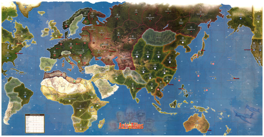
I’ve finished colour balancing the first map file which still contained to much red and green and looked a little dull.
At the same time I’ve done two important changes suggested by Young Grasshopper and his print shop:
-
I’ve added a white boarder to the map, which was a great suggestion from Young Grasshopper. This helps when cutting the map after printing so that you can be sure nothing of the real map has been cut off. The boarder is 1/4 inch wide when printing the map on 400dpi.
-
I’ve slightly filtered the map file to reduce the scanning noise and enhance the textures on the map
The link in my original post now points to the new file, but to give you a comparison between the two versions, see the smaller images below.
Please let me know what you think of this colour enhanced version!
-
-
Fantastic work Tjoek… sincerely an amazing contribution to the community.
-
…went to get it printed today for a friend and I nearly passed out when my print shop told me how big the print would be (119.84" X62.41"). Thankfully they turned it into a much smaller JPEG at the original size of 46" X 24" I’m going ahead with it and should have his print by next week, I’m waiting for the one with the income tracker for mine… here is the compressed file.
http://www.mediafire.com/file/2jhlkfiilcpp7at/Tjoeks 50AE Map File.jpg
-
whats a 46x24 map cost if you don’t mind me asking
-
whats a 46x24 map cost if you don’t mind me asking
Well, my print shop recently increased my prices which I wasn’t happy about… but they’ve told me they are locked in now. I getting the 46X24 printed on adhesive vinyl with a cold lamination to reduce scratches, than they will mount it on styrene which will give it durability and allow it to lay flat… after taxes it comes to $148.89 (Cnd).
-
@Young:
whats a 46x24 map cost if you don’t mind me asking
Well, my print shop recently increased my prices which I wasn’t happy about… but they’ve told me they are locked in now. I getting the 46X24 printed on adhesive vinyl with a cold lamination to reduce scratches, than they will mount it on styrene which will give it durability and allow it to lay flat… after taxes it comes to $148.89 (Cnd).
Hi YG, with the cold lamination step, are you still able to roll up the vinyl mat and have it still lay out flat? I need a portable solution for when I print my map. If not, how durable will a map printed on vinyl be without the cold lamination step during play and also rolling it up for transport and storage? I will find out the material that is available for me to print on where I am at. The person printing my map told me it was a high quality waterproof vinyl material (I can’t remember the exact name of it), but she told me it will last. Thank you.
I won’t know how well the cold lam map rolls until I see it, I’ve never got it before but my old maps are scratched up a bit and I figure it’s worth the money for added protection. I’ll let you guys know more when I get my map next week.
-
Sounds great YG! I’m looking forward to seeing how your map turns out!
-
Awesome update… so is the Italian (fasces) roundel version pending, or are we on our own for that one?
Please know that the German roundel is the correct one from an airplane roundel perspective. If you want to display the flag of Germany during the war you’re right about the change.
As mentioned in one of my earlier posts I will create a version with the correct Italian roundel (the black and white one), but personally I don’t feel much for adding the German flag on the board… Furthermore it’s the flag and in my opinion you should change the other nations to their flags as well and it’s easy enough to add to my map file yourself.
Just a quick shout-out here… the Japanese “roundel” in the game IS the Japanese flag, NOT their Roundel… but nobody complains of the Japanese Flag being used in game while the others are roundels… minor point of contention… the German roundel is the roundel, but if it were changed to their flag, it would NOT be the first such occurrence in the game, since the OOB map already has a major axis power flag in place of a roundel.
In any case, no biggie… my main point of contention is the Italian/Iranian roundel… shouldn’t be there for Axis Italy in any way shape or form… as you correctly mentioned earlier, it should be the fasces… that’s the only roundel i’m really wishing were changed on the map. Having Iran’s roundel for Italy is really off-putting.
Suggested Topics

